Gibraltar, Michigan facts for kids
Quick facts for kids
Gibraltar, Michigan
|
|
|---|---|
| City of Gibraltar | |

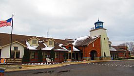
City of Gibraltar Municipal Complex
|
|

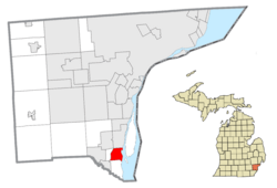
Location within Wayne County
|
|
| Country | |
| State | |
| County | Wayne |
| Settled | 1811 |
| Incorporated | 1954 (village) 1961 (city) |
| Government | |
| • Type | Council-manager |
| Area | |
| • City | 4.41 sq mi (11.42 km2) |
| • Land | 3.69 sq mi (9.55 km2) |
| • Water | 0.72 sq mi (1.87 km2) |
| Elevation | 581 ft (177 m) |
| Population
(2020)
|
|
| • City | 4,997 |
| • Density | 1,355.30/sq mi (523.31/km2) |
| • Metro | 4,285,832 (Metro Detroit) |
| Time zone | UTC-5 (EST) |
| • Summer (DST) | UTC-4 (EDT) |
| ZIP code(s) | |
| Area code(s) | 734 |
| FIPS code | 26-32020 |
| GNIS feature ID | 0626782 |
Gibraltar is a city in Wayne County, located in the state of Michigan. According to the 2020 census, Gibraltar had a population of 4,997 people.
It's part of the larger Metro Detroit area. The city is about 12 miles (19 km) south of the big city of Detroit. Gibraltar is next to the Detroit River on its east side. To the north is the city of Trenton, and to the south and west is Brownstown Township.
Contents
History of Gibraltar
People first settled in the area of Gibraltar as early as 1811. The community was officially mapped out on March 14, 1837. This was done by the Gibralter & Flat Rock Company.
The first post office opened here on October 2, 1837, and was called "Gibralter." The name changed a couple of times but went back to "Gibralter." On December 19, 1900, the spelling was changed to "Gibraltar."
Gibraltar was originally part of Brownstown Township. It became an official village in 1954. Later, in 1961, it became its own city.
Geography and Location
According to the United States Census Bureau, the city covers a total area of 4.41 square miles (11.42 square kilometers). Most of this area is land.
About 3.78 square miles (9.79 square kilometers) of Gibraltar is land. The remaining 0.63 square miles (1.63 square kilometers) is water. This means about 14.29% of the city's total area is water.
Population and People
| Historical population | |||
|---|---|---|---|
| Census | Pop. | %± | |
| 1960 | 2,196 | — | |
| 1970 | 3,842 | 75.0% | |
| 1980 | 4,458 | 16.0% | |
| 1990 | 4,297 | −3.6% | |
| 2000 | 4,264 | −0.8% | |
| 2010 | 4,656 | 9.2% | |
| 2020 | 4,997 | 7.3% | |
| U.S. Decennial Census | |||
2010 Census Information
In 2010, there were 4,656 people living in Gibraltar. These people lived in 1,946 households. About 1,283 of these households were families.
The city had about 1,231.7 people per square mile (475.6 people per square kilometer). There were 2,217 homes in total.
The average age of people in the city was 41.4 years old. About 22% of the residents were under 18 years old. Around 14.2% of the population was 65 years old or older. The number of males and females was almost equal.
Education in Gibraltar
Public schools in Gibraltar are managed by the Gibraltar School District. This district serves all of Gibraltar. It also covers parts of nearby Rockwood, Woodhaven, and Brownstown Township.
The school district operates several schools right in Gibraltar:
- Parsons Elementary School
- Shumate Middle School
- Carlson High School
See also
 You can also read about Gibraltar (Michigan) in Spanish for kids: Gibraltar (Míchigan) para niños
 | John T. Biggers |
 | Thomas Blackshear |
 | Mark Bradford |
 | Beverly Buchanan |


