Mitchell Township, Michigan facts for kids
Quick facts for kids
Mitchell Township, Michigan
|
|
|---|---|

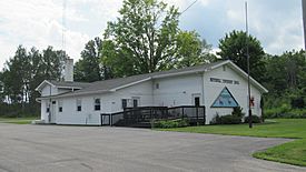
Mitchell Township Hall in Curran
|
|
| Motto(s):
"The Black Bear Capital of Michigan"
|
|

Location within Alcona County
|
|
| Country | |
| State | |
| County | |
| Organized | 1890 |
| Area | |
| • Total | 143.39 sq mi (371.4 km2) |
| • Land | 142.54 sq mi (369.2 km2) |
| • Water | 0.85 sq mi (2.2 km2) |
| Elevation | 886 ft (270 m) |
| Population
(2020)
|
|
| • Total | 354 |
| • Density | 2.47/sq mi (0.95/km2) |
| Time zone | UTC-5 (EST) |
| • Summer (DST) | UTC-4 (EDT) |
| ZIP code(s) | |
| Area code(s) | 989 |
| FIPS code | 26-54740 |
| GNIS feature ID | 1626750 |
Mitchell Township is a type of local government area called a civil township in Alcona County, Michigan. It's like a small town or district with its own local leaders. In 2020, about 354 people lived here.
Contents
What is Mitchell Township?
Mitchell Township is a part of Alcona County in the state of Michigan. It was officially set up in 1890. The township has its own local government that helps manage things like roads and services for the people living there.
Communities in Mitchell Township
- Curran is a small place within the township. It's an unincorporated area, which means it doesn't have its own separate city government. Curran is located right in the middle of Mitchell Township. The ZIP Code 48728, used for Curran, covers most of Mitchell Township.
Exploring the Geography of Mitchell Township
Mitchell Township covers a total area of about 143.39 square miles (371.38 square kilometers). Most of this area, about 142.54 square miles (369.18 square kilometers), is land. The rest, about 0.85 square miles (2.20 square kilometers), is water.
Main Roads in Mitchell Township
Two important state highways pass through Mitchell Township:
- M-65 runs from north to south through the center of the township.
- M-72 also goes through the middle of the township.
Sometimes, M-65 and M-72 run along the same road for a short distance. These highways help people travel in and out of the township.
Who Lives in Mitchell Township?
| Historical population | |||
|---|---|---|---|
| Census | Pop. | %± | |
| 1960 | 220 | — | |
| 1970 | 197 | −10.5% | |
| 1980 | 248 | 25.9% | |
| 1990 | 290 | 16.9% | |
| 2000 | 396 | 36.6% | |
| 2010 | 352 | −11.1% | |
| 2020 | 354 | 0.6% | |
| Source: Census Bureau. Census 1960- 2000, 2010. |
|||
In 2000, there were 396 people living in Mitchell Township. These people lived in 193 households, and 122 of these were families. The population density was about 2.8 people per square mile. Most people living in the township were White (97.73%).
Age and Income in the Township
In 2000, the population was spread out by age:
- 15.2% were under 18 years old.
- 2.5% were between 18 and 24.
- 18.2% were between 25 and 44.
- 37.4% were between 45 and 64.
- 26.8% were 65 years or older.
The average age of people in the township was 53 years old.
The average income for a household in the township was $26,875. For families, the average income was $33,875. About 16.5% of all the people in the township lived below the poverty line. This included 31.8% of those under 18 and 17.7% of those 65 or older.
Education in Mitchell Township
Children living in Mitchell Township attend schools that are part of the Fairview Area School District. This school district is located to the west of the township in Oscoda County.
See also
 In Spanish: Municipio de Mitchell (Míchigan) para niños
 | Ernest Everett Just |
 | Mary Jackson |
 | Emmett Chappelle |
 | Marie Maynard Daly |


