Mancelona, Michigan facts for kids
Quick facts for kids
Mancelona, Michigan
|
|
|---|---|
|
Village
|
|
| Village of Mancelona | |

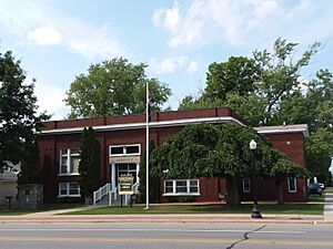
Mancelona Township Library
|
|

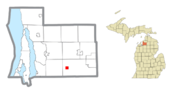
Location within Antrim County
|
|
| Country | United States |
| State | Michigan |
| County | Antrim |
| Township | Mancelona |
| Incorporated | 1889 |
| Named for | Mancelona Andress |
| Government | |
| • Type | Village council |
| Area | |
| • Total | 1.00 sq mi (2.60 km2) |
| • Land | 1.00 sq mi (2.60 km2) |
| • Water | 0.00 sq mi (0.00 km2) |
| Elevation | 1,125 ft (343 m) |
| Population
(2020)
|
|
| • Total | 1,344 |
| • Density | 1,339.98/sq mi (517.35/km2) |
| Time zone | UTC-5 (Eastern (EST)) |
| • Summer (DST) | UTC-4 (EDT) |
| ZIP code(s) |
49659
|
| Area code(s) | 231 |
| FIPS code | 26-50620 |
| GNIS feature ID | 0631374 |
Mancelona is a village located in the northern part of Michigan, a state in the United States. It's nestled within Antrim County and is part of Mancelona Township. In 2020, about 1,344 people called Mancelona home.
Contents
Exploring Mancelona's Past
How Mancelona Got Its Name
The story of Mancelona began in 1869. A person named Perry Andress settled in this area. He decided to name his new home after his daughter, Mancelona Andress. Just two years later, the larger Township of Mancelona was also created and named after her.
In 1872, a railroad line, the Grand Rapids and Indiana Railroad, was built through the area. A train station was set up here and was also called Mancelona.
The Iron Works Era
In 1882, a company called "John Otis & Company" built a large charcoal furnace south of Mancelona. They also planned a town around this furnace and named it Furnaceville. Soon after, the Grand Rapids and Indiana Railroad added a station in Furnaceville.
The furnace business grew quickly. In 1886, some businessmen from Grand Rapids bought the company. They renamed it Antrim Iron Works and the town became Antrim. A huge blast furnace and iron works were built. The new company was very busy making iron. The iron company closed down in 1945, and its buildings were taken down in the 1980s.
Discovering Mancelona's Location
Where is Mancelona Located?
Mancelona is a small village covering about 1 square mile (2.6 square kilometers) of land. It is located at coordinates 44°54′08″N 85°03′39″W.
Nearby Natural Beauty
Mancelona is special because it's close to many beautiful bodies of water. These include the Jordan River and the Elk River Chain of Lakes Watershed. One of the most famous nearby lakes is Torch Lake.
Mancelona's Population Over Time
| Historical population | |||
|---|---|---|---|
| Census | Pop. | %± | |
| 1880 | 105 | — | |
| 1890 | 1,205 | 1,047.6% | |
| 1900 | 1,226 | 1.7% | |
| 1910 | 1,200 | −2.1% | |
| 1920 | 1,214 | 1.2% | |
| 1930 | 1,143 | −5.8% | |
| 1940 | 1,173 | 2.6% | |
| 1950 | 1,000 | −14.7% | |
| 1960 | 1,141 | 14.1% | |
| 1970 | 1,255 | 10.0% | |
| 1980 | 1,432 | 14.1% | |
| 1990 | 1,370 | −4.3% | |
| 2000 | 1,408 | 2.8% | |
| 2010 | 1,390 | −1.3% | |
| 2020 | 1,344 | −3.3% | |
| U.S. Decennial Census | |||
A Look at the 2010 Population
In 2010, there were 1,390 people living in Mancelona. These people lived in 518 households, with 349 of them being families. Most of the people living in the village were White (95.1%). About 1.1% were Native American, and 3.7% were from two or more racial backgrounds. A small number, 0.9%, were Hispanic or Latino.
The average household in Mancelona had about 2.68 people. The average family had about 3.19 people.
Education in Mancelona
Mancelona Public Schools is the school district that serves the village. The sports teams from Mancelona are known as the "Ironmen."
Major Roads Connecting Mancelona
Mancelona is connected to other towns by several important highways:
 US 131 is a major highway that goes through Mancelona.
- To the northeast, it continues through towns like Alba and Boyne Falls. It ends at US 31 in Petoskey.
- To the southwest, US 131 goes through Kalkaska and Fife Lake. It then becomes a faster, limited-access road (like a freeway) heading south toward cities such as Grand Rapids and Kalamazoo.
 M-66 is another highway that runs north and south through Mancelona.
- To the north, M-66 goes through East Jordan and ends in Charlevoix.
- To the south, M-66 travels with US 131 for a bit to Kalkaska. It then continues south, passing through smaller communities like Lake City and Marion.
 M-88 is an east-west highway that starts in downtown Mancelona.
- M-88 stays entirely within Antrim County. It goes through towns like Bellaire and Central Lake. It ends at US 31 in Eastport.
 C-38 is a special county highway that extends M-88 to the east.
- East of Mancelona, C-38 enters Otsego County.
See also
 In Spanish: Mancelona (Míchigan) para niños
 | Roy Wilkins |
 | John Lewis |
 | Linda Carol Brown |


