Alba, Michigan facts for kids
Quick facts for kids
Alba, Michigan
|
|
|---|---|

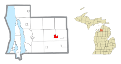
Location within Antrim County
|
|
| Country | United States |
| State | Michigan |
| County | Antrim |
| Townships | Chestonia and Star |
| Established | 1876 |
| Area | |
| • Total | 2.73 sq mi (7.07 km2) |
| • Land | 2.73 sq mi (7.07 km2) |
| • Water | 0.00 sq mi (0.00 km2) |
| Elevation | 1,178 ft (359 m) |
| Population
(2020)
|
|
| • Total | 287 |
| • Density | 105.32/sq mi (40.66/km2) |
| Time zone | UTC-5 (Eastern (EST)) |
| • Summer (DST) | UTC-4 (EDT) |
| ZIP code(s) |
49611
|
| Area code(s) | 231 |
| GNIS feature ID | 619894 |
Alba is a small community in Antrim County, Michigan. It is not a city or town with its own government. Instead, it is called an "unincorporated community." It is also a "census-designated place" (CDP). This means the U.S. Census Bureau has drawn official borders around it. This helps them count the people living there.
In 2020, about 287 people lived in Alba. You can find Alba just north of Mancelona. It is located along U.S. Route 131. The community is split between two areas: Star Township and Chestonia Township.
How Alba Started
Alba began in 1876. It was first a small stop called Cascade. This stop was along the Grand Rapids and Indiana Railroad. A "flag station" was a place where trains would only stop if someone waved a flag.
At that time, Cascade was part of Forest Home Township, Michigan. A post office opened there in December 1877. The area was officially mapped out the next year. In 1884, the name changed to Alba. It was named after a local performer, Alba Haywood.
Alba was first counted as a census-designated place in 2010. This was the first time it had official borders. It also got its own population numbers.
Where is Alba?
Alba is located in the state of Michigan. The U.S. Census Bureau says Alba covers an area of 2.73 square miles (7.07 square kilometers). All of this area is land. There is no water within its official borders.
Who Lives in Alba?
In Alba, there are 128 homes. The average income for a household is about $79,808. Most adults in Alba have jobs, with about 84.2% of people working.
Most people in Alba are White, making up about 94% of the population. About 0.6% are Black, and 0.3% are Hispanic or Latino. About 3.4% of the people are of two or more races.
| Historical population | |||
|---|---|---|---|
| Census | Pop. | %± | |
| 2010 | 295 | — | |
| 2020 | 287 | −2.7% | |
| U.S. Decennial Census | |||
See also
 In Spanish: Alba (Míchigan) para niños
 | Kyle Baker |
 | Joseph Yoakum |
 | Laura Wheeler Waring |
 | Henry Ossawa Tanner |


