
Malin Head facts for kids

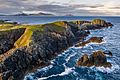
Malin Head (which is Cionn Mhálanna in Irish) is a famous place in County Donegal, Ireland. It's on the Inishowen Peninsula and is the most northern point of mainland Ireland! The very tip of Malin Head is called Dúnalderagh. It sits at a latitude of 55.38 degrees North.
Malin Head is so important that a part of the sea is named after it in the Shipping Forecast. This is a special weather report for ships. The whole area of Malin Head stretches north of the Black Mountain. It's not just one spot, but a whole region with many local names that come from old Norse and Irish languages. There's also a weather station here. It's one of 22 stations that send reports for the BBC Shipping Forecast. You can also see an old tower built in 1805 on a hill called Altnadarrow, or Tower Hill.
Long ago, in the 2nd century AD, a writer named Ptolemy described a northern point in his book Geography. He called it Boreion, which means "the northern". People think he was probably talking about Malin Head!
Dúnalderagh, the northernmost part of Malin Head, is about 16 kilometers (10 miles) north of the village of Malin. Even further north than Malin Head is Inishtrahull Island, which is about 10 kilometers (6 miles) away. The very northernmost land in Ireland is a rock called Tor Beg. Malin Head is also home to small businesses like pubs, restaurants, and shops. There's even a large call center there that provides jobs for many local people.

Contents
Exploring Malin Head's Surroundings
If you look to the northeast from Malin Head, you can see Inishtrahull Island. The first lighthouse on this island started working in 1813. Its light flashes every 30 seconds to guide ships.
Below the Altnadarrow hill, to the east, you'll find Ballyhillion beach. This beach is very special because it's a "raised beach system." This means the land has risen over time, showing old shorelines. These distinct lines tell us how the sea and land changed after the glaciers melted about 15,000 years ago. Back then, County Donegal was pushed down by a huge sheet of ice. So, the sea level was much higher, up to 80 feet higher than it is today!
Did you know that parts of the movie Star Wars: The Last Jedi were filmed right here in Malin Head?
Malin Head Weather Station
Weather reports from Malin Head began way back in 1885. In 1955, a new weather station was built by Met Éireann, Ireland's weather service. This station is right next to the coastguard station. Here, they record weather information every hour, like sunshine, wind, and rain.
Malin Head's Climate
Malin Head has a mild oceanic climate. This means it's usually not too hot or too cold. Strong winds and storms are common for much of the year. Summers are generally mild, while winters have cool days and clear nights. The amount of sunshine is quite low throughout the year, but it's usually brightest in May.
| Climate data for Malin Head (1981–2010, extremes 1885–present) | |||||||||||||
|---|---|---|---|---|---|---|---|---|---|---|---|---|---|
| Month | Jan | Feb | Mar | Apr | May | Jun | Jul | Aug | Sep | Oct | Nov | Dec | Year |
| Record high °C (°F) | 14.4 (57.9) |
15.0 (59.0) |
19.0 (66.2) |
20.7 (69.3) |
25.1 (77.2) |
27.2 (81.0) |
27.0 (80.6) |
27.1 (80.8) |
28.9 (84.0) |
22.8 (73.0) |
17.6 (63.7) |
16.8 (62.2) |
28.9 (84.0) |
| Mean daily maximum °C (°F) | 8.1 (46.6) |
8.1 (46.6) |
9.3 (48.7) |
10.8 (51.4) |
13.1 (55.6) |
15.1 (59.2) |
16.8 (62.2) |
17.0 (62.6) |
15.6 (60.1) |
13.0 (55.4) |
10.4 (50.7) |
8.6 (47.5) |
12.2 (54.0) |
| Daily mean °C (°F) | 5.9 (42.6) |
5.8 (42.4) |
6.9 (44.4) |
8.3 (46.9) |
10.5 (50.9) |
12.7 (54.9) |
14.5 (58.1) |
14.7 (58.5) |
13.3 (55.9) |
10.8 (51.4) |
8.2 (46.8) |
6.4 (43.5) |
9.8 (49.6) |
| Mean daily minimum °C (°F) | 3.6 (38.5) |
3.5 (38.3) |
4.4 (39.9) |
5.8 (42.4) |
7.8 (46.0) |
10.3 (50.5) |
12.1 (53.8) |
12.3 (54.1) |
10.9 (51.6) |
8.5 (47.3) |
6.1 (43.0) |
4.2 (39.6) |
7.5 (45.5) |
| Record low °C (°F) | −6.2 (20.8) |
−6.7 (19.9) |
−5.0 (23.0) |
−3.9 (25.0) |
−0.6 (30.9) |
2.6 (36.7) |
5.6 (42.1) |
4.8 (40.6) |
2.0 (35.6) |
0.0 (32.0) |
−2.6 (27.3) |
−5.5 (22.1) |
−6.7 (19.9) |
| Average precipitation mm (inches) | 117.4 (4.62) |
84.8 (3.34) |
85.9 (3.38) |
63.1 (2.48) |
56.9 (2.24) |
69.1 (2.72) |
76.8 (3.02) |
93.2 (3.67) |
91.8 (3.61) |
118.4 (4.66) |
104.5 (4.11) |
114.2 (4.50) |
1,076 (42.36) |
| Average precipitation days (≥ 0.2 mm) | 22 | 18 | 20 | 16 | 16 | 16 | 18 | 19 | 19 | 21 | 21 | 20 | 226 |
| Average snowy days | 5.1 | 5.2 | 3.4 | 1.6 | 0.1 | 0.0 | 0.0 | 0.0 | 0.0 | 0.0 | 1.1 | 3.8 | 20.4 |
| Average relative humidity (%) (at 15:00 LST) | 80.8 | 77.0 | 77.1 | 75.7 | 75.7 | 78.7 | 80.6 | 79.8 | 77.5 | 77.6 | 79.7 | 81.3 | 78.5 |
| Mean monthly sunshine hours | 37.2 | 65.0 | 93.0 | 153.0 | 201.5 | 165.0 | 142.6 | 136.4 | 111.0 | 80.6 | 45.0 | 34.1 | 1,264.4 |
| Source: Met Éireann | |||||||||||||
Malin Head During Wartime

An old military watchtower was built on Altnadarrow in 1805. This was during the Napoleonic Wars, a time of big conflicts in Europe. Around 1902, the Marconi Company built a signal station near this old watchtower. Both of these buildings are still standing today.
During World War II, Ireland remained neutral. However, the Irish government allowed the British Government to set up two special radio devices at Malin Head. These were called radio direction finders. This was a very secret operation. The equipment helped the Allied forces (like the British and Americans) track German U-boats (submarines) and planes in the North Atlantic. A book about the history of radio at Malin Head was published in 2014.
If you look north of Altnadarrow, just before Dúnalderagh, you can see a large ground marker. It spells out '80 EIRE' using stones. This was a message to planes flying overhead. It let them know they were crossing Irish territory and that Ireland was a neutral country during the war.
Wildlife at Malin Head
Malin Head is a fantastic spot for watching birds, especially in autumn! Many seabirds, like gannets, shearwaters, skuas, and auks, fly south during their migration. Sometimes, very rare seabirds, like the Black-browed Albatross, have been seen here. It's also a great place to spot amazing sea creatures. You might see Basking sharks or a group of Bottle-nosed Dolphins that live in the area.
Gallery
-
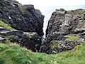
Hell's hole cavern.
-
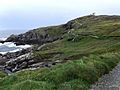
Malin head coastline looking towards the north.
-
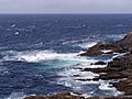
View of the rugged coast around the Head.
-
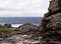
Low tide beneath the cliffs at Malin Head.


Images for kids
-
Looking out into the North Atlantic from Malin Head
-
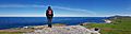
Malin Head panorama looking NE to Tor Beg Rock
.jpg)
See also
 In Spanish: Cabo Malin para niños
