Inishtrahull facts for kids
Quick facts for kids
Inishtrahull
Inis Trá Tholl
|
|
|---|---|
|
Island
|
|
 |
|
| Sovereign state | Ireland |
| Province | Ulster |
| County | County Donegal |
| Area | |
| • Total | 0.34 km2 (0.13 sq mi) |
| Elevation | 49 m (161 ft) |
| Population
(2011)
|
|
| • Total | 0 |
| • Density | 0/km2 (0/sq mi) |
| Time zone | UTC+0 (WET) |
| • Summer (DST) | UTC+1 (IST (WEST)) |
| Irish Grid Reference | C439548 |
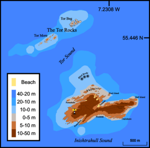
Inishtrahull is a small island located off the coast of County Donegal in Ireland. It is the most northerly island in Ireland. Its name comes from the Irish language, meaning "island of the hollow beach." Another Irish name for the island means "island with the beach on the opposite side."
The island is quite small, covering about 0.34 square kilometers (0.13 square miles). It lies about 10 kilometers (6 miles) north-east of Malin Head, which is the northernmost point of mainland Ireland. Inishtrahull is famous for having Ireland's northernmost lighthouse. People lived on the island until 1929, and lighthouse keepers stayed there until 1987. Today, no one lives on Inishtrahull, and it is a protected area because of its important wildlife.
Contents
Discovering Inishtrahull's Ancient Rocks
Inishtrahull is made of a special type of rock called granitic gneiss. This is a metamorphic rock, which means it has changed over time due to heat and pressure. This rock is known as Inishtrahull Gneiss.
Scientists have found that this rock is incredibly old, about 1.7 billion years old! This makes it the oldest known rock in all of the Irish Islands. The rocks on Inishtrahull are connected to similar ancient rocks found on other islands like Islay and Colonsay.
Exploring Inishtrahull's Marine Life
The waters around Inishtrahull are home to many different types of algae, which are like sea plants. These include various species such as Bonnemaisonia asparagoides, Callophyllis laciniata, Ulva lactuca, and Fucus serratus. These sea plants are an important part of the island's marine ecosystem.
Inishtrahull's Past: People and History
Even though Inishtrahull is empty now, it once had a small community. People lived there until 1929. After that, only lighthouse keepers remained until 1987.
In 1929, the entire community left the island. This event was even discussed in the Dáil, which is Ireland's parliament. A local politician, Deputy Carney, said that the islanders had to leave because of illegal fishing. He explained that large fishing boats from other countries were catching too many fish, making it hard for the islanders to earn a living with their small boats.
However, the Minister for Fisheries at the time, Fionán Lynch, disagreed. He believed that illegal fishing was not the main reason for the islanders leaving. He said that many families on the island worked for the Irish Lights boat service, which brought supplies to the lighthouse. He also reported that the families were not in "poor circumstances" after moving.
The population of Inishtrahull changed a lot over the years:
| Historical population | ||||||||||||||||||||||||||||||||||||||||||||||||||||||||||||||||||||||||||||||||
|---|---|---|---|---|---|---|---|---|---|---|---|---|---|---|---|---|---|---|---|---|---|---|---|---|---|---|---|---|---|---|---|---|---|---|---|---|---|---|---|---|---|---|---|---|---|---|---|---|---|---|---|---|---|---|---|---|---|---|---|---|---|---|---|---|---|---|---|---|---|---|---|---|---|---|---|---|---|---|---|---|
|
|
|
||||||||||||||||||||||||||||||||||||||||||||||||||||||||||||||||||||||||||||||
| Source: | ||||||||||||||||||||||||||||||||||||||||||||||||||||||||||||||||||||||||||||||||
The Last Glimpse of Ireland: Inishtrahull Lighthouse
Inishtrahull is home to the most northerly lighthouse in Ireland. It is managed by the Commissioners of Irish Lights. The first lighthouse started working in 1813. This was important because ships of the Royal Navy began using Lough Foyle nearby.
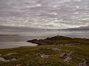
Today, the lighthouse flashes its light every 30 seconds. You can still see the ruins of the old lighthouse and a newer one built in 1956. The lighthouse became automated in March 1987. This meant machines took over the work, and the last three lighthouse keepers left the island on April 30, 1987.
For millions of Irish people who left for the "New World" across the Atlantic, Inishtrahull and its lighthouse had a special meaning. Many of these emigrants sailed from Derry. The lighthouse was often the last piece of Ireland they would see. One emigrant remembered:
“[The voyage] was quite pleasant for a while. There was, however, one milestone to pass, Inishtrahull lighthouse off the coast of Donegal was the last glimpse emigrants would have of Ireland [and] everyone stayed on deck until it disappeared. They stayed on when they couldn’t see it anymore because the more keen-sighted kept saying it is still there. When the sharp-eyed ones admitted the light had faded all frivolity ceased, handkerchiefs came out and there was much sniffing as we drifted off to our staterooms. The next stop was New York”
Visiting Inishtrahull: Wildlife and Exploration
Inishtrahull is famous for its amazing wildlife. It is a Special Area of Conservation and a Special Protection Area. These titles mean the island's nature is protected by the National Parks and Wildlife Service.
The island's location and lighthouse attract many unusual birds. It also has a population of grey seals. During the summer, many basking sharks and cetaceans (like whales and dolphins) come to the waters around the island.
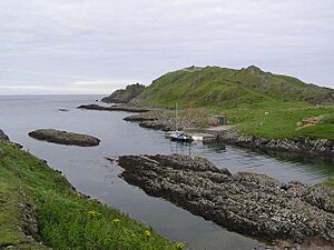
Many scuba divers use Port Mór on the island as a lunch spot. They explore the hundreds of shipwrecks found off the island's shores. Getting to the island can be tricky because of the strong tides and currents around Malin Head. There are also rules about landing on the island, set by the National Parks and Wildlife Service and the Commissioners of Irish Lights. Visitors are asked to be extra careful during May to July, which is when birds are breeding. As of 2015, there are two Geocaches on the island for treasure hunters to find.
Images for kids
See also
 In Spanish: Inishtrahull para niños
 | Victor J. Glover |
 | Yvonne Cagle |
 | Jeanette Epps |
 | Bernard A. Harris Jr. |


