River Nith facts for kids
Quick facts for kids River Nith |
|
|---|---|

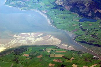
The estuary of the River Nith, opening into Solway Firth south of Dumfries
|
|
| Country | Scotland |
| Physical characteristics | |
| Main source | Enoch Hill 55°19′41″N 4°17′02″W / 55.328°N 4.284°W |
| River mouth | Solway Firth |
| Length | 71 mi (114 km) |
| Basin features | |
| Basin size | 1,230 km2 (470 sq mi) |
- For the river in southwestern Ontario, see Nith River.
The River Nith (in Scottish Gaelic: Abhainn Nid) is a river in south-west Scotland. It begins high up in the Carsphairn hills in East Ayrshire. The river flows mostly south through Dumfries and Galloway. It then empties into the Solway Firth at a place called Airds Point. The area around the river is known as Nithsdale.
Contents
How Long is the River Nith?
Measuring the exact length of a river can be tricky, especially where it meets the sea. For rivers like the Nith, which flow into wide, shallow areas, the length changes with the tide.
When the tide is low, the sea pulls back a lot. This makes the River Nith appear much longer. At low tide, the Nith stretches about 113.8 kilometers (70.7 miles). This makes it the seventh longest river in Scotland.
Protecting the River Nith
The area where the River Nith meets the sea is very important for nature. Because of this, it is protected by special rules.
Home for Wildlife
The Nith estuary is a vital place for many birds, especially in winter. It's a feeding ground for waders (birds that wade in shallow water), geese, and other wildfowl. This is why it's part of the Upper Solway Flats and Marshes Ramsar site and a Special Protection Area. These are international agreements to protect important wetlands and bird habitats.
Many barnacle geese from Svalbard spend their winters here. The area is also part of the Solway Firth Special Area of Conservation. This protects important natural places and animals like sea lamprey and river lamprey. On a national level, it's a Site of Special Scientific Interest and part of the Caerlaverock National Nature Reserve.
A Beautiful Landscape
The Nith Estuary is also a National Scenic Area. This means it's recognized for its amazing views and natural beauty. Scotland has 40 such areas. They are protected to make sure that new buildings or projects don't spoil the beautiful scenery.
The Nith Estuary National Scenic Area covers a large space, about 14,337 hectares. This includes land and the sandy or muddy areas that are covered by water at high tide. The local council, Dumfries and Galloway Council, helps manage this special area.
Rivers Joining the Nith
Many smaller rivers and streams flow into the River Nith. These are called tributaries. Here are some of them, listed from upstream (closer to the source) to downstream (closer to the sea):
- Connel Burn
- Afton Water
- Kello Water
- Crawick Water
- Euchan Water
- Mennock Water
- Carron Water
- Cample Water
- Scar Water
- Shinnel Water
- Cluden Water
- Cargen Pow
- New Abbey Pow
Towns and Villages Along the Nith
Several towns and villages are located along the banks of the River Nith.

See also
 In Spanish: Río Nith para niños
 | James Van Der Zee |
 | Alma Thomas |
 | Ellis Wilson |
 | Margaret Taylor-Burroughs |


