Galloway Hills facts for kids
The Galloway Hills are a group of mountains in the south of Scotland. They form the northern edge of western Galloway. These hills are part of the larger Southern Uplands mountain range.
The Galloway Hills are located inside the Galloway Forest Park. This park is a huge area of wild land, about 300 square miles (780 km2) big. It's managed by Forestry and Land Scotland. You'll find some interesting place names here, like those from Old Norse and Scottish Gaelic. These names show the many different cultures that have influenced this area over hundreds of years.
Contents
Where are the Galloway Hills Located?
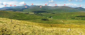
Galloway is surrounded by the sea to the west (North Channel) and south (Solway Firth). The "Galloway Hills" are to the north, and the River Nith is to the east. When people say "Galloway Hills," they usually mean a specific group of mountain ranges. These ranges are mostly south of Loch Doon and cross different local government areas.
The border between Dumfries and Galloway and Ayrshire runs right through the heart of these hills, near Loch Enoch.
Northern and Western Borders
The northern edge of the Galloway Hills is near the small towns of Dalmellington and Straiton in Ayrshire. The B741 road runs between these towns and can be seen as the northern boundary.
From Straiton, a smaller road goes south through the northwest part of the hills. It meets another road that runs north from Glentrool village. This second road follows the Water of Minnoch valley and forms the western border of the Galloway Hills. It passes through many forest plantations.
Eastern Border
The A713 road, which goes from Castle Douglas to Ayr, forms the eastern border. As it heads south from Dalmellington, it goes through a valley called the Glenkens. This valley separates the Galloway Hills from the Carsphairn and Scaur Hills to the east.
There's a large hydro-electric power system (built in 1935-1936) in the Glenkens. It has several dams and power stations. The A713 road passes through towns like Carsphairn and St John's Town of Dalry. It also goes near New Galloway at Kenbridge, which is at the north end of Loch Ken.
From New Galloway, the A712 road crosses through the hills to Newton Stewart. Along this road, you'll see Clatteringshaws Reservoir, the Queen's Way, a deer range, and Murray's Monument.
Southern Border
For many hikers, the "Galloway Hills" means the ranges north of a line from Loch Trool, Loch Dee, and Clatteringshaws Reservoir. This area is considered the true heart of the hills. The Southern Upland Way and National Cycle Network Route Number Seven follow this line.
Outlying Hills to the South
South of the A712 road, east of Clatteringshaws Reservoir, is a hill called Cairnsmore of Dee (493 meters). It offers great views into the main Galloway Hills. Further south, near Cairnsmore of Fleet, is another range of hills. The top of Cairnsmore of Fleet is over 2 km long. Even further south, there are smaller coastal hills around Cairnharrow, near Gatehouse of Fleet. The A75 road runs close to the Solway Firth shore beyond these hills.
Hills Named Cairnsmore
Besides Cairnsmore of Dee and Cairnsmore of Fleet, there's a third important "Cairnsmore." This is Cairnsmore of Carsphairn. It's about 5 km northeast of Carsphairn and is a prominent hill east of the Rhinns of Kells ridge.
How to Access the Hills by Road
- About 2 km south of Dalmellington on the A713, there's a forestry toll road. This road goes down the west side of Loch Doon. It passes the rebuilt Loch Doon Castle and comes out at Stinchar Bridge. This route is used by the Barr to Loch Doon Cycle Route.
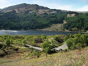
- From Glentrool village, a small road goes east to Bruce's Stone, on the north side of Loch Trool. This road is about 6 km long and stops for cars there. However, the N7 National Cycle Network Route continues from there to Clatteringshaws.
- You can drive to Craigencallie (OS ref. NX503780), which is halfway between Loch Dee and Clatteringshaws. The road to Craigencallie is just west of the dam at Clatteringshaws Reservoir on the A712.
The Three Main Ridges
The main part of the Galloway Hills is north of Loch Trool. Many great walks into this wild area start from the large car park near Bruce's Stone. There are three main ridges that run north from the Loch Trool/Loch Dee/Clatteringshaws area:
- The Range of the Awful Hand on the west.
- The Rhinns of Kells to the east.
- The Dungeon Hills in the middle.
The Range of the Awful Hand
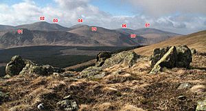
The 'Awful Hand' ridge includes these peaks from north to south: Shalloch on Minnoch, Tarfessock, Kirriereoch Hill, Merrick, and Benyellary. Merrick is the highest hill in southern Scotland. These five hills have ridges extending west, making them look like a hand. Benyellary is like the thumb.
This ridge is about 9 km long in a straight line. Even though it sounds short, there are some tough climbs, especially around Kirriereoch Hill and Merrick. Hikers also have to walk at least 3 km from any road to reach the ends of the ridge.
The Rhinns of Kells
The Rhinns of Kells ridge runs from north to south. It starts at Black Craig on the east bank of Loch Doon. Then it includes Coran of Portmark, Meaul, Carlin's Cairn, Corserine, Millfire, Milldown, Meikle Millyea, Little Millyea, and Darrou. Darrou is about halfway between Loch Dee and Clatteringshaws.
The Rhinns of Kells is about 15.5 km long in a straight line. The ridge has a double curve, making it a bit longer to walk. It's generally a gently rolling ridge, which makes for relatively easy hiking.
The Dungeon Hills
The Dungeon Hills run from north to south. They include Craigmawhannal (south of Loch Doon), Hoodens Hill, Mullwharchar, Dungeon Hill, Craignairny, Craignaw, Snibe Hill, and Craiglee. Craiglee is a bit separate, lying at the eastern end of the Rig of the Jarkness. It's just north of Loch Dee.
The 'Dungeons' ridge is about 11 km long in a straight line. These hills are not as high as some on the other two ridges. However, most of them (except Mullwharchar) are much rockier and more rugged. This makes them popular with climbers.
In 1978, there was a plan to drill on Mullwharchar to test for dumping nuclear waste. Local people protested a lot, and the plan was rejected.
Between the Ridges
There are lower areas between the Dungeon Hills and the other two ridges. These low areas form two "corridors" that run through the hills from north to south.
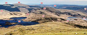
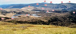
The highest loch in the western corridor is Loch Enoch. Its surface is about 490 meters above sea level. Loch Trool is about 70 meters above sea level. This means the corridor rises quite a lot as it goes for about 5 km between the hills.
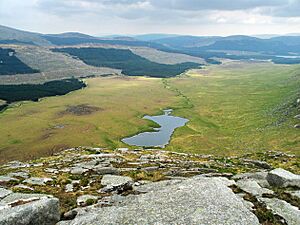
The highest loch east of the Dungeons is Dry Loch of the Dungeon, around 330 meters above sea level. Most of the Silver Flowe bog, just south of it, is fairly flat at about 270 meters. This is because the Silver Flowe is a special type of bog called a blanket bog, which is naturally flat.
Lochs Between the Awful Hand and the Dungeons
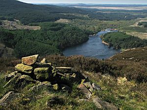
Two small streams, called burns, flow into the eastern end of Loch Trool on its northern shore. These are the Buchan Burn (to the west) and the Gairland Burn. They are separated by a 3 km long ridge called the Buchan Ridge. This ridge runs north from Buchan Hill to Craig Neldricken, south of Loch Enoch.
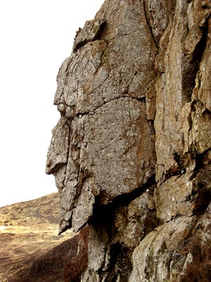
You can use the Buchan Burn route to reach Loch Enoch. You'll pass the Grey Man of the Merrick on your left before Loch Enoch. However, the Gairland Burn path is more popular because it's very scenic. It passes Loch Valley, Loch Neldricken, and Loch Arron before reaching Loch Enoch. This route is often called the "Loch's Route onto The Merrick." It does involve a 350-meter climb up Redstone Rig from Loch Enoch to Merrick.
East of Loch Neldricken, you can reach Loch Enoch through a place called the Wolf Slock. The sharp granite sand on the beaches of Loch Enoch was once collected and sold for sharpening knives and scythes.
The Silver Flowe Nature Reserve
The Silver Flowe is a very important national nature reserve. It has a Blanket bog that is recognized internationally. It's part of the Merrick Kells Biosphere Reserve and is a Ramsar site because of its high-quality peatlands and wetlands. The reserve is owned by Forest Enterprise but is managed by Scottish Natural Heritage.
Backhill of Bush Bothy
Today, Backhill of Bush is a bothy, which is a simple shelter for hikers. It was fixed up after being closed due to damage. Until about 1950, it was a shepherd's home. It was considered the loneliest outpost in Galloway, with the Silver Flowe to the west and the Rhinns of Kells to the east.
Later, the land became a forest. A 17-year-old shepherd named Ralph Furlow died there in a snowstorm on January 27, 1954. He was trying to cross the Rhinns of Kells to tend to sheep. His death is remembered by a monument just below Millfire.
Accessing the Heart of the Hills
Ralph Furlow likely used the same route as the old residents of Back Hill. They would go over the saddle between Corserine and Millfire. In the past, a funeral party carrying a shepherd's wife's body was caught in a snowstorm here, and the body had to be left for several days.
To head west from Back Hill towards Loch Enoch, people would go up the Nick of the Dungeon. This is a steep, rocky climb west of the Silver Flowe's pools.
Old Buildings in the Galloway Hills
You can find the remains of several old buildings scattered throughout the Galloway Hills. For example, there are ruins at Glenhead (NX433800) near the Southern Upland Way. Another is at Culsharg (NX416822) on the "tourist route" from Bruce's Stone to Merrick. Culsharg can still be used as a basic shelter in bad weather.
While there are still buildings around the edges of the Galloway Hills, there are no public roads or active buildings in the very heart of the hills, apart from forest tracks.
The Minnigaff Hills
The Minnigaff Hills are just south of the east end of Loch Trool. They stretch to the shores of Clatteringshaws Reservoir. Their southern border is the A712 road from New Galloway to Newton Stewart.
The battle that Bruce's Stone remembers (in 1307) actually happened at the southeast end of Loch Trool, where Muldonnoch steeply drops into it. Southeast of Muldonnoch is Lamachan Hill. Its southwest ridge leads to Larg Hill (676 meters), while another ridge goes east over Bennanbrack to Curleywee.
About 2 km east of Loch Dee, a ridge of hills runs southwest from Darrou. These hills are really a continuation of the Rhinns of Kells line. From north to south, they include Cairngarroch, Cairnbaber, Millfore, and Drigmorn Hill.
There's also a small group of hills just west of Clatteringshaws Reservoir. On Darnaw, the highest of these hills, there's a monument to those who died in an air crash there on February 2, 1937.
Air Crash Sites
Besides the air crash site on Darnaw, there are many more crash sites (some with monuments) in the Galloway Hills area. For example, a monument on Cairnsmore of Fleet lists 9 aircraft that crashed there. There's also a monument on Craignaw for the pilots of an F-111 that crashed on December 19, 1979.
During World War II, Dumfries and other places in southwest Scotland were important for training pilots. Many of the crash sites date from this time.
Galloway Forest Park
The entire area of the Galloway Hills is within Galloway Forest Park. This park covers about 300 square miles (780 km2) and has a mix of landscapes. It has three visitor centers and offers many fun activities. On November 15, 2009, the park became the first Dark Sky Park in the United Kingdom. This means it's a great place to see stars because there's very little light pollution.
Galloway Hills in Scottish History
Like the Western Isles and the Northern Isles, Galloway had a long history of being mostly independent from the Scottish crown. This was under the Lords of Galloway from the early 1100s until 1234. Even before that, there might have been a Kingdom of Galloway.
Galloway was often seen as a wild and lawless place. This was partly because it was so remote and hard to reach. The Galloway Hills were important in this image. At different times in history, they were a safe place for people who were running from the law or who disagreed with the powerful rulers of their time.
"Cradle of Independence" - A King as a Fugitive
Robert the Bruce became King of Scotland on March 25, 1306. This was shortly after he was involved in the murder of John Comyn, a rival for the throne.
Bruce's army lost to Edward I's forces in June 1306. He then became a fugitive, hunted by both the English and his Scottish enemies. He escaped to Rathlin Island off Ireland. But by February 1307, he was back in Scotland, hiding in the Galloway Hills with only a few followers. He was a king being hunted like an animal.
However, he had his first victory against the English at the Battle of Glen Trool. This was a small fight, but it was important for getting more people to join Bruce's cause.
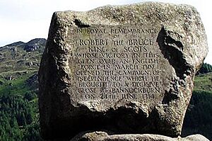
In 1929, on the 600th anniversary of Bruce's death, Bruce's Stone was placed high above Loch Trool. Legend says he commanded the ambush from here. He lived as a fugitive in these hills for about three months. Then he was able to break out and eventually win a much bigger victory at Bannockburn in 1314. This battle gave Scotland some freedom in the first War of Independence.
Robert the Bruce's brother, Edward, had already won a successful campaign against the Comyn family in southwest Scotland before Bannockburn.
Covenanter Fugitives
Throughout most of the 1600s, the Presbyterian Church in Scotland fought against the Stewart Kings. The kings wanted to force Anglican (and sometimes Catholic) practices on the Scottish Church. Presbyterians believed that everyone was equal in God's eyes and could understand the Bible themselves. They felt they didn't need a church hierarchy appointed by powerful people. They believed the English Reformation had just replaced the Pope's power with the king's power over the church. They refused to let the king dictate their religious freedom.
Their beliefs were seen as dangerous by kings who thought they had a divine right to rule. The National Covenant was signed in 1638, and this is where the Covenanters got their name. Southwest Scotland was a strong center of resistance to the kings' religious rules. Both sides went to extreme lengths in this conflict.
The Killing Times
The government used its full power against the Covenanters, who were mostly ordinary people. For a long time, they were hunted in the Galloway Hills, much like Robert the Bruce had been. They were willing to risk quick and brutal execution for their beliefs if caught. Those who died were seen as martyrs. Like Bruce, they were idealists fighting for what they believed in. There were several battles between the Covenanters and the king's forces across Scotland.
However, the Covenanters' struggles to survive in these hills and practice their beliefs (in secret meetings called conventicles) lasted for years, not just months. Eighty-two people were killed by troops during the Killing Time (1684–1685). Since these are only the recorded deaths, the real number could be much higher. Shepherds later found many skeletons of Covenanters who had been killed and left in the hills.
This conflict was finally resolved after the Glorious Revolution of 1688. Under William of Orange, Presbyterianism became the main faith of most Scots. The Presbyterian Church of Scotland was accepted by the authorities.
In the 1700s, a stonemason named Robert Paterson dedicated his life to restoring the monuments of the Covenanter martyrs. Author Walter Scott used him as the model for his character "Old Mortality". The Galloway author S.R.Crockett wrote several novels about the Covenanters set in the Galloway Hills, including The Men of the Moss Hags.
Smugglers and Gypsies
The 1700s were a busy time for smuggling along the Solway coast. This area is only about 20 miles (30 km) from the Isle of Man, which was a main route for illegal goods. The Galloway Hills offered a safe place for these lawless people. They could retreat there when in trouble and use the hills as a safe route for their goods. They would use strings of up to 200 horses to carry smuggled items to Glasgow or Edinburgh.
"Gypsy" or "Tinkler" clans were heavily involved in moving smuggled goods to market. The most famous of these gypsy smugglers was Billy Marshall, known as the "King of the Gypsies." He is said to have fought at the Battle of the Boyne in 1690 at age 18 and died in 1792 at 120 years old, having married 17 times. He was also a leader of the Levellers. The Galloway Levellers were involved in a significant farming rebellion in 18th-century Scotland. They would knock down walls that landowners built to enclose land. The Galloway author S.R.Crockett used the Levellers Rebellion as a sub-plot in his novel The Dark o' the Moon, which is set in the Galloway Hills.
|
 | Selma Burke |
 | Pauline Powell Burns |
 | Frederick J. Brown |
 | Robert Blackburn |


