Loch Valley facts for kids
Quick facts for kids Loch Valley |
|
|---|---|

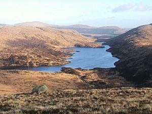
The loch viewed from Buchan Hill, looking east. Loch Narroch is visible at the far end.
|
|
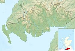
| Location | Galloway, Scotland |
| Coordinates | 55°06′15″N 4°26′20″W / 55.10417°N 4.43889°W |
| Type | freshwater loch |
| Primary inflows | Mid Burn, Loch Narroch |
| Primary outflows | Gairland Burn |
| Basin countries | United Kingdom |
| Surface area | 37.2 km2 (14.4 sq mi) |
| Surface elevation | ~320 m (1,050 ft) |
Loch Valley is a beautiful freshwater loch (that's a Scottish word for lake!) located in the amazing Galloway Forest Park in Scotland. It sits to the east of Buchan Hill and southwest of Craignaw.
Water flows out of Loch Valley through a stream called Gairland Burn. This burn eventually reaches another larger loch called Loch Trool. The area around the loch is part of the Loch Doon granite region.
How Acid Rain Affected Loch Valley
For many years, Loch Valley faced a big problem called acidification. This means the water became too acidic. Acidification often happens because of acid rain. Acid rain is caused by pollution in the air.
The loch started getting more acidic around the mid-1800s. This change was very bad for the fish living there. Sadly, the original population of Brown trout disappeared because the water was too acidic for them to survive.
The Loch's Recovery
Luckily, things have started to get better for Loch Valley. The water's acidity is measured using something called pH. A lower pH means more acid. In 1978, the loch's pH was around 4.4, which is very acidic.
By 2003, the pH had slowly increased to 5.2. This means the water is becoming less acidic. This recovery is good news for the plants and animals that live in and around the loch. It shows that efforts to reduce pollution can help nature heal.
 | Valerie Thomas |
 | Frederick McKinley Jones |
 | George Edward Alcorn Jr. |
 | Thomas Mensah |


