Mullwharchar facts for kids
Quick facts for kids Mullwharchar |
|
|---|---|
 |
|
| Highest point | |
| Elevation | 692 m (2,270 ft) |
| Prominence | 187 m (614 ft) |
| Listing | Ma,Hu,Tu,Sim, G, D,DN,Y |
| Naming | |
| English translation | possibly Scottish Gaelic: Bare Hill of Farquhar |
| Geography | |
| Location | Dumfries and Galloway, Scotland |
| Parent range | Dungeon Hills, Galloway Hills, Southern Uplands |
| OS grid | NX 45419 86634 |
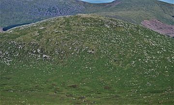
Mullwharchar is a hill found in the Dungeon Hills. This area is part of the larger Galloway Hills range. It belongs to the Southern Uplands of Scotland.
Mullwharchar is located north of Loch Enoch. It sits west of Corserine and northeast of Merrick. To its east is Kirriereoch Hill. The hill has three cliffs called The Slock, The Tauchers, and The Organ Pipes. Some people enjoy climbing routes on these cliffs. The very top of Mullwharchar is quite flat. You can also see large rocks called erratics scattered around. These rocks were left behind by glaciers long ago.
Protecting Mullwharchar
In January 1978, a plan was suggested for Mullwharchar. The UKAEA wanted to drill into the hill. They aimed to see if it was a good place to store certain types of special waste deep underground.
However, many local people were very concerned about this idea. They strongly protested against the plan. On October 24, 1978, the local council, Kyle and Carrick District Council, rejected the application.
The community's protest was very strong. A petition with 100,000 signatures was even sent to the Queen. This showed how many people did not want the drilling to happen. The group that wanted to drill appealed the council's decision. This appeal process cost a lot of money, about £19,700. In the end, the community's efforts succeeded in protecting Mullwharchar from the proposed drilling.
 | Janet Taylor Pickett |
 | Synthia Saint James |
 | Howardena Pindell |
 | Faith Ringgold |

