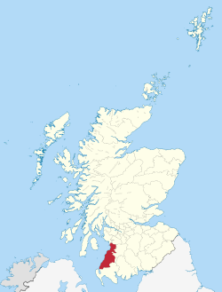
Kyle and Carrick facts for kids
| Kyle and Carrick | |
 Kyle and Carrick District within Scotland |
|
| Geography | |
| Status | District |
| History | |
| Created | 16 May 1975 |
| Abolished | 31 March 1996 |
| Succeeded by | South Ayrshire |
Quick facts for kids Politics |
|
|---|---|
| Governance | Kyle and Carrick District Council |
Kyle and Carrick (Scottish Gaelic: A' Chùil agus a' Charraig) was a special area in Scotland that helped manage local services. It was one of 19 "districts" in the larger Strathclyde region. This system was used from 1975 to 1996. The Scottish Gaelic name for Kyle and Carrick is A' Chùil agus a' Charraig.
Contents
History of Kyle and Carrick
Kyle and Carrick was created in 1975. This happened because of a new law called the Local Government (Scotland) Act 1973. This law changed how local areas were managed across Scotland.
The new system had two levels: larger "regions" and smaller "districts." Kyle and Carrick was one of 19 districts in the Strathclyde region.
Areas that Formed Kyle and Carrick
The Kyle and Carrick district was made up of several smaller areas. These areas were part of the historic county of Ayrshire. They were all combined to form the new district.
Here are the areas that became part of Kyle and Carrick:
- Ayr Burgh (a type of town)
- Ayr District (most of it)
- Part of Dalmellington District (including Coylton)
- Girvan Burgh
- Girvan District
- Maybole Burgh
- Maybole District
- Prestwick Burgh
- Troon Burgh
Borders and Neighbours
Kyle and Carrick shared its borders with several other districts. To its north and east, it bordered Cunninghame, Kilmarnock & Loudoun, and Cumnock and Doon Valley districts. These were all part of the Strathclyde region.
It also bordered Stewartry and Wigtown districts. These two districts were part of the Dumfries & Galloway region.
Key People and Achievements
In 1974, Alistair Irving Haughan became the Chief Architect for the Kyle and Carrick District Council. He held this important job until he retired in 1990.
During his time, the Council worked on restoring a famous bridge. This was the Brig O' Doon in Alloway, known from Robert Burns's poem Tam o' Shanter. The restoration work was so good that it won a special award from the Stone Federation.
End of Kyle and Carrick
The Kyle and Carrick district stopped existing in 1996. This was due to another new law, the Local Government etc. (Scotland) Act 1994. This law changed Scotland's local government again.
The regions and districts were replaced with "unitary council areas." This means each new area managed all local services by itself. The new South Ayrshire council area was created with the exact same borders as the former Kyle and Carrick district.
Political Control of the Council
The first election for the Kyle and Carrick district council happened in 1974. At first, the new council worked alongside the old councils. It officially started its duties on May 16, 1975.
The table below shows which political party was in charge of the council during different periods:
| Party in control | Years | |
|---|---|---|
| Conservative | 1975–1980 | |
| Labour | 1980–1984 | |
| Conservative | 1984–1988 | |
| Labour | 1988–1992 | |
| Conservative | 1992–1996 | |
Council Buildings
The main offices for the Kyle and Carrick district council were in Ayr. They set up their headquarters in a building called Burns House, located in Burns Statue Square. They also had another office in a 19th-century house at 30 Miller Road.
See also
 | John T. Biggers |
 | Thomas Blackshear |
 | Mark Bradford |
 | Beverly Buchanan |

