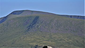
Kirriereoch Hill facts for kids
Quick facts for kids Kirriereoch Hill |
|
|---|---|
 |
|
| Highest point | |
| Elevation | 786 m (2,579 ft) |
| Prominence | 150.2m |
| Listing | Ma,Hu,Tu,Sim, D, CT,DN,Y,xC |
| Naming | |
| English translation | Scottish Gaelic: Hill of the Brindled Quarter |
| Geography | |
| Location | South Ayrshire, Dumfries and Galloway, Scotland |
| Parent range | Range of the Awful Hand, Galloway Hills, Southern Uplands |
| OS grid | NX 42093 86949 |
| Topo map | OS Landranger 77 |
Kirriereoch Hill is a mountain located in the southwest of Scotland. It is part of the Galloway Hills range, which is found within the larger Southern Uplands. This hill sits right on the border between two modern regions: Dumfries and Galloway and South Ayrshire. A special boundary wall near the top of Kirriereoch Hill marks the highest point in all of South Ayrshire.
Contents
What is Kirriereoch Hill?
Kirriereoch Hill is a noticeable peak that stands 786 meters (about 2,579 feet) above sea level. It is part of a group of mountains known as the Range of the Awful Hand. This is a smaller section of the larger Galloway Hills range. The name Kirriereoch comes from the Scottish Gaelic language. It means "Hill of the Brindled Quarter."
Where is Kirriereoch Hill Located?
You can find Kirriereoch Hill in the scenic landscape of Scotland. It is positioned exactly on the border between the historic counties of Ayrshire and Kirkcudbrightshire. Today, these areas are known as South Ayrshire and Dumfries and Galloway. Its location makes it a significant landmark for both regions.
Why is Kirriereoch Hill Important?
Kirriereoch Hill is important because it is the highest point in South Ayrshire. This means that if you are in South Ayrshire, Kirriereoch Hill is the tallest natural spot you can reach. A wall near its summit shows this boundary. This makes it a special place for people who enjoy exploring high points.
Hill Classifications: Marilyn and Corbett
Hills and mountains in the British Isles are often given special classifications based on their height and how much they rise above the surrounding land. Two of these classifications are "Marilyn" and "Corbett."
What is a Marilyn?
A Marilyn is a hill or mountain in the British Isles that has a "prominence" of at least 150 meters (about 492 feet). Prominence means how much a hill rises from the lowest point connecting it to a higher peak. Think of it as how much a hill stands out on its own.
What is a Corbett?
A Corbett is a mountain in Scotland that is between 2,500 and 3,000 feet (762 and 914 meters) high. It also needs to have a prominence of at least 500 feet (152.4 meters). Corbetts are named after John Rooke Corbett, who was the first person to climb all of them.
Kirriereoch Hill's Classification Journey
Kirriereoch Hill has had an interesting journey with these classifications.
- Early Classification: The hill was once listed as both a Corbett and a Marilyn.
- Deletion in 1984: In 1984, Kirriereoch Hill was removed from both lists. This happened because experts thought it did not meet the required prominence criteria.
- Re-listing as a Marilyn in 2015: In August 2015, the hill was surveyed again. This new survey showed that Kirriereoch Hill has a prominence of 150.2 meters. Because this is just over the 150-meter requirement, it was re-listed as a Marilyn.
- Not a Corbett: Even though it is a Marilyn, Kirriereoch Hill will not be re-listed as a Corbett. This is because its prominence (150.2 meters) is slightly less than the 152.4 meters needed to be a Corbett.
 | Kyle Baker |
 | Joseph Yoakum |
 | Laura Wheeler Waring |
 | Henry Ossawa Tanner |

