
Kirkinner facts for kids
Quick facts for kids Kirkinner |
|
|---|---|

Kirkinner
|
|
| Council area | |
| Lieutenancy area | |
| Country | Scotland |
| Sovereign state | United Kingdom |
| Post town | NEWTON STEWART |
| Postcode district | DG8 |
| Dialling code | 01988 |
| Police | Dumfries and Galloway |
| Fire | Dumfries and Galloway |
| Ambulance | Scottish |
| EU Parliament | Scotland |
| UK Parliament |
|
| Scottish Parliament |
|
Kirkinner (Scottish Gaelic: Cille Chainneir) is a small village in the Machars area of Dumfries and Galloway, Scotland. It's located in the historic county of Wigtownshire. The village is about 3 miles southwest of Wigtown. To its east, Kirkinner stretches along the beautiful Wigtown Bay for about three miles. The River Bladnoch forms its northern boundary.
Contents
Exploring Kirkinner's Past
Kirkinner has a long and interesting history, with signs of ancient people living here many centuries ago.
Ancient Forts and Settlements

Near Orchardtown Bay, you can find a place called "Ring Hill." This was once a hill fort, an ancient fortified settlement. Another important site is Doon Hill fort, located west of Barnbarroch. This fort sits on a rocky hill where the ground drops steeply on one side.
Around the edge of this hill, you can still see the remains of a strong stone wall. This wall once enclosed an area about 34 meters long and 30 meters wide. The entrance to the fort was about 4 meters wide and faced southwest. There was also a ditch dug around the base of the hill, except where the slopes were already very steep. This ditch was even cut through solid rock in some places.
St Kennera’s Cross
Just off Kirkinner's main street (the A746 road to Whithorn) stands the parish church of St Kennera. This church, built in the 19th century, is on the site of an even older church from the 13th or 14th century. It might even be where a very early monastic cell existed, home to the 4th-century hermitess, Saint Kennera.
The church is now closed for regular worship. Inside, it used to house a special 4-foot-high cross-slab. This stone dates back to the 10th century AD. It has a beautiful Celtic-style disc-headed cross carved into it. For safety, this important stone has been moved. You can now see it displayed in a special cabinet outside the village hall, right by the main street. The stone slab had stood at the western side of the church for a long time before being brought inside.
The Parish of Kirkinner
You can find maps from the 1650s by Timothy Pont that show the Kirkinner area in Wigtownshire. The National Library of Scotland also has a map by John Ainslie from 1782 that shows the Kirkinner parish. This area was sometimes known as Kirkinner and Longcastle parish. The parish of Longcastle was joined with Kirkinner in 1650. It served as a parish for both local government and religious purposes from the 16th century until 1975.
Kirkinner in Recent Centuries

A place called Castelcruick was located near Crook of Baldoon. This area has been known by several names over time, including Crook, Cruick, and Friar's Cruik. In the 19th century, it was part of the Baldoon estate.
During World War II, the flat lands near the Bladnoch River were home to a Royal Air Force (RAF) airfield. It seems that the Lane Burn, a small stream, was moved to make space for the Baldoon Airfield. This can be seen by comparing old maps from 1895 with current ones.
Kirkinner also had its own railway station. This station was part of the branch line that ran from Newton Stewart to Whithorn. The station first opened on August 2, 1875. It stopped taking passengers on September 25, 1950, and closed completely for freight on October 5, 1964.
Gallery
-
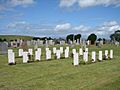
Kirkinner Cemetery - Air Force war graves
-
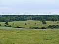
Barnbarroch House
-
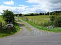
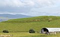
Capenoch Croft near Doon Hill fort
-
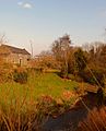
Milldriggan mill, burn and bridge
-
Hill fort, Ring Hill, North Balfern


