
Cruggleton Castle facts for kids
Quick facts for kids Cruggleton Castle |
|
|---|---|
| Cruggleton, Wigtownshire, Dumfries and Galloway, Scotland UK |
|

The castle in 2005
|
|

Cruggleton Castle
|
|
| Coordinates | 54°45′26″N 4°21′26″W / 54.757167°N 4.357333°W |
| Type | Castle |
| Site information | |
| Owner | Private |
| Open to the public |
Yes |
| Condition | Ruined |
| Site history | |
| Built | 13th Century |
| Materials | Stone |
Cruggleton Castle is an ancient site on the coast of the Machars area in southwest Scotland. It's located near Cruggleton Point, about 4.5 kilometers (2.8 miles) east of Whithorn. The castle sits on a high, rocky cliff edge, about 40 meters (130 feet) above the sea. Its name, "Cruggleton," likely comes from the rocky nature of the place.
Archaeologists have dug here and found signs of people living at this spot for a very long time. They found things from the 1st century AD all the way to the 17th century. The first stone tower of the castle was built in the 1200s. It was built on top of an older "motte," which is a raised earth mound.
Contents
A Look Back at Cruggleton Castle's History
This section explores the different times Cruggleton Castle was used and changed. From early settlements to its role in Scottish history, the castle has many stories.
Early Days and First Buildings
Archaeologists found remains of a round hut from the late Iron Age here. They also found a timber hall from the early medieval period. Around the 12th or 13th century, the rocky area was shaped into a "motte," a raised mound of earth. A wooden tower was then built on top of this mound.
At this time, Cruggleton Castle might have been home to the powerful Lords of Galloway. Later, it may have passed to the Earls of Buchan. The first stone tower and a strong outer wall were built between the late 1200s and early 1400s.
Battles and Changes of Ownership
In the 1290s, a nobleman named John Comyn, Earl of Buchan, got permission to dig for lead. He used this lead to cover eight towers of the castle. Cruggleton Castle was sometimes called "The Black Rock of Cree." Some stories say that the Scottish hero William Wallace captured a stronghold near the River Cree, and this might have been Cruggleton.
Scottish forces took the castle again in 1307 and then destroyed parts of it. Later in the 1300s, King David II of Scotland gave Cruggleton to Gilbert Kennedy. In 1424, the castle was given to the Whithorn Priory, which was a religious house.
Royal Visits and Later Years
In 1563, spies from Queen Elizabeth I of England visited southwest Scotland. They checked the defenses of several castles, including Cruggleton. They noted that only two men guarded Cruggleton, but when the head of the Whithorn Priory stayed there, up to 20 men would be present. The spies even drew a picture of the castle, which is now in the British Museum. It shows a tall tower with strong walls, a drawbridge, and a portcullis (a heavy gate).
After the Scottish Reformation, when church lands were given to nobles, there was a disagreement over Cruggleton Castle. Lord Robert Stewart, who was in charge of Whithorn Priory, and John Fleming, 5th Lord Fleming, argued about who owned it. In 1569, Lord Fleming even surrounded the castle where Stewart was staying. Another nobleman, James Stewart, 1st Earl of Moray, helped solve the problem. The castle eventually went to Margaret Stewart in the 1580s.
Cruggleton was later owned by Sir Patrick Vaus, who died in 1598. It then passed through several owners. By 1684, the castle was described as "wholly demolished and ruinous," meaning it was completely broken down and in ruins.
Exploring the Cruggleton Castle Ruins Today
You can reach Cruggleton Castle by following a path along the coast from nearby Galloway House. Today, not much of the castle remains. You can see a small part of a curved stone ceiling, called a "barrel vault," which was once part of the tower. Locals call this "The Arch." It's about 3 meters (10 feet) tall and can be seen from the B7063 road.
You can also see the outlines of where other buildings once stood. The shape of the old "motte" (the raised mound) is still clear, measuring about 31 by 29 meters (102 by 95 feet). There's also a wide ditch that crosses the land, about 50 meters (164 feet) west of the ruins. These remains are protected as a scheduled monument.
Cruggleton Church: A Nearby Landmark
Cruggleton Church is located about 750 meters (about half a mile) west of the castle. This church might show where the old village of Cruggleton used to be. It was built in the early 1100s by Fergus of Galloway, a powerful lord. It is one of the most complete Romanesque churches in the area, known for its rounded arches and thick walls.
The church was restored in the 1890s by William de B M Galloway for the John Crichton-Stuart, 3rd Marquess of Bute. It is now a very important historical building. An ecumenical service, which means a service for different Christian groups, is held in the church every September.
Images for kids
-
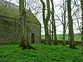
Cruggleton Church south side.
-
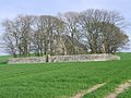
Cruggleton Church.
-
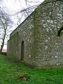
Cruggleton Church, north facing side.
-
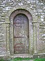
Cruggleton Church door.


