Isle of Whithorn facts for kids
Quick facts for kids Isle of Whithorn |
|
|---|---|
 |
|
| Population | 300 (2001 Census) |
| OS grid reference | NX479273 |
| Council area | |
| Lieutenancy area | |
| Country | Scotland |
| Sovereign state | United Kingdom |
| Post town | NEWTON STEWART |
| Postcode district | DG8 |
| Dialling code | 01988 |
| Police | Dumfries and Galloway |
| Fire | Dumfries and Galloway |
| Ambulance | Scottish |
| EU Parliament | Scotland |
| UK Parliament |
|
| Scottish Parliament |
|
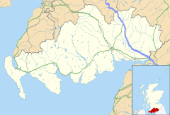
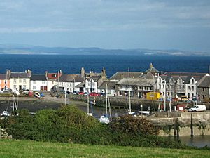
Isle of Whithorn (called Port Rosnait in Gaelic) is a small village and seaport in Scotland. It's one of the most southerly places in the country. You can find it on the coast, about three miles from Whithorn and thirteen miles south of Wigtown in Dumfries and Galloway. People often confuse it with the town of Whithorn, but they are different places. Locals usually just call it 'The Isle'.
The village is home to the old Saint Ninian's Chapel, which was built in the 1200s. It was a special stop for pilgrims (people on a religious journey) who landed on Isle Head and walked to Whithorn. Even though it's not a real island anymore, old maps from the 1700s and 1800s show it as one. The main street used to be a raised path, and the harbour was on what was then the actual island.
People have lived in the Isle of Whithorn for a very long time. Surveys of the land have found old stone piles and farming marks, showing that people lived and farmed here centuries ago.
Contents
Community Life and Fun Things to Do
The village has a local council that helps run things. There's a Church of Scotland church, which used to be called a Free Kirk. It sits right by the harbour.
For fun, there's a bowling club, a simple football field, and two play areas for younger kids. The village hall is a busy place! In 2008, the community took over the hall and made it new again. It's now home to 'Machars Movies', which is Scotland's most southerly cinema. In 2014, a new tearoom, post office, and gift shop called 'Saint Ninian's' opened next to the hall.
The Isle has one pub called the Steam Packet Inn. Another pub, the Queen's Arms, closed down and is now an art gallery and craft shop. Near the harbour, you'll find Isle Sea Foods, a fish shop and general store. Upstairs, there's a launderette, toilets, and showers. The old village school is now a private house.
At the north end of the village, there's a granite war memorial. It remembers twelve local people who died in the First World War and five who died in the Second World War.
Outdoor Adventures
If you love the outdoors, there's lots to do! You can go fishing in the local lochs (lakes), rivers like the Bladnoch and Cree, or out at sea. There are many quiet paths and roads perfect for walking, horse riding, or cycling.
The Pilgrim's Way is a special walking route that goes south from the Southern Upland Way. It passes through places like New Luce, Glenluce Abbey, and Whithorn, ending at the Isle of Whithorn and St Ninian's Cave. The main part of this route is about 25 miles (40 km) long.
A Glimpse into History
The Isle of Whithorn has a rich history. An ancient writer named Pliny the Elder (who died in AD 79) described Britain and its islands. One of these islands, vectis, is thought to be the Isle of Whithorn. Another old name, Lucopibia, also seems to be linked to Whithorn.
This area was once a popular spot for smugglers, who illegally brought goods into the country. But it was also a very important harbour for legal trade and travel. From here, you could catch the Countess of Galloway, a steam packet ship that would take you to Liverpool. From Liverpool, many people would then travel to the New World (America) or Australia.
Isle Castle
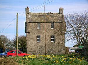
The Isle Castle is one of the oldest buildings in the village. It's quite small and almost square. In the early 1800s, it was home to the head of the Coastguard, Sir John Reid. The 'Captain's Garden' was originally a garden connected to the castle. It now has houses on it, but it's still called the Captain's Garden. It even has decorations that look like old warship gun ports!
Above a door, you can see a stone with the initials of Patrick Houston of Drummaston and his wife Margaret Gordon. It also shows the likely building date of 1674. This stone used to be on the main entrance of the castle.
Near the castle, there was once a corn mill called Bysbie. It used water power from a large mill pond. You can still see the remains of the mill behind the Queen's Arms Hotel.
St Ninian's Chapel
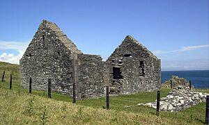
The chapel was repaired and partly rebuilt in 1898. Its main parts were kept the same. The ruins you see today are rectangular, measuring about 31 feet by 16.5 feet (9.4 m by 5.0 m) inside. This building likely replaced an older chapel from the 1100s or early 1200s. The foundations of that older chapel were found during digs.
The chapel was inside a wall, and part of that wall is still standing. There might have been an even older, outer wall from the Celtic period. There are no records that the chapel was used as a burial ground.
St Ninian is mostly remembered in Whithorn. However, many places in Scotland are named after him, like Saint Ninian's Isle. He helped convert the Southern Picts to Christianity, so he traveled through many parts of southern Scotland.
The Cairn
The most famous landmark in the Isle is a square, white tower known as 'The Cairn'. It has helped ships navigate for hundreds of years.
From here, you can see amazing views of the Kirkcudbright coast, the mountains of the English Lake District, and the rounded mountains of the Isle of Man to the south.
During the Second World War, The Cairn was used as a tracking station for anti-aircraft gun practice. Planes would fly by, and the guns would try to shoot them down. They even used radio-controlled 'Queen Bee' aircraft. The flat concrete area by the white tower was for one of the control huts. Today, this spot has a memorial stone for the Solway Harvester, which is an anchor set in a granite block.
Isle Head
This piece of land sticking out into the sea is called Isle Head. It's almost cut in half by two bays, Chapel Port east and west. You can still clearly see the old ditch of the Old Fort as you approach Isle Head.
There's an ancient promontory fort on Isle Head. It has three walls and two ditches, and possibly a fourth wall that is now very small. On the side facing the sea, there are parts of old stone walls that used natural rocks. In the southeast corner, you can see the base of a wall that was up to 3 yards wide. On the flat top of the hill, there are signs of old walls and possibly the remains of a hut circle (an ancient circular house).
You can also see old farming marks on Isle Head, between the path and the walls of the Iron Age fort. These marks show where crops were grown.
In 1997, a special stone pile (cairn) was built to remember when the Christian missionary St. Ninian arrived here. Pilgrims are encouraged to place stones with personal messages onto a rock cairn. These cairns are located in the remains of a building that used to house the Isle of Whithorn lifeboat.
The lifeboat station was set up in 1869. It had a roof until after the Second World War, even though the station closed in 1919. During its 50 years of operation, three lifeboats served here:
- Charlie Peake (1869–1886): 7 launches and 10 lives saved.
- Henry and John Leighton (1886–1901): 12 launches and 22 lives saved.
- George and Margaret (1901–1919): 6 launches and 6 lives saved.
The Solway Harvester Seat is a granite bench. It's one of two local memorials to the seven local crew members of the fishing boat Solway Harvester. The boat sank in a storm off the Isle of Man in January 2000. The other memorial, an anchor in a stone, is on top of the nearby hill next to The Cairn.
The Harbour
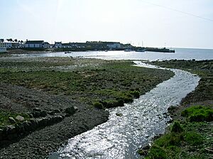
The harbour is still the main heart of the village. The local fishing boats here catch lobsters and do light trawling (a type of fishing). Many leisure boats are kept here, and the Isle is becoming a popular stop for pleasure boats sailing along the west coast. It's also a good place to launch small fishing boats and diving boats from trailers.
The first pier was built in the 1500s. A bigger one was built in 1790 to help with trade, like with Whitehaven and other English ports. In 1969, a storm badly damaged the pier. It was only rebuilt after local people campaigned for a long time. There's a rocky reef called the "perch" at the mouth of the bay. It can be dangerous for boats coming into the Isle. For many years, an iron pole marked its end.
In the 1800s, the Isle also had strong trade links with Ireland and the Isle of Man. Ships were built and sailed from here. The Countess of Galloway, a steam packet ship, used to sail regularly from here to Liverpool. By the end of the 1900s, trading ships were mostly replaced by yachts and other leisure boats.
The Wigtown Bay Sailing Club welcomes all visiting sailors. Their clubhouse is on the harbour and has all the usual facilities. The harbour dries out (becomes shallow) three hours before and after high tide. There's a special spot for visitors' boats at the end of the quay. There are also two slipways for launching boats. One is at the inner end of the quay and is protected from bad weather. The other, which goes into the bay, can be used at almost any tide level. The club is active all summer, with races most weekends and some during the week.
An interesting old feature of the harbour was a fish trap. This was a wall across part of the upper inlet that would trap fish as the tide went out. It was still marked on maps as late as the 1850s.
The Wicker Man
Parts of the 1973 horror film The Wicker Man were filmed in and around Isle of Whithorn. The exciting ending of the film was shot at St Ninian's Cave and on the cliffs at Burrow Head. The co-owner of the Isle of Whithorn castle, Elizabeth McAdam Laughland, and several other local people appeared in different scenes of the movie.
 | Valerie Thomas |
 | Frederick McKinley Jones |
 | George Edward Alcorn Jr. |
 | Thomas Mensah |


