Knott, Caldbeck facts for kids
Quick facts for kids Knott |
|
|---|---|

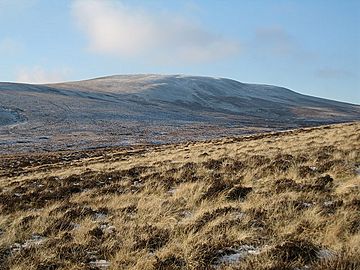
Knott from Lingy Hut
|
|
| Highest point | |
| Elevation | 710 m (2,330 ft) |
| Prominence | 242 m (794 ft) |
| Parent peak | Skiddaw |
| Listing | Marilyn, Hewitt, Wainwright, Nuttall |
| Geography | |
| Location | Cumbria, England |
| Parent range | Lake District, Northern Fells |
| OS grid | NY296329 |
| Topo map | OS Landrangers 89, 90 |
Knott is a mountain located in the northern part of the English Lake District. It is the highest point in a wild, quiet area known as the Back o'Skiddaw. This region is found north of the famous mountains Skiddaw and Blencathra. Other peaks in this area include High Pike, Carrock Fell, and Great Calva. Knott's slopes are mostly smooth and covered in grass, with some deep ravines. It is quite far from any roads, so reaching it requires a long walk across the moorland. Because it is hidden by two larger mountains, Knott is one of the least visited peaks in the Lake District. People usually climb it from Mungrisdale or from the north via Great Sca Fell. The name Knott comes from an old local language and simply means "hill."
Contents
Exploring Knott's Shape and Surroundings
What is the Back o'Skiddaw?
Skiddaw and Blencathra are very well-known mountains in the Northern Fells. They stand tall, looking over Keswick and the road to Penrith. Behind these big mountains is another group of fells, often called the Back o'Skiddaw. Knott is right in the middle of this group and is its highest point.
The Back o'Skiddaw group is separated from Blencathra and the Skiddaw area by Skiddaw Forest. This "forest" is a bit confusing because it has no trees! Instead, it's a marshy, high-up area about 1,300 feet (396 meters) high. It is surrounded by higher fells on all sides. Three main streams flow from Skiddaw Forest. These streams divide the Northern Fells into three different sections. Dash Beck flows to the north-west, the River Caldew flows to the north-east, and the River Glenderaterra flows south, between Skiddaw and Blencathra.
Knott's Unique Features
Knott itself is a long, rounded ridge that stretches for three miles (about 5 kilometers) from east to west. Most of the fell has wide, gentle slopes covered mainly in grass. Many streams that flow down Knott's sides have cut deeply into the land. This has revealed yellow and red soils, which you can see from far away.
The western end of the fell is called Burn Tod. It slopes down between Burntod and Hause Gills. These are both small streams that flow into Dash Beck. To the north is a shorter, parallel ridge called Frozen Fell. These two parts are the only areas of Knott that drain westward towards the River Derwent.
From the south side of the summit, a ridge goes down to a narrow dip. This dip connects Knott to the nearby fell of Great Calva. Another part of Knott on this side, further to the east, is named Snab. Wiley Gill and Burdell Gill are streams that flow down this side into the River Caldew. The Caldew eventually joins the River Eden near Carlisle.
The eastern end of the summit ridge is Coomb Height. At the bottom of this slope, in a rough area, you can find the remains of the old Carrock Fell Mine. Coombe Height is bordered by Wet Swine Gill and Grainsgill Beck. These are more streams that flow into the River Caldew.
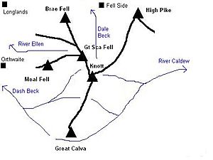
Two connecting ridges stretch north from Knott. They are separated by the deep valleys of Roughton Gill. The western ridge goes down across a boggy area. It then reaches the top of Great Sca Fell without much of a climb. The eastern ridge crosses Miller Moss and then stays high for two miles (about 3 kilometers) to High Pike. Along the way, it passes over smaller tops called Great Lingy Hill and Harestones.
Miller Moss: A Newly Recognized Mountain
In August 2018, it was announced that Miller Moss, also known as Little Lingy Hill, had been re-measured. It was found to be 610.1 meters (2,002 feet) high. It also had a prominence of 19.7 meters (65 feet). This new measurement meant it could be officially called a mountain. It was then added to the list of Nuttalls.
Reaching the Summit of Knott
Wainwright, a famous fell walker, once wrote about Knott's summit. He said that if you were with friends and had a bat, ball, and wickets, you could play a cricket match there. He thought the grass was good enough for a county ground! On the grassy top, there is a pile of stones called a cairn. Other stone markers are on top of Coomb Height, Burn Tod, and Snab. However, the main ridge top is mostly flat and open, and the paths are hard to see.
The view to the south is partly blocked by Blencathra and Skiddaw. But between them, you can see a small part of the central Lake District. This includes a distant view of Thirlmere lake and the Scafells. To the north, you can see the Solway Firth and the hills of south-west Scotland. The area right in front of you is not very exciting.
You can see a computer-generated view from the summit here: Computer-generated summit panorama
Mining History Near Knott
Although most of the Carrock Fell Mine is under Carrock Fell, some parts are located south of Grainsgill Beck. These are at the base of Coomb Height. A long ditch runs north down the slope to the beck. It contains several shafts (deep holes) and levels (tunnels). These surface workings follow the Harding Vein, which was the most productive part of the mine. Carrock Fell Mine was the only place in Britain outside Cornwall where Tungsten was mined. It operated at different times between 1850 and 1982, whenever the price of Tungsten was high enough. Even though there are still believed to be reserves of Wolframite and other tungsten ores, the Harding vein under Knott has been fully mined out. The old tunnels were later used to dump waste from processing the ore.
There was also a small mining operation on the southern side of Knott called Little Wiley Gill Mine. A 40-yard (37-meter) tunnel was dug here, but not much other information about it remains.
How to Climb Knott
You can start your climb from Orthwaite, to the north-west. From there, you can follow a track to the source of Hause Gill. This track leads to the col (a low point between two peaks) between Knott and Great Calva. Another starting point is Longlands. From here, you cross the ridge between Meal Fell and Great Cockup. Then, you follow a path up between Burn Tod and Frozen Fell.
Fell Side offers access from the north. You can use the old mine track next to Roughten Gill. Once you reach the mine, you can climb to the summit even if there isn't a clear path.
The road that leads to Carrock Fell Mine can also be used to get onto Coomb Height. This is a way to start your climb from Mosedale. However, Wainwright gave strong warnings about the old mine workings on this route, so it's important to be careful.
 | Bessie Coleman |
 | Spann Watson |
 | Jill E. Brown |
 | Sherman W. White |


