Great Calva facts for kids
Quick facts for kids Great Calva |
|
|---|---|

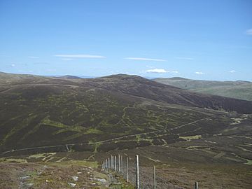
Seen from Birkett Edge on Bakestall, 2 km to the west. The track to Skiddaw House runs along the base of the fell.
|
|
| Highest point | |
| Elevation | 690 m (2,260 ft) |
| Prominence | c. 142 m |
| Parent peak | Knott |
| Listing | Wainwright, Hewitt, Nuttall |
| Geography | |
| Location | Cumbria, England |
| Parent range | Lake District, Northern Fells |
| OS grid | NY291312 |
| Topo map | OS Explorer OL4 |
Great Calva is a cool mountain, also known as a fell, located in the amazing Lake District in England. It sits right in the middle of the Northern Fells, which is a group of high mountains. Because of its central spot, it's quite far from any roads. This makes it feel very wild and remote!
Great Calva is also special because it's at the start of a huge crack in the Earth's crust, called a geological fault. This fault runs right through the Lake District. From the top of Great Calva, you can see all the way south over Thirlmere, a beautiful lake. There's also a smaller peak nearby called Little Calva, which is to the west.
Contents
Discovering Great Calva and Its Neighbors
Skiddaw and Blencathra are two of the most famous mountains in the Northern Fells. They stand tall near Keswick and the road to Penrith. Behind these big mountains is another group of fells often called "Back o' Skiddaw." Great Calva is the southernmost mountain in this group.
The Mystery of Skiddaw Forest
South of Great Calva, right in the heart of the Northern Fells, is a place called Skiddaw Forest. But don't let the name fool you! This "forest" doesn't have any trees. It's actually a marshy, high-up area about 1,300 feet above sea level. It's surrounded by taller mountains on all sides.
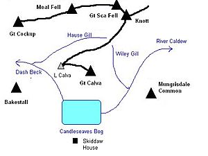
Three streams start in Skiddaw Forest. These streams divide the Northern Fells into three main areas. Dash Beck flows to the northwest, the River Caldew flows to the northeast, and the River Glenderaterra flows south. These streams help us think of the fells in three groups: the Skiddaw mountains, the Blencathra group, and the Back O'Skiddaw fells.
The only building in Skiddaw Forest is Skiddaw House. This building has been used for different things over the years. It was once a shelter for shepherds and even a Youth Hostel where young travelers could stay.
Great Calva's Shape and Surroundings
From Skiddaw Forest, Great Calva looks like a steep-sided pyramid. It's mostly covered in purple heather, which is a type of plant. The very top of Great Calva is a long, curved ridge about half a mile long. Great Calva itself is at the eastern end of this ridge, and Little Calva is at the western end.
Walking along this ridge can be very wet underfoot! Between the two tops, a stream called Dead Beck flows down into Candleseaves Bog. This bog is where both the River Caldew and Dash Beck begin. Great Calva also has a noticeable ridge sticking out to the south. The River Caldew flows around this ridge before heading northeast towards the Eden Valley.
Connecting Peaks and Waterfalls
A ridge runs northeast from Little Calva, dropping down to a low point called a col at 1,797 feet. From there, the land rises up towards Knott mountain. You can find a couple of small tarns (which are small mountain lakes) on the Great Calva side of this dip. From the col, Wiley Gill flows southeast to join the River Caldew, and Hause Gill flows west to Dash Beck.
Little Calva also has another ridge that goes down to the northwest, right next to Dash Beck. There are several smaller ridges called Black Nettle Hause, Little Nettle Hause, and White Hause that drop towards the river. Between Black Nettle Hause and Birkett Edge on Bakestall, Dash Beck creates a beautiful series of waterfalls called Whitewater Dash.
Reaching the Top of Great Calva
What You'll Find at the Summit
At the very top of Great Calva, you'll see a cairn (a pile of stones) on the south ridge. There's another cairn a little further north, which marks the highest point. You might also notice the remains of an old fence connecting the two. Just a few steps east of the highest point, there's a stone shelter built to protect you from the wind. While there are some rocks, the top is mostly covered in grass and heather.
The Amazing Views
The view from the top of Great Calva, especially from the lower cairn, is surprisingly good! If you look straight down the Glenderaterra Valley and the Vale of St John, you'll have a clear view all the way to Loughrigg and Steel Fell. You can also spot Great Gable and the Scafells (some of the highest mountains in England) peeking out above the slopes of Lonscale Fell. However, the mountains closer to Great Calva block some of the view to the north, so that direction isn't quite as exciting.
How to Climb Great Calva
Walking on Great Calva can be a bit tricky because it's mostly covered in thick heather. One way to climb it is from the northwest, starting from Orthwaite. You can follow a bridleway (a path for horses and walkers) between Great Cockup and Little Calva. This path leads you to the low point between Knott and Great Calva's summit.
Another option is to climb the pathless south ridge from Skiddaw Forest. This gives you several choices for where to start your adventure. You can follow the supply road for Skiddaw House, which goes up Dash Beck from Peter House Farm. Or, there's a good track that runs alongside the River Caldew from the road at Mosedale. You can also reach Great Calva by walking up the Glenderaterra valley from the south. You can start either from the Gale Road car park or near Threlkeld.
 | Anna J. Cooper |
 | Mary McLeod Bethune |
 | Lillie Mae Bradford |


