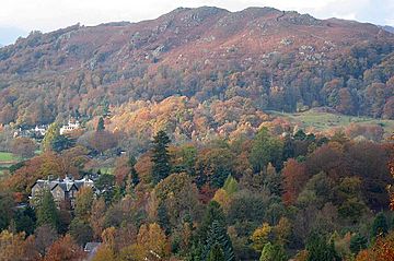
Loughrigg Fell facts for kids
Quick facts for kids Loughrigg Fell |
|
|---|---|
 |
|
| Highest point | |
| Elevation | 335 m (1,099 ft) |
| Prominence | c. 172 m |
| Parent peak | High Raise |
| Listing | Marilyn (hill), Wainwright |
| Naming | |
| English translation | Small rocky hill of the lake |
| Language of name | English, Irish |
| Geography | |
| Location | Cumbria, England |
| Parent range | Lake District, Central Fells |
| OS grid | NY347051 |
| Topo map | OS Landranger 90 |
Loughrigg Fell is a beautiful hill located in the central part of England's famous Lake District. It's like the last stop on a long ridge that stretches from a bigger mountain called High Raise. Loughrigg Fell is separated from its nearby hills by a dip in the land known as Red Bank.
Contents
About Loughrigg Fell
This fell is special because it's surrounded by a lot of water! To the north, the River Rothay flows through two lakes, Grasmere and Rydal Water. This river then curves around the eastern side of Loughrigg.
On the southern side, the River Brathay flows from Elter Water. It also gets water from a small lake called Loughrigg Tarn. These two rivers meet at a place called Clappersgate. From there, they flow into Windermere, which is England's largest natural lake.
The western edge of Loughrigg Fell is marked by Red Bank. This area has many small streams that flow into Grasmere and Elter Water.
Exploring the Slopes
Loughrigg Fell has two smaller ridges on its eastern side. One is called Lanty Scar, which is a clear path if you're walking up from Rydal. Another path, over Todd Crag, leads up from Clappersgate.
The lower parts of the fell are covered in woodlands. As you go higher, you'll find wide areas with bracken (a type of fern), small hills, and tiny lakes called tarns. The very top of the fell is on the western side. You can spot it by an Ordnance Survey column, which is a marker used for mapping.
Even though many lakes surround the fell, only Windermere can be seen from the very top. From the summit, you get great views of the green countryside to the south. You can also see many other fells (hills) in the other directions.
Getting Around Loughrigg
Loughrigg Fell is easy to get to because roads surround it. Towns like Ambleside, Skelwith Bridge, Elterwater, Grasmere, and Rydal are all nearby. There's also a popular car park at White Moss Common.
Many paths crisscross the fell. One famous path is the Loughrigg Terrace. It's a flat path that offers amazing views of Grasmere, Helm Crag, and the Fairfield mountain group.
Just past the eastern end of the Terrace, you'll find some interesting caves. These were created by quarrying, which means people dug out rocks from the hillside. They go about 45 meters (150 feet) into the hill and sometimes have water inside. There are other small mines on the fell too.
What Loughrigg Fell is Made Of
The rocks that make up Loughrigg Fell are quite interesting. Some parts are made of volcanic rock, like hardened ash and small pieces of rock from old volcanoes. Other parts have different types of volcanic rock, including rhyolite and basaltic andesite. The northwestern slopes are covered with loose material left behind by glaciers.
The Summit Views
The highest point on Loughrigg Fell is a rocky knoll. You can easily spot it by an Ordnance Survey triangulation column and a large cairn (a pile of stones). From here, you get close-up views of the Langdale Pikes and the fells around Grasmere. You can also see the Fairfield horseshoe and the Coniston Fells. Plus, you can see Elter Water, Grasmere, and a big part of Windermere.
How to Walk Up Loughrigg Fell
One easy way to climb Loughrigg is from the White Moss car park. This car park is on the A591 road, between Grasmere and Rydal Water. This walk is fairly simple, with about 213 meters (700 feet) of climbing over 2.4 kilometers (1.5 miles).
From the car park, a path goes through woods and leads to Loughrigg Terrace. At the end of the terrace, a path goes steeply up steps to the wide, wavy top area. You can also start your walk from any of the towns around the fell, with many different paths to choose from.
Loughrigg Fell is also part of the Windermere Way. This is a long walking path that goes all the way around Windermere lake.
The very top of the fell is the middle one of three rocky bumps that you can see.
 | Lonnie Johnson |
 | Granville Woods |
 | Lewis Howard Latimer |
 | James West |


