Great Langdale facts for kids
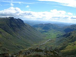
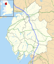
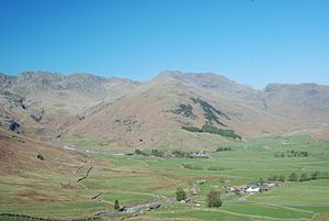
Great Langdale is a beautiful valley located in the Lake District National Park in North West England. It's called "Great" to tell it apart from its smaller neighbor, Little Langdale. There's also another valley named Langdale in the Howgill Fells in Cumbria, so don't get them mixed up!
This valley is super popular with people who love the outdoors, like hikers, climbers, and fell-runners. They come here for the amazing mountains (called fells) that surround the valley. Some of the most famous parts of Great Langdale are the Langdale Pikes, which are a group of peaks on the north side. You can even start a climb to Scafell Pike, England's highest mountain, from Langdale. The valley also offers fantastic views of places like Dungeon Ghyll Force waterfall, Harrison Stickle, and Pike of Stickle.
Long, long ago, during the Neolithic period (the New Stone Age), Great Langdale was a very important place for making stone axes. It was also a center for the Lakeland slate industry, which is all about getting slate from the ground.
Contents
History of Great Langdale
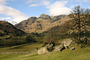
Great Langdale is famous among archaeologists because it was a major source of a special kind of polished stone axe head during the Neolithic period. These axes were made on the slopes of the Pike of Stickle and then traded all across ancient Great Britain and Europe. The area also provided stone for some items during the Bronze Age, like stone wrist-guards. You can still find ancient cup and ring marks (old carvings) on the Langdale Boulders at Copt Howe.
Geography of the Valley
The entrance to the valley is at Skelwith Bridge, which is about two miles west of the town of Ambleside. Inside the Langdale valley, you'll find two villages, Chapel Stile and Elterwater, and a tiny settlement called a hamlet at High Close. Great Langdale itself is a U-shaped valley, which means it was carved out by huge glaciers long ago. Little Langdale, on the other hand, is a hanging valley, which is a valley that sits higher up on the side of a main valley.
Industries of Langdale
Great Langdale and Elterwater were important centers for the Lakeland slate industry. Two slate quarries, Elterwater Quarry and Spout Cragg Quarry, have been working almost continuously using modern methods. Elterwater is the bigger one, and both are run by the Burlington Stone company. There are also many other old quarries in the area that are no longer used, like Lingmoor, Banks, Thrang Crag, and Colt Howe.
The area was also home to a very busy stone axe industry during the Neolithic period. The rocks here are a fine-grained type of greenstone that was perfect for making polished axes. These axes have been found all over the British Isles, showing how important this industry was. The stone was either quarried directly or collected from the loose rock (called scree slopes) on Harrison Stickle and Pike of Stickle.
The Langdale Pikes
The Langdale Pikes are some of the most well-known features of Great Langdale. They are a group of peaks located on the northern side of the valley. From below, they look like a sharp, rocky ridge. However, they are only steep on their southern side; to the north, the land slopes gently up to High Raise, which is the highest peak in this range. The Pikes themselves include (from west to east) Pike of Stickle, Loft Crag, Harrison Stickle, and Pavey Ark.
Pike of Stickle
Pike of Stickle, sometimes called Pike o’ Stickle, reaches a height of 709 metres (2,326 feet). The top of the peak is wide enough for a good-sized pile of stones (called a cairn) and a small flat area. From here, you can see amazing views of Loft Crag and Gimmer Crag nearby, and Bowfell across Langdale. You can also see a large part of the Southern Fells, and even distant Skiddaw on a clear day.
Loft Crag
Loft Crag is 682 metres (2,238 feet) high. It sits between Harrison Stickle and Pike o’ Stickle, and people often climb it along with those two peaks. The fell has a small, sharp top. Below it is Gimmer Crag, which is one of the best places for rock climbing in the Lake District. This crag is made of Rhyolite rock.
Harrison Stickle
Harrison Stickle is the highest point of the Langdale Pikes. Its rocky cliffs drop steeply to the south and east, creating a stunning view from the valley floor 2,000 feet below. To the north, the main ridge of the central fells goes over Thunacar Knott before climbing to High Raise. The steep eastern face of this ridge continues north to Harrison's neighbor, Pavey Ark, which is visually the most impressive cliff in the area.
The southwestern edge of Harrison Stickle is formed by the deep ravine of Dungeon Ghyll. Below the steep eastern face of Harrison Stickle are Stickle Tarn and its Ghyll (a narrow valley or ravine). This means all the water from the fell drains into Great Langdale. The tarn is a lake in a corrie (a bowl-shaped hollow) about 50 feet deep, and it has a small dam to hold more water. The water from the tarn is used for drinking by people in Great Langdale.
Pavey Ark
Pavey Ark is 700 metres (2,297 feet) high. Its main face is a little over a quarter of a mile wide and drops about 400 feet. To the southwest, it joins the cliffs of Harrison Stickle. Stickle Tarn is completely within the area of Pavey Ark. This tarn has been dammed to hold more water. The stone dam is low enough that it doesn't spoil the natural look of the lake. The water from the tarn is used for drinking in the hotels and homes below. The tarn is about 50 feet deep.
Other Fells to Explore
Great Langdale's highest mountain is Bow Fell. Other important fells in Langdale include Crinkle Crags, which is at the head of the Oxendale valley, and Pike o' Blisco on the southern side of the valley.
Dungeon Ghyll and Waterfalls
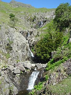
Dungeon Ghyll is a ravine on the north side of the valley. It starts on the slopes between Harrison Stickle and Loft Crag/Pike o' Stickle. It's very narrow, and walkers cannot go all the way through it. Much more open is Stickle Ghyll, which flows down from Stickle Tarn. There's a well-used path from the Stickle Ghyll car park (across from the New Dungeon Ghyll hotel) up to the tarn. Parts of this path have been improved with stone slabs to stop erosion. Another waterfall, called Dungeon Ghyll Force, can be found up a path behind the Old Dungeon Ghyll hotel.
Middle Fell Bridge, located here, was a central part of the plot in the famous 1945 film Brief Encounter.
Tourism and Activities
Great Langdale is a fantastic place for fell walking. Popular routes include climbing Bowfell, Crinkle Crags, the Langdale Pikes, and even England's highest mountain, Scafell Pike. There are also great spots for rock-climbing right on the valley floor, such as Raven Crag, Gimmer Crag, and White Ghyll. These offer some of the most exciting rock-climbing routes in the UK.
The Langdale Leisure Limited company, which includes a hotel, timeshare lodges, and leisure facilities, operates in the valley, offering places to stay and relax.
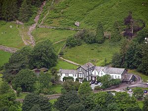
Old Dungeon Ghyll Hotel
The Old Dungeon Ghyll Hotel was originally a farm and an inn. It was bought by the historian Professor G.M. Trevelyan, who then gave it to the National Trust. This hotel and its Hikers Bar have a long history with climbing, and many famous climbers have stayed there. In climbing circles, it's often called the "ODG." Further down the valley, you'll find the New Dungeon Ghyll hotel, which was built in 1862. If you like camping, there are campsites in the area, including a National Trust site near Dungeon Ghyll and the Baysbrown Farm campsite at Chapel Stile.
 | May Edward Chinn |
 | Rebecca Cole |
 | Alexa Canady |
 | Dorothy Lavinia Brown |


