Harrison Stickle facts for kids
Quick facts for kids Harrison Stickle |
|
|---|---|

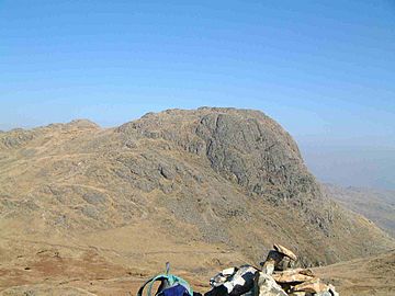
Harrison Stickle seen from Loft Crag
|
|
| Highest point | |
| Elevation | 736 m (2,415 ft) |
| Prominence | c. 53 m |
| Parent peak | High Raise |
| Listing | Hewitt, Wainwright, Nuttall |
| Geography | |
| Location | Cumbria, England |
| Parent range | Lake District, Central Fells |
| OS grid | NY281074 |
| Topo map | OS Explorer OL6 |
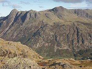
Harrison Stickle is a cool fell (that's a type of mountain or hill) in the middle of England's Lake District. It stands tall above a beautiful valley called Great Langdale. It's one of the famous Langdale Pikes, a group of three (or maybe more!) amazing fells. The other main ones are Pike of Stickle and Loft Crag. These fells together form one of the most beautiful and well-known mountain groups in the entire Lake District. Did you know that a "stickle" is a word for a hill that has a noticeable rocky top?
What Does Harrison Stickle Look Like?
The Langdale Pikes create a rocky wall around the southern and eastern edges of a high, flat area called Thunacar Knott. Harrison Stickle is the highest point of this rocky wall. Its steep cliffs drop down to the south and east from the top, making it look really impressive from the valley floor, which is about 2,000 feet below! You can even see it clearly from far away.
To the north, the main ridge of the central fells goes over Thunacar Knott before climbing up to High Raise. The rocky eastern side of this ridge continues north to Harrison's close neighbor, Pavey Ark. Pavey Ark has the most visually stunning rock face in this whole area.
The south-western edge of Harrison Stickle is marked by a deep, narrow valley called Dungeon Ghyll. This ghyll (which is a steep-sided valley or ravine) cuts through the Langdale Pikes' rocky wall and into the lower area of Harrison Combe. On the other side of the ghyll, to the west, you'll find Thorn Crag, Loft Crag, and finally Pike of Stickle.
Below the steep eastern side of Harrison Stickle lies Stickle Tarn and its own ghyll. This means all the water flowing off the fell ends up in Great Langdale. A tarn is a small mountain lake, and Stickle Tarn is about 50 feet deep. It has a small dam that makes it even deeper. The water from this tarn is used for drinking by people in Great Langdale.

The Rocks and History of Harrison Stickle
The top part of Harrison Stickle is made of a type of rock called pebbly sandstone and breccia. Sandstone is made from grains of sand stuck together, and breccia is a rock made of sharp, broken rock pieces cemented together.
Long, long ago, in the Neolithic period (which was the New Stone Age), people found special green-colored rocks called greenstone near Harrison Stickle. They used these rocks to make tools, especially axes! These axe-making places are often called the Langdale axe industry.
People would roughly shape the axes right there on the mountain. Then, they would trade these partly finished axes all across the country. For example, polished axes made from this rock have been found as far away as Buckinghamshire and East Anglia! The axes came in many different sizes and shapes, and most were designed to have wooden or bone handles attached to them.
Reaching the Top of Harrison Stickle
The very top of Harrison Stickle is a short, rocky ridge. You'll find a small pile of stones (called a cairn) at each end of the ridge, with the one on the northern side being a bit higher. The view from the top of Harrison Stickle is amazing! You can see almost all the other major mountain groups in the Lake District from there. It's pretty cool when the view from a mountain is just as good as the view of it!
Most people start their climb from the New Dungeon Ghyll Hotel in Great Langdale. There are a few ways to get up. One simple path follows Stickle Beck (a small stream) up to Stickle Tarn. From there, another path goes up the western side of Pavey Ark to reach the summit. People often combine climbing Harrison Stickle with other nearby peaks to make a longer, circular hike.
 | Shirley Ann Jackson |
 | Garett Morgan |
 | J. Ernest Wilkins Jr. |
 | Elijah McCoy |


