Stickle Tarn, Langdale facts for kids
Quick facts for kids Stickle Tarn |
|
|---|---|

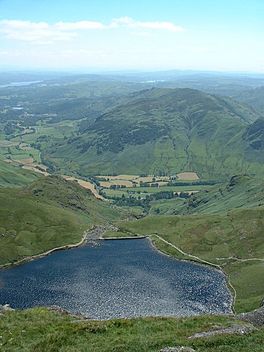
Stickle Tarn from above
|
|
| Location | England |
| Coordinates | 54°27′31″N 3°6′9″W / 54.45861°N 3.10250°W |
| Type | tarn (lake) |
| Basin countries | United Kingdom |
| Max. depth | 50 ft (15 m) |
| Surface elevation | 473 m (1,552 ft) |
| Islands | 2 |
Stickle Tarn is a small mountain lake, also known as a tarn. You can find it near a mountain called Harrison Stickle in the beautiful Lake District area of England.
Discover Stickle Tarn
Stickle Tarn is not just a natural lake. It was made bigger in 1838 when a stone dam was built. This dam helps to hold more water. The water from the tarn is used to supply people living in the nearby area of Great Langdale.
What is a Tarn?
A tarn is a lake that forms in a corrie. A corrie is a bowl-shaped hollow in the mountainside. It is often created by glaciers. Stickle Tarn sits in a corrie. It has Harrison Stickle mountain on its west side. To the north, you can see the huge rock face of Pavey Ark.
Exploring the Area
Many people love to visit Stickle Tarn. It's a popular spot for fellwalking, which is a type of hiking in the mountains. Hikers often pass by the tarn on their way to the top of Pavey Ark. It's also a common path for those heading to High Raise from Great Langdale.
Who Owns Stickle Tarn?
In February 2015, Stickle Tarn was put up for sale. The Lake District National Park Authority decided to sell it. They wanted to reduce the amount of land they owned in the national park.
 | Calvin Brent |
 | Walter T. Bailey |
 | Martha Cassell Thompson |
 | Alberta Jeannette Cassell |


