
List of Wainwrights facts for kids
Quick facts for kids Wainwrights andWainwright Outlying Fells |
|
|---|---|

Holme Fell in the Lake District National Park is the 2nd lowest Wainwright at 317 metres (1,040.0 ft).
|
|
| Highest point | |
| Peak | Scafell Pike, Southern Fells |
| Elevation | 3,209 ft (978.1 m) |
| Prominence | 2,992 ft (912.0 m) |
| Geography | |
| Location | 214 Lake District Wainwrights 116 Lake District Outlying Fells |
The Wainwrights are a special group of 214 mountains and hills, called fells, in England. They are all found within the beautiful Lake District National Park in Cumbria. These fells were described by a famous writer and artist named Alfred Wainwright in his seven-book series, Pictorial Guide to the Lakeland Fells, published between 1955 and 1966. Almost all Wainwrights are taller than 1,000 feet (about 305 meters), with just one exception, Castle Crag, which is a bit smaller. These guidebooks have been super popular, selling over two million copies! Later, in 1974, Wainwright wrote another book, The Outlying Fells of Lakeland, which describes 116 more summits. These are known as the Wainwright Outlying Fells.
Climbing all the Wainwrights is a very popular challenge for hikers in the Lake District. It's a type of "peak bagging," where people try to reach the top of every hill on a specific list. Unlike some other mountain lists that change if new measurements are made, the Wainwrights list stays the same because it's based on Wainwright's original books. The tallest Wainwright is Scafell Pike, standing at 978 meters (3,209 feet), which is also the highest mountain in England. The smallest is Castle Crag, at 290 meters (951 feet). Interestingly, Alfred Wainwright himself didn't think that climbing all of them was a big deal for others, he just enjoyed writing about his favorite walks.
Many people like to keep track of their progress in climbing the Wainwrights. The Long Distance Walkers Association ("LDWA") even has a list for those who complete all 214. The first person to climb all the Wainwrights in one continuous trip was Alan Heaton in 1985. He finished in 9 days and 16 hours. Later, in 1986, Joss Naylor broke that record, completing them in 7 days. The record has been broken several times since then. In 2014, Steve Birkinshaw finished in 6 days and 13 hours, covering 515 kilometers (320 miles) and climbing a total of 36,000 meters (118,000 feet)! Paul Tierney then set a new record in 2019, taking 6 days, 6 hours, and 4 minutes. In 2021, Sabrina Verjee became the fastest woman, completing it in 5 days, 23 hours, and 49 minutes. The current record holder is John Kelly, who finished in an amazing 5 days, 12 hours, and 14 minutes in May 2022.
Wainwrights by Height
The heights of the Wainwrights are regularly updated by groups like the "Database of British and Irish Hills" (DoBIH) as new surveys are done. This means the exact heights might be a little different from what was in Wainwright's original books.
Wainwright Outlying Fells by Height
Just like the main Wainwrights, the heights of the Outlying Fells are also tracked and updated by the Database of British and Irish Hills (DoBIH).
Wainwrights by Book
Book One: The Eastern Fells
The Eastern Fells are located around Helvellyn and mostly form a long ridge running north to south between Ullswater lake and the central valley of the Lake District.

- Helvellyn, 950 m (3,117 ft)
- Nethermost Pike, 891 m (2,923 ft)
- Catstycam, 890 m (2,920 ft)
- Raise, 883 m (2,897 ft)
- Fairfield, 873 m (2,864 ft)
- White Side, 863 m (2,831 ft)
- Dollywaggon Pike, 858 m (2,815 ft)
- Great Dodd, 857 m (2,812 ft)
- Stybarrow Dodd, 843 m (2,766 ft)
- St Sunday Crag, 841 m (2,759 ft)
- Hart Crag, 822 m (2,697 ft)
- Dove Crag, 792 m (2,598 ft)
- Watson's Dodd, 789 m (2,589 ft)
- Red Screes, 776 m (2,546 ft)
- Great Rigg, 766 m (2,513 ft)
- Hart Side, 756 m (2,480 ft)
- Seat Sandal, 736 m (2,415 ft)
- Clough Head, 726 m (2,382 ft)
- Birkhouse Moor, 718 m (2,356 ft)
- Sheffield Pike, 675 m (2,215 ft)
- High Pike, 656 m (2,152 ft)
- Middle Dodd, 654 m (2,146 ft)
- Little Hart Crag, 637 m (2,090 ft)
- Birks, 622 m (2,041 ft)
- Heron Pike, 612 m (2,008 ft)
- Hartsop above How, 570 m (1,870 ft)
- Great Mell Fell, 537 m (1,762 ft)
- High Hartsop Dodd, 519 m (1,703 ft)
- Low Pike, 508 m (1,667 ft)
- Little Mell Fell, 505 m (1,657 ft)
- Stone Arthur, 500 m (1,640 ft)
- Gowbarrow Fell, 481 m (1,578 ft)
- Nab Scar, 450 m (1,476 ft)
- Glenridding Dodd, 442 m (1,450 ft)
- Arnison Crag, 433 m (1,421 ft)
Book Two: The Far Eastern Fells
The Far Eastern Fells are a wide area to the east of Ullswater and Kirkstone Pass. They are bordered by the M6 motorway.

- High Street, 828 m (2,717 ft)
- High Raise, 802 m (2,631 ft)
- Rampsgill Head, 792 m (2,598 ft)
- Thornthwaite Crag, 784 m (2,572 ft)
- Kidsty Pike, 780 m (2,559 ft)
- Harter Fell, 778 m (2,552 ft)
- Caudale Moor, 763 m (2,503 ft)
- Mardale Ill Bell, 760 m (2,493 ft)
- Ill Bell, 757 m (2,484 ft)
- The Knott, 739 m (2,425 ft)
- Kentmere Pike, 730 m (2,395 ft)
- Froswick, 720 m (2,362 ft)
- Branstree, 713 m (2,339 ft)
- Yoke, 706 m (2,316 ft)
- Gray Crag, 699 m (2,293 ft)
- Rest Dodd, 696 m (2,283 ft)
- Loadpot Hill, 671 m (2,201 ft)
- Wether Hill, 670 m (2,198 ft)
- Tarn Crag, 664 m (2,178 ft)
- Place Fell, 657 m (2,156 ft)
- Selside Pike, 655 m (2,149 ft)
- Grey Crag, 638 m (2,093 ft)
- Hartsop Dodd, 618 m (2,028 ft)
- Shipman Knotts, 587 m (1,926 ft)
- The Nab, 576 m (1,890 ft)
- Angletarn Pikes, 567 m (1,860 ft)
- Brock Crags, 561 m (1,841 ft)
- Arthur's Pike, 533 m (1,749 ft)
- Bonscale Pike, 524 m (1,719 ft)
- Sallows, 516 m (1,693 ft)
- Beda Fell, 509 m (1,670 ft)
- Wansfell, 488 m (1,601 ft)
- Sour Howes, 483 m (1,585 ft)
- Steel Knotts, 432 m (1,417 ft)
- Hallin Fell, 388 m (1,273 ft)
- Troutbeck Tongue, 364 m (1,194 ft)
Book Three: The Central Fells
The Central Fells are right in the middle of the Lake District, surrounded by other mountain ranges. They stretch from the ridge between Derwentwater and Thirlmere in the north, all the way to the famous rocky peaks of the Langdale Pikes in the south.

- High Raise, 762 m (2,500 ft)
- Sergeant Man, 736 m (2,415 ft)
- Harrison Stickle, 736 m (2,415 ft)
- Ullscarf, 726 m (2,382 ft)
- Thunacar Knott, 723 m (2,372 ft)
- Pike of Stickle, 709 m (2,326 ft)
- Pavey Ark, 700 m (2,297 ft)
- Loft Crag, 680 m (2,231 ft)
- High Seat, 608 m (1,995 ft)
- Bleaberry Fell, 590 m (1,936 ft)
- Sergeant's Crag, 571 m (1,873 ft)
- Steel Fell, 553 m (1,814 ft)
- Tarn Crag, 550 m (1,804 ft)
- Blea Rigg, 541 m (1,775 ft)
- Calf Crag, 537 m (1,762 ft)
- High Tove, 515 m (1,690 ft)
- Eagle Crag, 525 m (1,722 ft)
- Armboth Fell, 479 m (1,572 ft)
- Raven Crag, 461 m (1,512 ft)
- Great Crag, 450 m (1,476 ft)
- Gibson Knott, 420 m (1,378 ft)
- Grange Fell, 415 m (1,362 ft)
- Helm Crag, 405 m (1,329 ft)
- Silver How, 395 m (1,296 ft)
- Walla Crag, 376 m (1,234 ft)
- High Rigg, 357 m (1,171 ft)
- Loughrigg Fell, 335 m (1,099 ft)
Book Four: The Southern Fells
The Southern Fells cover a large area to the south of Great Langdale, Borrowdale, and Wasdale. This group includes Scafell Pike, which is the highest peak in all of England!
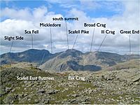
- Scafell Pike, 978 m (3,209 ft)
- Sca Fell, 964 m (3,163 ft)
- Great End, 910 m (2,986 ft)
- Bowfell, 902 m (2,959 ft)
- Esk Pike, 885 m (2,904 ft)
- Crinkle Crags, 859 m (2,818 ft)
- Lingmell, 807 m (2,648 ft)
- Coniston Old Man, 803 m (2,635 ft)
- Swirl How, 802 m (2,631 ft)
- Brim Fell, 796 m (2,612 ft)
- Great Carrs, 785 m (2,575 ft)
- Allen Crags, 785 m (2,575 ft)
- Glaramara, 783 m (2,569 ft)
- Dow Crag, 778 m (2,552 ft)
- Grey Friar, 773 m (2,536 ft)
- Wetherlam, 763 m (2,503 ft)
- Slight Side, 762 m (2,500 ft)
- Pike o' Blisco, 709 m (2,326 ft)
- Cold Pike, 701 m (2,300 ft)
- Harter Fell, 654 m (2,146 ft)
- Rossett Pike, 651 m (2,136 ft)
- Illgill Head, 609 m (1,998 ft)
- Seathwaite Fell, 601 m (1,972 ft)
- Rosthwaite Fell, 551 m (1,808 ft)
- Hard Knott, 549 m (1,801 ft)
- Whin Rigg, 535 m (1,755 ft)
- Green Crag, 489 m (1,604 ft)
- Lingmoor Fell, 469 m (1,539 ft)
- Black Fell, 323 m (1,060 ft)
- Holme Fell, 317 m (1,040 ft)
Book Five: The Northern Fells
The Northern Fells are a circular area north of Keswick. They are bordered by Bassenthwaite Lake to the west, the River Greta to the south, and the Caldew river to the east, which flows towards Carlisle. This is the smallest group of fells by number.

- Skiddaw, 931 m (3,054 ft)
- Blencathra, 868 m (2,848 ft)
- Skiddaw Little Man, 865 m (2,838 ft)
- Carl Side, 746 m (2,448 ft)
- Long Side, 734 m (2,408 ft)
- Lonscale Fell, 715 m (2,346 ft)
- Knott, 710 m (2,329 ft)
- Bowscale Fell, 702 m (2,303 ft)
- Great Calva, 690 m (2,264 ft)
- Ullock Pike, 690 m (2,264 ft)
- Bannerdale Crags, 683 m (2,241 ft)
- Bakestall, 673 m (2,208 ft)
- Carrock Fell, 663 m (2,175 ft)
- High Pike, 658 m (2,159 ft)
- Great Sca Fell, 651 m (2,136 ft)
- Mungrisdale Common, 633 m (2,077 ft)
- Brae Fell, 586 m (1,923 ft)
- Meal Fell, 550 m (1,804 ft)
- Great Cockup, 526 m (1,726 ft)
- Souther Fell, 522 m (1,713 ft)
- Dodd, 502 m (1,647 ft)
- Longlands Fell, 483 m (1,585 ft)
- Binsey, 447 m (1,467 ft)
- Latrigg, 367 m (1,204 ft)
Book Six: The North Western Fells
The North Western Fells are an oval-shaped area located below the Buttermere and Borrowdale valleys.

- Grasmoor, 852 m (2,795 ft)
- Eel Crag (Crag Hill), 839 m (2,753 ft)
- Grisedale Pike, 791 m (2,595 ft)
- Sail, 773 m (2,536 ft)
- Wandope, 772 m (2,533 ft)
- Hopegill Head, 770 m (2,526 ft)
- Dale Head, 753 m (2,470 ft)
- Robinson, 737 m (2,418 ft)
- Hindscarth, 727 m (2,385 ft)
- Whiteside, 707 m (2,320 ft)
- Scar Crags, 672 m (2,205 ft)
- Whiteless Pike, 660 m (2,165 ft)
- High Spy, 653 m (2,142 ft)
- Causey Pike, 637 m (2,090 ft)
- Maiden Moor, 575 m (1,886 ft)
- Ard Crags, 581 m (1,906 ft)
- Outerside, 568 m (1,864 ft)
- Knott Rigg, 556 m (1,824 ft)
- Lord's Seat, 552 m (1,811 ft)
- Whinlatter, 517 m (1,696 ft)
- Broom Fell, 511 m (1,677 ft)
- Barf, 468 m (1,535 ft)
- Barrow, 455 m (1,493 ft)
- Graystones, 452 m (1,483 ft)
- Catbells, 451 m (1,480 ft)
- Ling Fell, 373 m (1,224 ft)
- Sale Fell, 359 m (1,178 ft)
- Rannerdale Knotts, 355 m (1,165 ft)
- Castle Crag, 298 m (978 ft)
Book Seven: The Western Fells
The Western Fells are centered around Great Gable and form a triangle between the areas of Buttermere and Wasdale.

- Great Gable, 899 m (2,949 ft)
- Pillar, 892 m (2,927 ft)
- Scoat Fell, 841 m (2,759 ft)
- Red Pike (Wasdale), 826 m (2,709 ft)
- Steeple, 819 m (2,687 ft)
- High Stile, 807 m (2,648 ft)
- Kirk Fell, 802 m (2,631 ft)
- Green Gable, 801 m (2,628 ft)
- Haycock, 797 m (2,614 ft)
- Red Pike (Buttermere), 755 m (2,476 ft)
- High Crag, 744 m (2,441 ft)
- Brandreth, 715 m (2,345 ft)
- Caw Fell, 697 m (2,288 ft)
- Grey Knotts, 697 m (2,287 ft)
- Seatallan, 692 m (2,270 ft)
- Fleetwith Pike, 648 m (2,126 ft)
- Base Brown, 646 m (2,119 ft)
- Starling Dodd, 633 m (2,077 ft)
- Yewbarrow, 628 m (2,060 ft)
- Great Borne, 616 m (2,021 ft)
- Haystacks, 597 m (1,958 ft)
- Middle Fell, 582 m (1,909 ft)
- Blake Fell, 573 m (1,880 ft)
- Lank Rigg, 541 m (1,775 ft)
- Gavel Fell, 526 m (1,725 ft)
- Crag Fell, 523 m (1,715 ft)
- Mellbreak, 512 m (1,680 ft)
- Hen Comb, 509 m (1,670 ft)
- Grike, 488 m (1,601 ft)
- Burnbank Fell, 475 m (1,559 ft)
- Low Fell, 423 m (1,388 ft)
- Buckbarrow, 423 m (1,388 ft)
- Fellbarrow, 416 m (1,365 ft)
See also
