Catstye Cam facts for kids
Quick facts for kids Catstye Cam |
|
|---|---|
| Highest point | |
| Elevation | 890 m (2,920 ft) |
| Prominence | 63 m (207 ft) |
| Parent peak | Helvellyn |
| Listing | Hewitt, Nuttall, Wainwright |
| Geography | |
| Location | Cumbria, England |
| Parent range | Lake District, Eastern Fells |
| OS grid | NY348158 |
| Topo map | OS Landranger 90, Explorer OL5 |
Catstye Cam is a cool mountain, or 'fell', found in England's beautiful Lake District. It's like a smaller friend standing next to the much bigger mountain, Helvellyn, in the eastern part of the fells.
Contents
What's in a Name?
Have you ever wondered about mountain names? This mountain is usually called Catstye Cam. But some people, like the famous walker and writer Alfred Wainwright, preferred to spell it 'Catstycam'. He even mentioned another spelling, 'Catchedicam'! Even though maps from the Ordnance Survey (who make official maps) use 'Catstye Cam', many guidebooks follow Wainwright's spelling.
What Does Catstye Cam Look Like?
Catstye Cam is part of the Helvellyn range, a line of mountains stretching about 7 miles. These mountains stay above 2,000 feet (600 meters) for their whole length. Helvellyn, the main mountain, has smooth, grassy slopes on one side and rocky cliffs on the other.
Sharp Ridges and a Pyramid Shape
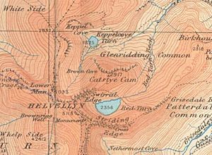
Helvellyn has two sharp, narrow ridges that stick out to the east. These are called arêtes. The one to the south is Striding Edge, which is very famous. The one to the north is Swirral Edge. From the top of Helvellyn, a rough slope leads down to Swirral Edge. This narrow ridge then curves down and back up for about half a mile, ending at Catstye Cam.
Catstye Cam has a classic mountain shape, like a pyramid. It really stands out, especially when the huge Helvellyn is hidden from view. Alfred Wainwright once said that if Catstye Cam stood alone, it would be one of the most beautiful peaks in the Lake District. He loved its simple, soaring lines and its small, pointed top. Even though it's connected to Helvellyn, Catstye Cam is still considered its own peak because of the dip in Swirral Edge.
East of the top, the ridge quickly drops down to a stream called Red Tarn Beck. There's also a third ridge to the northwest, which gives Catstye Cam its triangular shape. The northern side has some rocky cliffs, while the other two sides are steep but smooth.
Red Tarn and Brown Cove
South of Catstye Cam, tucked between Helvellyn's two ridges, is Red Tarn. This lake gets its name from the reddish color of the rocks around it, not the water itself. It's home to brown trout and schelly, which is a type of freshwater herring.
Red Tarn is about 80 feet deep today. In the mid-1800s, it was made deeper by building a dam with boulders. This was done to get more water for the Greenside Mine in Glenridding. You can still see the path where the water used to flow across the slope of Birkhouse Moor.
Another lake, Brown Cove Tarn, used to be north of Catstye Cam. Now, it's just a couple of small pools. Brown Cove Tarn was also created for the Greenside mine around 1860. The dam is still there, but water now leaks through its base. The area where the lake used to be is now a smooth, grassy patch. Water from Brown Cove and Red Tarn joins together at the bottom of the east ridge to form Glenridding Beck, which flows through the village and into Ullswater.
What Rocks is it Made Of?
The main type of rock that makes up Catstye Cam is called dacitic lapilli-tuff. This is a type of volcanic rock that was formed from ash and small rock fragments.
Reaching the Top
The very top of Catstye Cam is small and neat, with only a tiny pile of stones called a cairn. From the summit, you get amazing views! Even though Helvellyn looms large, it just adds to the dramatic scenery, showing off its eastern side in great detail. You can also see Striding Edge across Red Tarn, often with lines of people walking along it. In contrast, Catstye Cam is often quiet and peaceful.
How to Climb Catstye Cam
Most people climb Catstye Cam from the village of Glenridding. You can go up either its east or northwest ridges. Both paths are steep, but they are not difficult or dangerous.
Another good path climbs via Red Tarn to the middle of Swirral Edge. From there, you can take a short detour to reach the summit of Catstye Cam.
One of the best ways to explore this area is to do a circular walk. This amazing adventure takes you over Striding Edge, then up to Helvellyn, and finally across Swirral Edge to Catstye Cam. It's one of the most breathtaking walks in the country!
 | Isaac Myers |
 | D. Hamilton Jackson |
 | A. Philip Randolph |


