Eastern Fells facts for kids
The Eastern Fells are a group of hills in the Lake District in England. They are mostly a long ridge that runs from north to south, located between Ullswater lake and the main valley of the Lake District. The famous mountain Helvellyn is right in the middle of them.
Contents
What are the Lakeland Fells?
The Lake District is a special area in northwest England. It's a National Park because of its beautiful lakes and many hills. These hills are called "fells." Some fells are small, while others are among the tallest mountains in England. There are hundreds of fells, and people have tried to list them all and divide them into different areas. This helps people understand and describe them better.
Who divided the fells?
The most famous person to divide the fells was a writer named Alfred Wainwright. He wrote a series of books called Pictorial Guide to the Lakeland Fells. These books have been very popular since the first one came out in 1955. Wainwright split the fells into seven main areas. Each area is surrounded by valleys and low passes. Even though other writers have made their own maps, Wainwright's seven areas are still the most well-known way to divide the fells. The Eastern Fells are one of these areas, and they are covered in the first book of Wainwright's series.
Where are the Eastern Fells located?
The Eastern Fells are found between the A591 road (which goes from Keswick to Ambleside) and Ullswater lake.
What are the main groups of fells here?
The main part of the Eastern Fells is the Helvellyn range. This is a long line of mountains that runs from north to south. Most of the peaks in this range are over 2,000 feet (610 meters) high. South of the Helvellyn range, there's a dip called Grisedale Hause. Beyond this dip is another group of fells called the Fairfield group. There are also smaller hills and ridges, especially to the east of the main range. The Eastern Fells cover a large area, and their long, sweeping ridges are great for long walks.
What do the Eastern Fells look like?
Some of the Eastern Fells are found north of Ullswater. They seem to stand alone on a high, flat area between the lake and the lowlands to the northeast. Great Mell Fell and Little Mell Fell are round, smooth hills. They are often the first hills you see when coming from Penrith. Gowbarrow Fell is where you start to see more rocky areas.
The Helvellyn Range
The main Helvellyn range starts in the north at Clough Head. This fell is different from the others because its rocky cliffs are on the west side, and its smooth slopes are on the east. South from Clough Head are "The Dodds." These are three fells mostly covered in grass. Great Dodd and Stybarrow Dodd have long ridges that stretch to the east, surrounding the wet valley of Deepdale. Between them is Watson's Dodd, which is a ridge top but not very prominent.
The range then drops to a low point called Sticks Pass. This is a path for walkers and horses that connects the areas around Thirlmere and Ullswater. It's the only spot on the main ridge that is below 2,500 feet (762 meters).
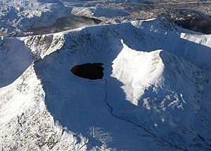
South of Sticks Pass, the western slopes of the fells remain smooth. However, the eastern sides become rockier as you go further south. Raise and White Side are followed by the highest fell in the east, Helvellyn. From Helvellyn's flat top, two famous rocky ridges stretch out to the east: Striding Edge and Swirral Edge. Striding Edge is one of the most famous ridge walks in the Lake District. The long valleys of Glenridding and Grisedale cut deep into the range from Ullswater. These valleys provide easy ways to reach this amazing walking area. The last peaks of the Helvellyn range are Nethermost Pike and Dollywaggon Pike. Both of these fells have broken, rocky faces when seen from Grisedale, but they look smooth from the west.
The Fairfield Group
The head of Grisedale valley rises towards Raise Beck on the western side, ending at the pass of Grisedale Hause. This low point (at 1,880 feet or 573 meters) separates the Helvellyn range from the more complex Fairfield group of fells. The Fairfield group starts with Seat Sandal. The main ridge then continues southeast over Fairfield, Hart Crag, and Dove Crag to a dip called Scandale Pass (which is a footpath).
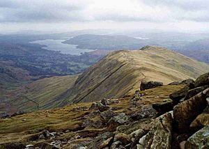
Like the Helvellyns, the Fairfield fells have rocky cliffs on their northeast sides and grassy slopes on the other sides. Long valleys cut into these fells from both directions. There's another Deepdale and Dovedale to the north, and Rydale and Scandale to the south. If Striding Edge is the most popular ridge walk, then the circular walk around Rydale, known as the Fairfield horseshoe, is the most popular circular ridge walk. Beyond Scandale Pass, standing a bit apart but still part of the Fairfield Group, is Red Screes. This is the last peak before the ground drops down to the road over Kirkstone Pass. The Far Eastern Fells rise on the other side of Kirkstone Pass.
How to access the Eastern Fells for walking?
Ambleside is a good starting point at the southwest corner of the range. There are many places to park cars there, or you can use public transport. In the east, where the mountains are more dramatic, Patterdale is a main hub. From Patterdale, you can use the long valleys of Grisedale and Glenridding to get deep into the fells. Further south, the entrances to Deepdale and Dovedale lead to the rocky scenery of the Fairfield Group. The Kirkstone Pass is also helpful because it starts at 1,500 feet (457 meters) high, giving you a head start for climbing Red Screes. There's even a pub there!
 | DeHart Hubbard |
 | Wilma Rudolph |
 | Jesse Owens |
 | Jackie Joyner-Kersee |
 | Major Taylor |


