
Great Mell Fell facts for kids
Quick facts for kids Great Mell Fell |
|
|---|---|

Great Mell Fell seen from Gowbarrow Fell
|
|
| Highest point | |
| Elevation | 537 m (1,762 ft) |
| Prominence | 198 m (650 ft) |
| Parent peak | Helvellyn |
| Listing | Marilyn (hill), Wainwright |
| Naming | |
| English translation | Large bare hill |
| Language of name | Brittonic (Cumbric), English |
| Geography | |

Great Mell Fell
Location in Lake District

Great Mell Fell
Location in Eden
|
|
| Location | Cumbria, England |
| Parent range | Lake District, Eastern Fells |
| OS grid | NY397254 |
| Topo map | OS Explorer OL5, Landranger 90 |
Great Mell Fell is a special hill in the Lake District in England. It stands alone, north of Ullswater, and is part of the Eastern Fells. This hill rises sharply from flat, marshy land to a height of 537 meters (about 1,762 feet).
From the top, you can see amazing views of many taller fells around it. The National Trust now owns and looks after Great Mell Fell. It's a peaceful place for both people and wildlife.
This hill used to have many trees. Even today, its lower slopes are covered in trees. You can also find scattered larch and pine trees higher up. The rocks here are unusual for the Lake District. They are a reddish type of rock called conglomerate. This rock has worn away over time, making the hill smooth and rounded, without any rocky cliffs.
Contents
About Great Mell Fell's Shape
Great Mell Fell is a hill that stands by itself. It rises suddenly from a wide, flat, and often wet area. The hill is 537 meters (1,762 feet) tall. It has smooth, rounded sides and no steep cliffs. You can only see rocks as large, scattered boulders. Some of these are on the north side. There's also a famous one called the Cloven Stone near a barn to the south.
The hill looks like a triangle or a wide arrow pointing west. This western side, often called the "nose" of the fell, is quite steep. The eastern slopes are gentler and wider. They have two small valleys. These valleys drain water into streams called Wham Sike and Routing Gill Beck.
Great Mell Fell sits on a natural line that divides where water flows. Water on the western side of the hill eventually flows into the River Derwent. Water on the eastern side flows into the River Eden. This means the hill helps decide which big river system the rainwater joins.
Plants and Animals
Great Mell Fell is a quiet home for wildlife. It's surrounded by farmland, making it a safe place for animals. The lower eastern slopes are covered with different kinds of trees. These include oak, rowan, birch, holly, and Scots pine.
Inside these woods, you might find badgers and roe deer living there. Green woodpeckers also build their nests among the trees. People say that the very last wild cat in the area was caught here in the 1800s.
Higher up the hill, you'll see an old group of Scots pine trees. They grow along the eastern ridge. Even higher, there are twisted larch trees. Some of these trees are almost flat from the strong winds. These trees show us what other fells might have looked like when they had more forests. An old book from the 1800s says that larch trees were planted all over the fell. However, the hill's name suggests it was treeless a long time ago.
The highest parts of the fell are covered with tough grass and some heather. You might even spot red grouse nesting there.
The Top of the Hill
The very top of Great Mell Fell has a low mound. Maps show this as a tumulus. This is probably a small burial mound from the Bronze Age. A small pile of stones, called a cairn, has been built on top of it. This cairn wasn't there in the 1950s. Back then, a dead tree trunk marked the highest point.
Because Great Mell Fell stands alone, its summit offers amazing views. You can see Blencathra and the Dodds mountains to the west. To the south, there's a great view of the Far Eastern and Eastern Fells. You can see as far as Red Screes and the Kirkstone Pass. Looking east, past Little Mell Fell, you can clearly see across the Eden Valley to the North Pennines.
How to Climb Great Mell Fell
Great Mell Fell is now owned and managed by the National Trust. This means the entire hill is open access land. You are free to walk and explore it.
You can start your climb from a few places. One way is near Brownrigg Farm. This is on a small road between Matterdale End and the A66 road. Another way is from just south of Troutbeck, on the A5091 road. You can follow a path along an old rifle range there.
There are paths just inside the fence that let you walk all the way around the hill. The western side of the fell is very steep, but it's a grassy climb to the top. A gentler way up is to follow a well-used path from the south-eastern corner. This path then goes along the east ridge to the summit.
History of the Hill
To the north-west of Great Mell Fell, there's an old rifle range that is no longer used. You can still see the building where they controlled the targets. This range was used starting in the late 1890s. The War Department (now the Ministry of Defence) used it during the war years and into the 1950s.
Because of the rifle range, people were not allowed to go onto the fell back then. There were red danger signs everywhere. A famous walker named Alfred Wainwright even drew one of these signs in his 1955 guide book. But he apparently ignored the warnings and explored the fell anyway! If you look carefully at the ground where the targets were, you might still find old bullet casings from that time.
The Rocks of Great Mell Fell

Both Great and Little Mell Fells are special because of the rocks they are made of. They are made of a rock called the Mell Fell Conglomerate. This is a sedimentary rock. It formed from sand and gravel that were laid down in ancient rivers and deserts. This rock is reddish and has no fossils in it. The pebbles inside this rock came from older mountains that wore away.
Scientists believe this reddish rock formed about 375 million years ago, during the late Devonian Period. Over millions of years, this rock has been worn down. This is why the Mell Fells have their smooth, rounded shapes. You won't find big cliffs here. However, you can see large boulders of this conglomerate rock in some places, especially on the north side. You can also spot it in the beds of the two streams on the hill.
Underneath this conglomerate rock, there's an even older rock. It's called the Birker Fell Andesite Formation. This rock formed from lava flows about 450 million years ago, during the Ordovician Period. You can see this older rock at the bottom of the fell in the south-east corner. There's a small, old quarry there where some of this andesite rock was taken out.
Rocks from the Devonian Period are sometimes called the Old Red Sandstone. It's important not to confuse them with the younger New Red Sandstone. That younger rock formed during the Permian Period and can be found nearby in Penrith.
What's in a Name?
The name Mell Fell comes from an older form, "Melfel," which was used in 1279. It likely comes from an old Brittonic word, męl. This word is similar to the Welsh word moel, which means a bare hill. The word "Fell" was added later.
"Fell" is a local word often used in the Lake District. It can mean a hill or a mountainous area. This word comes from Old Norse languages. Many place names in the Lake District use "Fell." Some of these names are very old, like Mell Fell, but many others are more recent.
People have called the two Mell Fells "Great" and "Little" since at least the 1400s. However, a map from 1823 by Greenwood called them West and East Mell Fell.
Images for kids
-

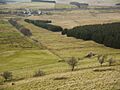
Great Mell Fell seen from the track alongside the old rifle-range to the north west
-
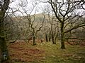
The wooded east slope of Great Mell Fell. Little Mell Fell is seen through the trees
-
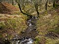
Routing Gill Beck on Great Mell Fell
-
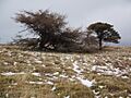
Larch and pine trees on the top of the east ridge of Great Mell Fell
-
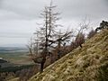
Larch tree on the steep west slope of Great Mell Fell
-
Disused rifle-range beneath Great Mell Fell
-
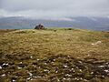
Summit cairn and remains of a Bronze Age tumulus on the summit of Great Mell Fell
-
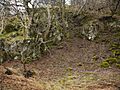
Small disused quarry in the andesite at the base of Great Mell Fell
-
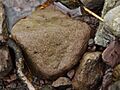
A boulder of Devonian conglomerate in the bed of Routing Gill Beck on Great Mell Fell


