
Little Mell Fell facts for kids
Quick facts for kids Little Mell Fell |
|
|---|---|

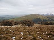
Little Mell Fell, seen from Great Meldrum (to the south), showing the western ridge and the summit dome
|
|
| Highest point | |
| Elevation | 505 m (1,657 ft) |
| Prominence | 226 m (741 ft) |
| Parent peak | Helvellyn |
| Listing | Marilyn, Wainwright |
| Naming | |
| English translation | Small bare hill |
| Language of name | Brittonic (Cumbric), English |
| Geography | |

Little Mell Fell
Location in Lake District
|
|
| Location | Cumbria, England |
| Parent range | Lake District, Eastern Fells |
| OS grid | NY423240 |
| Topo map | OSExplorer OL5, Landranger 90 |
Little Mell Fell is a small hill, or "fell," located in the beautiful Lake District in England. Its name means "bare hill," with "Fell" being a local word for a hill or mountain. It stands north of Ullswater lake, close to the village of Watermillock.
Little Mell Fell is quite similar to its neighbor, Great Mell Fell. Both fells are about the same size and look alike. They both appear somewhat isolated and have smooth, rounded shapes. What makes them truly special is their unique rock type, which is different from all other fells in the Lake District.
Contents
About Little Mell Fell
Little Mell Fell is a small area of high ground, shaped a bit like a "U." It covers about 2.6 square kilometers (1 square mile). Its highest point, or summit, is a rounded, grassy dome in the southeast. This summit reaches a height of 505 meters (1,657 feet).
Two short, grassy ridges extend from the summit: one goes north and the other west. The western ridge then turns north, creating a deep valley between the two ridges. This valley is where the upper parts of Thackthwaite Gill stream begin.
Connections to Other Hills
Little Mell Fell connects to other hills through a narrow pass called The Hause. This pass is south of the summit and links Little Mell Fell to Watermillock Fell. From there, a ridge of high ground runs southwest, alongside Ullswater lake, ending at Gowbarrow Fell. Along this ridge are other smaller tops like Watermillock Fell (424 meters) and Great Meldrum (437 meters).
Water Flow
The southeast part of Little Mell Fell drains directly into Ullswater lake. All other parts of the fell are drained by streams that flow into Dacre Beck. Dacre Beck then joins the River Eamont, which eventually flows into the Solway Firth. This means all the water from Little Mell Fell ends up in the Solway Firth.
Landscape and Wildlife
Most of Little Mell Fell is open and bare, with some small areas of trees. The lower slopes are divided into fields for farming. You might spot adders, a type of snake, on the fell, so it's good to be aware of your surroundings.
Reaching the Summit
The very top of Little Mell Fell is a rounded, grassy dome. You'll find an Ordnance Survey triangulation column there, which is a marker used for mapping.
From the summit, you get great views all around! Even though the top is gently curved, you can see far into the distance.
- To the east, you can see the Eden Valley and the Pennine Hills.
- To the north, you might spot the Southern Uplands of Scotland.
- To the west and south, you'll see many other fells of the Lake District, including the Northern, Eastern, and Far Eastern Fells.
- Closer by, you can see the lower part of Ullswater lake and the Martindale area.
How to Get There
Only the southern parts of Little Mell Fell are "Open Access" land, meaning you can walk freely there. You can start your walk from a few different spots:
- From the east, there's a small lane near the Cove camping park.
- From the south, you can access the fell from The Hause, where there's a minor road and some parking.
- From Lowthwaite Farm, a public path runs along the south side of the fell to The Hause.
- From the west, a track for tractors leads onto the fell, about 400 meters north of Lowthwaite Farm.
Once on the fell, there are three main paths that lead to the summit: one from the west ridge, one directly from The Hause in the south, and one from the east.
Unique Geology

Both Great and Little Mell Fells are very special because they are made of a unique rock called the Mell Fell Conglomerate. This rock is a sedimentary rock. It formed from sand and gravel that were deposited in ancient riverbeds and fan-shaped areas in a desert environment. Interestingly, this rock contains no fossils.
The stones within the conglomerate came from the wearing down of older rocks like the Borrowdale Volcanic Group and the Windermere Supergroup. This reddish rock is thought to be from the late Devonian Period, which was about 375 million years ago! The way this conglomerate has worn down over time is what gives the Mell Fells their smooth, rounded shapes.
Rocks from the Devonian Period are also known as the Old Red Sandstone. It's important not to confuse these with the younger New Red Sandstone rocks, which are found nearby in Penrith and the Eden Valley and formed during the Permian Period.
The Names of the Fells
The name Mell Fell comes from an old Brittonic (Cumbric) word, męl, which means "bare hill." The word "Fell" was added later.
Fell is a common local word in the Lake District. It comes from Old Norse words meaning "hill, mountain" or "mountainous country." Many places in the Lake District use "Fell" in their names.
The two Mell Fells have been called Great and Little since at least the 1400s. However, on an old map from 1823, they were called West and East Mell Fell instead.
The Hause is another name with Old Norse roots. It comes from the word hals, meaning "neck." This word is often used to describe a pass or low point between two valleys.
Image gallery
-
Little Mell Fell, seen from Great Mell Fell, showing the two ridges with the intervening valley
-
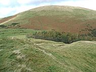
The grassy dome of Little Mell Fell, seen over The Hause from Watermillock Fell
-
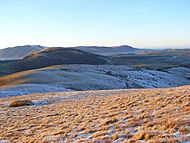
The rounded west ridge of Little Mell Fell, with Great Mell Fell beyond, and Blencathra and the Northern Fells in the distance
-
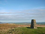
Triangulation pillar on the summit of Little Mell Fell


