
Gowbarrow Fell facts for kids
Quick facts for kids Gowbarrow Fell |
|
|---|---|

Gowbarrow Fell, seen from the summit of Hallin Fell, on the other side of Ullswater
|
|
| Highest point | |
| Elevation | 481 m (1,578 ft) |
| Prominence | 100 m (330 ft) |
| Parent peak | Little Mell Fell |
| Listing | Wainwright |
| Naming | |
| English translation | Windy hill |
| Language of name | Old Norse |
| Geography | |

Gowbarrow Fell
Location in Lake District
|
|
| Location | Cumbria, England |
| Parent range | Lake District, Eastern Fells |
| OS grid | NY408219 |
| Topo map | OSExplorer OL5, Landranger 90 |
Gowbarrow Fell (which means Windy hill) is a small fell in the beautiful Lake District in England. A fell is a type of hill or mountain, often found in northern England. This fell is part of the Eastern Fells and sits north of Ullswater, a famous lake. On one side, you'll find Aira Beck, a stream with a stunning waterfall called Aira Force. This waterfall is a very popular spot for visitors!
Hundreds of years ago, Gowbarrow Fell was part of a big hunting park called Gowbarrow Park. This park belonged to the lords of Greystoke Castle. In 1906, the National Trust, a charity that protects special places, bought the fell and 750 acres of the park.
Contents
Exploring Gowbarrow Fell
Gowbarrow Fell is shaped like a wedge of land, about 2 kilometers long and 1.5 kilometers wide. The highest parts are along a short ridge. The very top is called Airy Crag, which is 481 meters high. You can also find other smaller hills like Green Hill (437 meters) and Yew Crag.
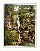
A stream called Aira Beck flows along the west side of Gowbarrow Fell. This stream comes down from the hills and flows into Ullswater lake. As it flows, it creates several waterfalls, including the famous Aira Force. Aira Force is one of the most photographed spots in the Lake District! The National Trust owns the falls and most of the fell. It's easy to visit from the A592 road, and there are paths and stone bridges that make it a great place for visitors.
To the south, Gowbarrow Fell meets Ullswater lake. The slopes facing the lake are covered in trees, making a lovely view. There are also rocky areas, like Yew Crag.

Reaching the Summit
The top of Gowbarrow Fell is a wide, flat area with small rocky bumps, heather, and some boggy (wet) spots.
The highest point is Airy Crag. Here, you'll find a special pillar built by the Ordnance Survey for mapping. It now has a plaque from the National Trust, showing they own the land. From the summit, you can see other fells like the two Mell Fells, Blencathra, and parts of the Helvellyn range. The summit is a bit far from Ullswater, so you can't see the whole lake. However, you can see the fells beyond it and the Patterdale valley.
For even better views of Ullswater, you can go to Green Hill, which is another high point on the fell.
Paths and Routes to the Top
Gowbarrow Park is owned by the National Trust, and you can walk freely across most of the land. Many paths lead up and around the fell, so you have lots of choices for your walk.
There's a main National Trust car park on the A592 road, which is popular for people visiting Aira Force. Other car parks are also available. If you start from the village of Dockray, a public footpath opposite the Royal Hotel offers the shortest way to the summit, which is about 1 mile. Another path starts from Ulcat Row to the north.
You can also approach from the east using a track from a place called The Hause. Or, you can take the Kirkstile footpath, which runs below Little and Great Meldrum. This path goes through a forest and then along the eastern and southern slopes of the fell, giving amazing views over Ullswater on its way to Aira Force.
It's also possible to climb up from the south, starting from a small parking spot on the A592 road and heading up Yew Crag.
The Rocks of Gowbarrow Fell
The rocks that make up Gowbarrow Fell were formed a very long time ago, about 460 million years ago, during a period called the Ordovician. There are two main types of rocks here: the Skiddaw Group and the Borrowdale Volcanic Group.
On the lower parts of the fell, you can find mudstones from the Skiddaw Group. These rocks were formed in deep seas when mud and sand slid down from the coast.
The higher parts of the fell are made of lava flows called the Birker Fell Andesite Formation. These rocks are part of the Borrowdale Volcanic Group. They were created when volcanoes erupted, sending out molten rock (lava) that flowed across the land. These volcanic rocks are a bit younger than the Skiddaw mudstones.
The oldest volcanic rocks on the fell are found on Little Meldrum. These are called the Little Meldrum Tuff Member. They were formed from volcanic ash and small pieces of lava that were thrown out during powerful volcanic eruptions.
What's in a Name?
The name Gowbarrow Fell has an interesting history. The word 'Fell' seems to have been added later. The area was known as Golbery around 1250 and Golebergh in 1294. This name probably comes from Old Norse words: gol, meaning 'a gust of wind or a breeze', and berg, meaning 'a rocky hill'. So, it means 'windy hill'.
The word "fell" itself is a local dialect word in the Lake District. It comes from Old Norse words meaning 'hill, mountain' or 'mountainous country'. You'll hear it a lot in place-names around the Lake District.
A Look Back in Time
Gowbarrow Fell is located within Gowbarrow Park, which was a medieval hunting ground. It was part of the lands belonging to Greystoke Manor.
The land was given to a man named Forne by King Henry I (who ruled from 1100 to 1135). Forne's son, Ivo, built the first stone tower at Greystoke Castle in 1129.
In 1418, the area of Matterdale was called a 'forest,' which meant it was a hunting ground. The Howard family took over the Greystoke estate in 1571. It seems the land remained a hunting area, as a visitor in the late 1600s noted it had more deer than trees! In 1794, it was recorded that the park covered about 2000 acres and had hundreds of deer. The tall stone wall that still surrounds the park today shows its old boundaries.
Later, in the 1800s, Charles Howard, the 11th Duke of Norfolk, built Lyulph's Tower. This was a hunting lodge near Aira Force, built on the site of an older tower. Its name might come from Sigulph, an ancestor who owned the land, and who the lake, Ullswater, might also be named after.
The famous poet William Wordsworth and his sister Dorothy Wordsworth walked through Gowbarrow Park on April 15, 1802. Dorothy was amazed by the daffodils growing near the water in Glencoyne Bay. She wrote in her journal, "I never saw daffodils so beautiful..." Her words inspired William to write his famous poem, I wandered lonely as a cloud (also known as Daffodils), two years later. William also wrote three poems about Aira Force.
During the 1800s, the Howard family improved Gowbarrow Park. They planted over half a million trees, built bridges, and created paths around Aira Force. In 1846, they planted a special collection of trees called an arboretum below the waterfall.
Then, in 1906, the National Trust bought 750 acres of the park. They did this to protect it from plans to build houses there.
Today, sheep graze on the fell instead of deer. But you can still see signs of its hunting past, like the strong stone wall around the fell and old shooting huts.
Image gallery
-
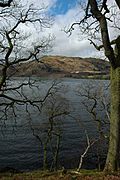
Gowbarrow Fell, seen from the opposite shore of Ullswater.
-
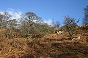
Part of the fellside on Gowbarrow Fell
-
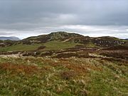
On top of Gowbarrow Fell, looking towards Airy Crag.
-

The summit of Gowbarrow Fell, with trig point.
-
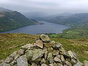
View of Ullswater from the cairn on Green Hill
-
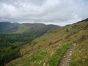
The footpath beneath Green Hill
-
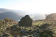
The remains of an old shooting lodge
-
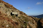
The memorial seat on Gowbarrow Fell. The inscription reads, "A thank-offering 1905"
-
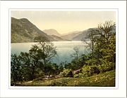
The view of Ullswater from Gowbarrow - a photochrom print
-
Aira Force - another photochrom print


