Raise (Lake District) facts for kids
Quick facts for kids Raise |
|
|---|---|
 |
|
| Highest point | |
| Elevation | 883 m (2,897 ft) |
| Prominence | c. 88 m |
| Parent peak | Helvellyn |
| Listing | Hewitt, Wainwright, Nuttall |
| Geography | |
| Location | Cumbria, England |
| Parent range | Lake District, Eastern Fells |
| OS grid | NY342174 |
| Topo map | OS Landranger 90 |
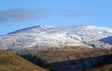
Raise is a mountain in the Lake District in England. It is part of the main Helvellyn range in the Eastern Fells. Raise sits between two large bodies of water, Thirlmere and Ullswater.
Contents
About Raise Mountain
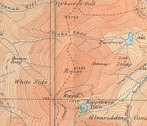
The Helvellyn mountain range stretches from north to south for about 11 kilometers (7 miles). It stays above 600 meters (2,000 feet) for its entire length. Raise is located near the middle of this long ridge. To its north is Stybarrow Dodd, and to its south is White Side.
Like many mountains in this area, Raise has smooth, grassy slopes on its western side. The eastern side has rougher ground, but the difference is not as big as on mountains further south.
It is unusual for a mountain this high, but Raise's slopes do not reach all the way down to the valley floor on either side. On the west, streams like Sticks Gill (West) and Brund Gill meet. They then flow down as Fisherplace Gill. In 1894, a special water channel was built to send most of this water into the Thirlmere reservoir.
On the eastern side, Raise also does not reach the shore of Ullswater. It has a short eastern ridge called Stang. This ridge goes down between Sticks Gill (East) and Glenridding Beck. These streams join up above the old Greenside Mine. This means that Sheffield Pike and Birkhouse Moor are the mountains that look over the village of Glenridding.
Sticks Pass: A High Mountain Path
North of Raise, there is a path called Sticks Pass. This path crosses the mountain ridge at a height of 745 meters (2,445 feet). It is the highest path in the Lake District that can be used by horses or walkers.
Today, it is mainly used by people hiking in the mountains. However, in the past, it was the only way to travel between the communities on opposite sides of the Helvellyn mountains. The name "Sticks Pass" likely comes from the guideposts, or "sticks," that were used to mark the route. The streams flowing from both sides of the pass are called Sticks Gill.
Mining History of Raise
South of Raise, the mountain ridge turns slightly west towards White Side. The eastern side of this ridge has a deep, bowl-shaped valley called Kepple Cove. The back wall of this valley is known as Red Screes.
Kepple Cove Tarn and the Dam Burst
Kepple Cove once had an artificial lake called a tarn. Today, this area is mostly marshy, except after heavy rain. The water from this tarn was used to power electric machines at the Greenside Mine. This system started in 1891 and was the first of its kind in the country.
However, on October 29, 1927, the Kepple Cove dam broke during a big storm. It left a gap about 24 meters (80 feet) wide in the dam. A huge wave of water rushed down the valley and through Glenridding village. It flooded buildings and caused a lot of damage. You can still see the broken dam today.
Other Mining Remains
Another tarn that helped Greenside Mine was built in Sticks Gill (East). It was called Top Dam. This dam was still there in the 1950s, but now it is a dry streambed.
You can find other signs of mining on the Stang ridge. One important sign is the stone smelter flue. This was a long pipe that carried smoke from the mine's smelting process. It ran for over 800 meters (half a mile) up the mountainside to a stone chimney at about 685 meters (2,250 feet) high. There are also remains of old water channels called leats. These channels were built to bring water to the mine.
Today, the Stang ridge also shows signs of a more modern activity. The Lake District's only permanent ski-tow is located on its northern slope. There are also some rocky areas on the eastern slopes of Raise, especially at Stang End above the Glenridding Beck.
Geology of Raise
The top of Raise mountain is made of a type of rock called andesite lava. This rock also has smaller pieces of volcanic rock called pyroclastic breccia to the southwest. There are also large areas covered with gravel and loose rock.
Summit of Raise
Raise is special among the northern Helvellyn mountains because its summit has exposed rock. It looks like a rocky island in a sea of grass. A little to the east of the very top, there is a rock formation called a tor. While it might not seem big elsewhere, it stands out in this grassy area.
A path follows the ridge, and there are many stone piles called cairns to the south. From the top, you can see a wide view of many major mountains. If you walk a short distance to the west, you can also see Thirlmere lake.
How to Climb Raise
The main ways to climb Raise are by using Sticks Pass. You can start this climb from either Legburthwaite or Glenridding.
If you want a more direct climb from the west, you can follow Fisherplace Gill. Then, you can walk up the grassy slopes. From the east, there is a path that goes directly up the Stang ridge. There is also an older path that zig-zags up from Glenridding Beck, next to Kepple Cove.
Lake District Ski Club
The Lake District Ski Club operates a special ski lift on Raise. It is a Poma-style lift, which means it pulls skiers up the mountain. They use it when there is enough snow for skiing or snowboarding.
The lift is over 300 meters long. The ski runs are in a natural snow bowl called Savages Gulley, where snow tends to pile up. The Lake District Ski Club has been active for a long time. By 2011, they had been operating for 75 years. Recently, they added new facilities, including a toilet building called the "Powder room" next to their engine hut.
 | Isaac Myers |
 | D. Hamilton Jackson |
 | A. Philip Randolph |


