
Sheffield Pike facts for kids
Quick facts for kids Sheffield Pike |
|
|---|---|

Sheffield Pike seen from Glencoyne
|
|
| Highest point | |
| Elevation | 675 m (2,215 ft) |
| Prominence | 91 m (299 ft) |
| Parent peak | Great Dodd |
| Listing | Hewitt, Nuttall, Wainwright |
| Geography | |

Sheffield Pike
Location in Lake District
|
|
| Location | Cumbria, England |
| Parent range | Lake District, Eastern Fells |
| OS grid | NY368182 |
| Topo map | OS Explorer OL5 |
Sheffield Pike is a mountain, also called a "fell," located in the beautiful Lake District in England. Its name might mean "the peak above the sheep fold." This mountain is a key part of the eastern side of the Helvellyn range and stands tall between two valleys, Glencoyne and Glenridding. From its slopes, you can look down onto the famous lake, Ullswater.
Contents
What Sheffield Pike Looks Like
Sheffield Pike is part of a long ridge that stretches east from another mountain called Stybarrow Dodd. This ridge goes over a grassy dip, then up to a spot called White Stones, and then to the top of Green Side. From Green Side, the ridge turns northeast towards Hart Side.
A part of Green Side slopes down about 200 meters (about 650 feet) to a lower area called Nick Head. This slope has been changed a bit by old mining activities. From Nick Head, the land rises 91 meters (about 300 feet) to the very top of Sheffield Pike, which is 675 meters (about 2,215 feet) high.
Sheffield Pike has two lower ridges that go down towards the east.
- One ridge, below a spot called Heron Pike, drops to a grassy dip and then rises to Glenridding Dodd. This is the last peak before you reach Ullswater.
- The other ridge goes through Glencoyne Wood and past Moss Crag, also leading towards Ullswater.
Between these two lower ridges is a quiet little valley called Mossdale.
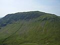
Sheffield Pike is shaped a bit like an oval and stands high above the Glencoyne and Glenridding valleys. Both sides of the mountain are quite steep. The south side, known as Glenridding Screes, is especially steep. The upper parts of the mountain on both sides have large areas of rocky cliffs, called crags.
Just east of the main summit is another smaller top named Heron Pike. It's 612 meters (about 2,008 feet) high and has a rocky tower with a couple of tiny mountain lakes, called tarns, nearby. It's interesting to note that there's another Heron Pike in the Lake District that's exactly the same height!
Water flows off Sheffield Pike in different directions.
- Water from the northern slopes drains into Glencoyne Beck.
- Water from the southern slopes flows into Glenridding Beck.
- Water from the eastern side goes into Mossdale Beck.
At the Top: The Summit
The top of Sheffield Pike isn't flat; it has gentle ups and downs. You might find some wet, marshy areas and small tarns between rocky spots. The ground is covered with rough grass and heather plants.
The highest point is marked by a wide pile of stones, called a cairn, on top of a rocky outcrop. You'll also see two old iron posts, one on Heron Pike and another above Nick Head. These posts have "H 1912" on one side and "M 1912" on the other. They mark the old boundary between two large land estates: the Howard estate and the Marshall estate. The summit cairn also has an old stone boundary marker with the letters "H" and "M," plus a mysterious "E.R." and the date 1830.
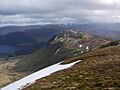
While the summit gives a good view of Glencoyne, you can get even better views of Ullswater from other spots. For example, the cairn above Black Crag or the top of Heron Pike offer great lake views. If you follow a well-used sheep path along the crags on the south side of the mountain, you'll get the best views of upper Glenridding, with Catstye Cam and Helvellyn in the background.
How to Climb Sheffield Pike
Most of Sheffield Pike is "Open Access" land, which means you are allowed to walk freely on it, away from roads and old mine sites.
You can start your climb from the village of Glenridding or from Glencoyne, following the track behind a place called Seldom Seen. You can use one of two main routes to get up the mountain.
- From Glenridding, a path called The Rake leads to the eastern dip (col).
- Another path from Glenridding goes past the old Greenside Mine and leads to Nick Head, the western dip. When the famous walker Alfred Wainwright wrote about this area in 1955, the mine was still working and made the area look very industrial. Today, the mine is closed, but you can still see the piles of waste rock, called "spoil heaps," and some of the old mine buildings. Part of the mine buildings have even been turned into a Youth Hostel!
Sheffield Pike can also be part of longer walks. You could climb Glenridding Dodd first, then continue to Hart Side for a loop around Glencoyne. Or, for a much longer adventure, you could go from Sheffield Pike to Stybarrow Dodd and then to Helvellyn, making a big horseshoe-shaped walk around Glenridding.
The Rocks of Sheffield Pike
Almost all the rocks that make up Sheffield Pike are part of something called the Borrowdale Volcanic Group. These rocks were formed about 450 million years ago, during a time known as the Ordovician Period, when there was a lot of volcanic activity on the edge of an ancient continent.
Most of the rocks on Sheffield Pike belong to the Birker Fell Andesite Formation. These are thick layers of a type of rock called andesite. They were created by many eruptions of flowing lava from volcanoes that had gentle slopes.
Sometimes, between these lava flows, you can find layers of volcaniclastic sandstone. This is a type of rock made from bits of older volcanic rocks that have been worn down and deposited. There's a small amount of this near the top of Sheffield Pike.
There are also two smaller areas where hot, melted rock pushed its way into existing rocks and then cooled.
- One is a basalt dyke (a wall-like rock formation) of a similar age to the volcanic rocks, which crosses Nick Head.
- The other is a microgranite dyke that's much younger, from the Devonian age. It runs near the top of the crags on the south side of the mountain. This dyke was likely formed when a huge mass of granite, called a batholith, was pushing up from deep underground beneath the Lake District.
The granite batholith also helped create mineral veins in some parts of the Lake District. The richest known lead vein was found crossing the southeast shoulder of Green Side, running north to south.
Greenside Mine History
Mining for lead at the Greenside Mine started in the 1700s. Miners would dig tunnels, called "levels," into the side of Green Side. In 1853, a new main tunnel was started from the current mine entrance at Lucy’s Tongue, below Nick Head. This tunnel was dug for 16 years, going north and west, to reach the rich Greenside lead vein. This allowed miners to dig even deeper for the lead. Over its entire working life, the mine produced a huge amount of ore, about 2,400,000 tons! The mine finally closed in 1962.
Today, you can still see a lot of evidence of the mining, especially the large spoil heaps (piles of waste rock) on the lower slopes of Sheffield Pike. As mentioned, part of the old mine buildings have been turned into a Youth Hostel.
What's in a Name?
Sheffield Pike
The name Sheffield Pike is a bit of a mystery. The first time it was officially used was by the Ordnance Survey (a mapping agency) in 1859.
- One idea is that it's connected to the Howard family, who owned land in the area and also had estates in Sheffield. However, there's no clear proof for this.
- Another idea is that the original name might have been something like "Sheepfold Pike," and over time, the pronunciation changed to "Sheffield Pike." Again, there's no direct proof. It's possible both ideas could be true!
Heron Pike
The name Heron Pike is also a bit puzzling. In old guidebooks from the 1800s, it was sometimes called "Herring Pike." Both "Heron" and "Herring" seem unlikely for a mountain. It's most likely that the name came from an old English word, erne, which means 'eagle', combined with 'pike' (meaning peak).
Images for kids
-
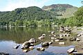
Glenridding Dodd and Sheffield Pike seen from the shores of Ullswater
-
Sheffield Pike seen from Glencoyne
-
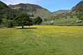
The east ridge of Stybarrow Dodd above Glenridding, seen from Angletarn Pikes
-
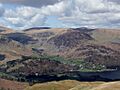
Glenridding Dodd, Heron Pike and Sheffield Pike, seen from Place Fell
-
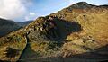
The south-east shoulder of Sheffield Pike with Heron Pike
-
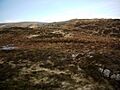
The summit plateau on Sheffield Pike
-
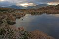
A tarn on Sheffield Pike
-
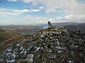
The summit cairn on Sheffield Pike, with stone boundary marker, and Ullswater beyond
-
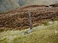
Iron boundary marker on Sheffield Pike
-
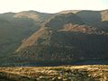
Sheffield Pike, seen on the descent from Green Side
-
Sheffield Pike, seen from Hart Side


