
Glenridding Dodd facts for kids
Quick facts for kids Glenridding Dodd |
|
|---|---|

Glenridding Dodd, seen from the other side of Ullswater, showing Stybarrow Crag by the shore
|
|
| Highest point | |
| Elevation | 442 m (1,450 ft) |
| Prominence | 45 m (148 ft) |
| Parent peak | Sheffield Pike |
| Listing | Wainwright |
| Geography | |

Glenridding Dodd
Location in Lake District
|
|
| Location | Cumbria, England |
| Parent range | Lake District, Eastern Fells |
| OS grid | NY381175 |
| Topo map | OS Explorer OL5 |
Glenridding Dodd is a small but mighty hill in the beautiful Lake District in England. Its name means 'the rounded hill above Glenridding'. This hill is part of the Eastern Fells and sits right above the village of Glenridding. It's also on the western shore of Ullswater, one of the Lake District's biggest lakes.
Even though Glenridding Dodd isn't super tall, it offers amazing views. From its top, you can see the sparkling waters of Ullswater. You can also spot many other fells (that's what they call mountains in the Lake District) around the valleys near Patterdale. It's a fantastic spot for a short hike and some stunning scenery!
Contents
What is Glenridding Dodd Like?
Glenridding Dodd is the last part of a ridge that comes down from a bigger mountain called Stybarrow Dodd. It looks like a short ridge that runs from east to west. This ridge sits right above the village of Glenridding.
On its eastern side, the hill drops very steeply. It ends in a rocky cliff called Stybarrow Crag, right by the A592 road and the shore of Ullswater. To the west, there's a dip in the land that separates it from Sheffield Pike.
To the north, you'll find Mossdale Beck, which is a small stream. To the south, it's bordered by Glenridding village and Glenridding Beck. The lower parts of the hill are covered in trees. You'll see leafy trees like the Stybarrow Oaks on the south and east sides. On the north side, there are larch trees that almost reach the top.
Glenridding Dodd is quite small, only about 1 kilometer long. Its highest point is 442 meters (about 1,450 feet) above sea level. Even so, it gives you incredible views over Ullswater, which is nearly 300 meters below.
Reaching the Top
The very top of Glenridding Dodd is a short, flat area. It has patches of heather, some rocky bumps, and a few marshy (wet) spots. The highest point is at the western end and has a small pile of stones called a cairn.
However, for the best views, you should head to the eastern end of the ridge. From here, you can see almost all of Ullswater and the village of Glenridding below. It's a truly "delightful" view for a hill that isn't very high.
Looking out, you'll see the interesting shape of Birkhouse Moor and Keldas, which is a smaller hill closer to the lake. Further south, you can see many other fells gathered around the valleys above Patterdale.
Near the summit, there's a special stone marker. It has the letter 'M' on one side and 'H' on the other. This stone used to mark the boundary between the lands of two important families: the Marshall family of Patterdale and the Howard family of Greystoke.
How to Hike Glenridding Dodd
Much of the land around Glenridding village is privately owned. But once you get above a certain wall, the fell becomes "Open Access" land. This means you are free to explore it!
You can start your hike from Glenridding village. There's a big car park there. One popular path is called The Rake. Another way to start is from a parking spot on the A592 road, just north of Stybarrow Crag. This spot is right by Mossdale Beck.
Both of these paths meet at a wall that crosses the dip in the land to the west of the summit. From there, it's just a short climb to reach the top of Glenridding Dodd.
The famous fell-walker Alfred Wainwright once wrote about Glenridding Dodd. He mentioned that it used to be a very popular climb because of its great views. However, in his time, some of the older paths had become overgrown and less used.
The Rocks of Glenridding Dodd
The rocks that make up Glenridding Dodd are very old! They are part of something called the Borrowdale Volcanic Group. These rocks were formed about 450 million years ago. This was during a time called the Ordovician Period, when there was a lot of volcanic activity on the edge of an ancient continent.
Most of the rocks on the hill are from the Birker Fell Andesite Formation. This means they were mostly created by eruptions of a type of lava called andesitic lava. This lava was quite runny and came from volcanoes that weren't very steep. These rocks are part of a thick layer of lava found all around the western and northern parts of the Lake District.
Mixed in with these andesitic lavas were smaller amounts of dacitic lava. This type of lava is thicker and stickier because it has more silica. You can find these dacitic rocks on the lower parts of the southern and eastern slopes of the hill.
What Do the Names Mean?
Many of the names in the Lake District have interesting meanings from old languages.
- Glenridding Dodd has been known by this name since at least 1823. 'Glenridding' probably means 'the valley full of bracken'. 'Glen' comes from an old word for 'valley', and 'ridding' is like the Welsh word for 'fern' or 'bracken'. 'Dodd' is a local word used for rounded hilltops, especially those that are not super tall or are smaller parts of bigger hills.
- Mossdale means 'boggy valley'. 'Moss' comes from old words meaning 'bog', and 'dale' comes from an Old Norse word for 'valley'.
- The Rake means 'the track'. This word is used in other parts of the Lake District for a narrow path on a hill.
- Bleas Crag might mean 'the dark crag'. 'Blea' comes from an Old Norse word meaning 'dark', and 'crag' means a steep, rugged rock or cliff.
Image gallery
-
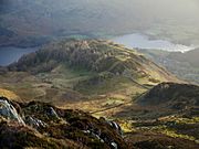
Looking down onto Glenridding Dodd from the summit of Heron Pike
-
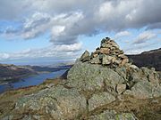
Cairn on the summit of Glenridding Dodd
-
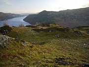
Rocky knolls on the summit ridge of Glenridding Dodd
-
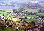
Looking down onto Glenridding village from the summit


