
Stybarrow Dodd facts for kids
Quick facts for kids Stybarrow Dodd |
|
|---|---|

Stybarrow Dodd and the ravine of
Stanah Gill on its western slopes |
|
| Highest point | |
| Elevation | 843 m (2,766 ft) |
| Prominence | 68 m (223 ft) |
| Parent peak | Great Dodd |
| Listing | Hewitt, Wainwright |
| Geography | |

Stybarrow Dodd
Location in Lake District
|
|
| Location | Cumbria, England |
| Parent range | Lake District, Eastern Fells |
| OS grid | NY343189 |
| Topo map | OS Landranger 90, Explorer OL5 |
Stybarrow Dodd is a mountain in the English Lake District. Its name means "the hill of the steep path." It stands just north of Sticks Pass. This mountain is part of the main ridge of the Helvellyn range in the Eastern Fells. This area is located between two lakes, Thirlmere and Ullswater.
The top of Stybarrow Dodd is smooth, round, and covered in grass. It looks similar to its two northern neighbours, Watson's Dodd and Great Dodd. These three fells are sometimes called ‘The Three Dodds’. All three are made of the same type of volcanic rock.
Contents
Exploring Stybarrow Dodd
The top of Stybarrow Dodd is part of the main Helvellyn ridge. This ridge stretches for about 11 kilometers (7 miles) and stays high, never dropping below 600 meters (1,968 feet). Stybarrow Dodd makes up about 1 kilometer (0.6 miles) of this ridge.
The mountain rises to 843 meters (2,766 feet) high. From its smooth, grassy top, four different ridges spread out like arms.
Western Slopes
To the west, a grassy ridge goes down for about 2 kilometers (1.2 miles). It leads into the valley of How Beck and towards the A591 road. This ridge is clearly defined by the valleys of Stanah Gill to its north and Sticks Gill (West) to its south.
A path for walkers and horses, called a bridleway, goes up this western ridge to Sticks Pass. The streams here, Stanah Gill and Sticks Gill, now send their water into Thirlmere Reservoir.
Eastern Slopes
The eastern side of Stybarrow Dodd is more spread out. Its eastern ridge splits into three parts. This means the base of the mountain stretches along Ullswater lake. This side has many streams, like Aira Beck, Sticks Gill (East), and Glencoyne Beck. All these streams flow directly into Ullswater.
Northern Spurs
There are also two shorter ridges to the north of the main top. One goes northwest to a lower point that connects to Watson's Dodd and Great Dodd. Another, longer ridge called Middle Tongue, goes northeast for 1.5 kilometers (0.9 miles) into Deepdale valley.
Sticks Pass: A Historic Route
Sticks Pass is located south of Stybarrow Dodd. It crosses the Helvellyn ridge at about 745 meters (2,444 feet) high. This makes it the highest pass in the Lake District that has a bridleway.
In the past, Sticks Pass was an important route. It connected communities on both sides of the Helvellyn range. Today, it is mostly used by fellwalkers. The streams on both sides of the pass are called Sticks Gill on maps.
The path to the pass starts from Stanah in the west. It climbs over the west ridge of Stybarrow Dodd. In 1928, the path was marked by sticks, which is how the pass supposedly got its name. However, by the 1950s, these sticks were gone.
Reaching the Summit

Stybarrow Dodd has a short, grassy top with two small piles of stones, called cairns. The main path leads to the south-western cairn. However, the very highest point is about 300 meters (984 feet) to the northeast. This spot is quieter and has a small cairn with an upright piece of slate.
The south-western top is only three meters (10 feet) lower. It is right on the main path and also has a small cairn. In the 1950s, this was the point marked on maps as the highest.
From the north-east top, you can see a wide view of the Lakeland fells. The south-west top also offers a great view, but without the flat foreground.
Climbing Stybarrow Dodd
Most of the mountain, above the farm walls, is Open Access land. This means you can walk freely there. Much of the eastern side is owned by the National Trust.
You can start climbing Stybarrow Dodd from different places:
- From the west, you can start at Stanah and follow the bridleway to Sticks Pass.
- From the east, you can start from Glenridding. You can take the Sticks Pass bridleway or go via the Sheffield Pike and Green Side ridge.
- From the northeast, you can start from Dockray or High Row. You can follow the Hart Side ridge or go through the Deepdale valley.
Many people enjoy a popular walk called ‘The Dodds’. This walk combines the three tops of Stybarrow Dodd, Watson’s Dodd, and Great Dodd. It often involves walking in a circle around Deepdale from High Row or Dockray.
How Stybarrow Dodd Was Formed

The rocks of Stybarrow Dodd are all part of the Borrowdale Volcanic Group. These rocks formed about 450 million years ago during the Ordovician Period. This was a time when there was a lot of volcanic activity.
Most of the rocks on Stybarrow Dodd are from the Birker Fell Andesite Formation. These are some of the oldest volcanic rocks in the Lake District. They formed from many eruptions of runny lava from volcanoes.
Later, the type of lava changed and the eruptions became more explosive. A huge caldera volcano formed where Scafell and the Langdale Pikes are today. A caldera is a large basin-shaped hole left after a volcano collapses.
After this, another caldera volcano formed. The rocks on top of Stybarrow Dodd are from the Lincomb Tarns Tuff Formation. This formation is made of a rock called ignimbrite. Ignimbrite forms from very hot gas and rock flowing out of a volcano. It seems the whole Lake District was covered by a thick layer of this rock.
On Stybarrow Dodd, this formation is called the Thirlmere Tuff Member. It covers the top of the mountain with a thick layer of rock. This rock looks white or pink when exposed. However, it is usually covered by the smooth, grassy turf that makes Stybarrow Dodd, Great Dodd, and Watson’s Dodd look so similar.
What's in a Name?
The name Stybarrow Dodd has changed over time. It was recorded as Stibarro in 1589 and Stybarrow as late as 1800. The word Dodd was added later.
The name probably means 'hill of the steep path'. This refers to the path over Sticks Pass on its side.
- Sty(e) is an old word for ‘a steep path’.
- Barrow comes from an Old English or Old Norse word meaning ‘a hill’ or ‘a mountain’.
The word Dod or Dodd is a local dialect word. It is common in hill names in the Lake District. It describes bare, rounded hilltops.
Images for kids
-
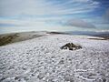
Looking along the summit ridge, from the cairn on the south top. The north top is on the skyline
-
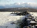
Broken-down wall on the summit of Stybarrow Dodd
-
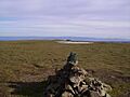
Cairn on the north top of Stybarrow Dodd incorporating the slate marker. Beyond is the intermittent pool, and the remains of the wall
-
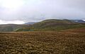
Stybarrow Dodd, seen from Great Dodd, with Green Side to the left


