
Hart Side facts for kids
Quick facts for kids Hart Side |
|
|---|---|

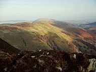
Hart Side seen from Great Dodd
|
|
| Highest point | |
| Elevation | 2,480 ft (760 m) |
| Prominence | 75 ft (23 m) |
| Parent peak | Green Side |
| Listing | Nuttall, Wainwright |
| Geography | |

Hart Side
Location in Lake District
|
|
| Location | Cumbria, England |
| Parent range | Lake District, Eastern Fells |
| OS grid | NY359198 |
| Topo map | OS Explorer OL5 |
Hart Side is a mountain in the Lake District in England. Its name means "the hillside where male deer (harts) are often found."
This mountain is part of the Eastern Fells and is located west of Ullswater. It's a smaller peak connected to a larger mountain called Stybarrow Dodd. Hart Side stands at 2,480 feet (756 meters) tall.
Some guidebooks treat Hart Side as its own special mountain. They even have separate chapters about it! Other writers focus more on how to hike to all the different peaks in the Lake District.
Hart Side and Green Side are two parts of a ridge made of a rock called andesite. This rock formed from ancient volcanoes. A very successful lead mine in the Lake District used to be on the Green Side part of this ridge. It closed in 1962.
Contents
What does Hart Side look like?
The east ridge of Stybarrow Dodd drops down to a wide, flat area called a col. From there, the ground rises again to form the Hart Side and Green Side ridge. This ridge is smooth, rounded, and covered in grass. It stretches for about 1.5 miles (2.4 km) to the north-east.
The highest point on this ridge is Green Side, which is 2,608 feet (795 meters) tall. After Green Side, the ridge dips down before rising again to the summit of Hart Side.
The ridge then turns sharply and rises to another rounded, grassy area about 2,428 feet (740 meters) high. A part of this area is called Birkett Fell. It was named in 1963.
The ridge continues east as Watermillock Common.
To the north and west of Hart Side and Green Side, grassy slopes lead down into a valley called Deepdale. There's a rocky area just below Hart Side's summit called Hart Crag. Water from these slopes flows into Aira Beck and then into Ullswater.
The south side of Hart Side and the east side of Green Side have much steeper cliffs. This area is called Glencoyne Head. During the last ice age, a glacier formed here, creating these steep cliffs. Water from these slopes drains into Glencoyne and then into Ullswater.
The south side of Green Side also drops steeply into Stick's Gill (East) valley. This water also flows into Ullswater.
The Summit of Hart Side
The top of Hart Side is mostly grassy, but you can see some rocks poking through. Hikers have built a few small piles of stones, called cairns, on the summit.
One interesting feature is a long trench dug into the ground a few yards south of the summit. This trench was likely dug by people looking for more lead, hoping to find an extension of the mine that was under Green Side. There's also a shallow hollow nearby, which might have been a shelter.
The view from the summit is a bit limited because of the higher mountains to the west. You can catch glimpses of Catstye Cam and Helvellyn. You also get a good view of Great Dodd and Stybarrow Dodd across Deepdale. On a clear day, you might even see a tiny bit of Scafell Pike, England's highest mountain.
For an even better view of Ullswater and the eastern areas, you can go to Birkett Fell. There's a special cairn there. It was built from stones carried up by students from the Outward Bound School. This cairn has a stone plaque with the name of the fell. It honors Lord Birkett of Ulverston. He played a big part in stopping Ullswater from being turned into a reservoir.
How to Climb Hart Side
Most of the land around Hart Side, Green Side, and Watermillock Common is now "Open Access" land. This means you can walk freely across it.
There are several ways to climb Hart Side from the north-east. You can start from a car park at High Row and go via Dowthwaitehead and Birkett Fell. From Dockray, or the car parks near Aira Force, you can climb via Watermillock Common and Birkett Fell.
From the south, you can climb up the south-east side of Green Side, above the old Greenside lead mine. You can also take a steep, pathless route from the old Miners’ Balcony Path.
Hart Side can also be part of a longer hike around Deepdale, which includes the three Dodds mountains.
The Rocks of Hart Side

The rocks that make up Hart Side and Green Side are part of the Borrowdale Volcanic Group. These rocks formed about 450 million years ago during a time of intense volcanic activity.
Most of the rocks on the mountain are from the Birker Fell Andesite Formation. These formed mainly from eruptions of runny lava from volcanoes.
Later, some dykes (rock formations that cut through other rocks) were pushed into the andesite. These are found in the cliffs of Glencoyne Head.
The Lake District also has special mineral veins. The richest known lead vein was found crossing the south-east side of Green Side. This was the Greenside Lead Vein. It ran north-south and was very wide in some places.
This vein contained galena, which is a lead ore. The ore from Greenside also had silver in it. Higher parts of the vein also contained baryte, a mineral that wasn't valuable at the time.
The Greenside Mine operated from the 1700s until 1962, when all the lead was gone. The main entrance was in Glenridding. There was also an emergency exit in the cliffs at Glencoyne.
Underneath the volcanic rocks are older mudstones. Miners found these rocks in the deepest parts of the Greenside Mine. The lead vein stopped when it reached these mudstones.
Watermillock Common
| Watermillock Common | |
|---|---|
| Common Fell | |

Watermillock Common seen from Birkett Fell
|
|
| Highest point | |
| Elevation | 1,814 ft (553 m) |
| Prominence | 49 ft (15 m) |
| Parent peak | Hart Side |
| Geography | |
| OS grid | NY 379197 |
Watermillock Common is a high ridge of land that rises 1,312 feet (400 meters) above Ullswater. It's the end part of one of the long eastern ridges of Stybarrow Dodd. It lies lower than the Hart Side part of the ridge.
This part of the ridge stretches about 1.75 miles (2.8 km) to the north-east from the foot of Hart Side. Water from its northern and eastern sides drains into Aira Beck. Its south-eastern slopes drain directly into Ullswater. Aira Beck has carved a steep gorge between Watermillock Common and Gowbarrow Fell.
The highest point on Watermillock Common is Swineside Knott, at 1,814 feet (553 meters). It's a rounded, grassy hill with some rocks. Swineside Knott offers a fantastic view of Ullswater, from one end of the lake to the other.
Common Fell is only 3 feet (1 meter) lower than Swineside Knott, at 1,811 feet (552 meters). It feels more like the main summit because it's in the middle of the ridge. It has several rounded grassy mounds. There's a small cairn on the highest one. You can also see a remarkable glacial erratic boulder perched on another mound. Common Fell gives good views to the north and east.
Two lower hills at the east end of the ridge are Round How (1,270 feet / 387 meters) and Bracken How (1,214 feet / 370 meters). Both are rounded and grassy with some rocks and small cairns.
Most of Watermillock Common is "Open Access" land. Paths across the common start from the village of Dockray and from two car parks on the A5091 road.
The oldest rocks on Watermillock Common are mudstones from the Skiddaw Group. These were formed in deep seas about 470 million years ago. Most of the ridge is made of andesite rocks from volcanoes. You can also find areas of hyaloclastite, a rock made of shattered fragments formed when lava cooled quickly in water.
How these places got their names
Hart Side gets its name from the old English words for "hillside frequented by harts." A hart is a fully grown male red deer, at least five years old. The name was first written on maps in 1867. Older guidebooks sometimes called it Glen Coin Fell.
Green Side is named simply because it's a "green hillside."
Watermillock Common was the open grazing land for the village of Watermillock. It was outside the enclosed Gowbarrow deer park.
Birkett Fell was once called Nameless Fell on maps. It was named in 1963 to remember Lord Birkett of Ulverston. In 1962, just before he passed away, Lord Birkett gave a famous speech. He argued against a plan that would have turned Ullswater into a reservoir for Manchester. Because of his speech, the plan was stopped, which made many Lake District lovers very happy.
Images for kids
-
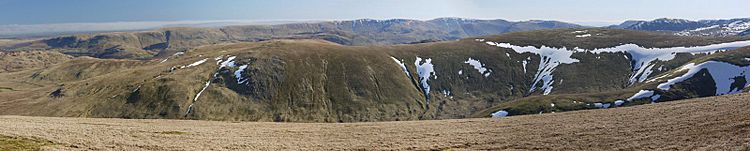
The whole Green Side and Hart Side ridge, with Watermillock Common to the left, seen from Great Dodd

-
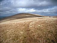
Looking along the ridge from Green Side towards Hart Side
-
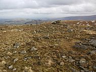
The summit of Hart Side
-
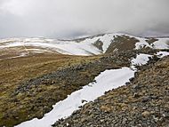
The prospecting trench on the summit of Hart Side, partly filled with snow, with Green Side and Stybarrow Dodd in the distance
-
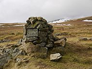
The cairn on Birkett Fell with Stybarrow Dodd beyond
-
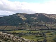
Watermillock Common seen from Heron Pike
-
Watermillock Common seen from the north, across the valley of Aira Beck
-
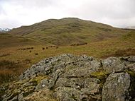
Common Fell on Watermillock Common, seen from Bracken How
-
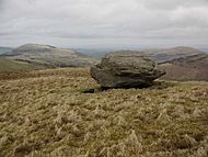
Glacial erratic boulder on Common Fell
-
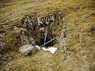
Emergency exit from the Greenside Mine in Glencoyne


