
White Side facts for kids
Quick facts for kids White Side |
|
|---|---|

White Side is the green hill in the foreground.
By Ann Bowker. |
|
| Highest point | |
| Elevation | 863 m (2,831 ft) |
| Prominence | 42 m (138 ft) |
| Parent peak | Raise |
| Listing | Hewitt, Wainwright, Nuttall |
| Geography | |

White Side
Location in Lake District
|
|
| Location | Cumbria, England |
| Parent range | Lake District, Eastern Fells |
| OS grid | NY337166 |
| Topo map | OS Landranger 90, Explorer OL5 |
White Side is a fell (a type of mountain or hill) in the beautiful Lake District in England. It sits between the Thirlmere lake to the west and the Glenridding valley to the east. This means White Side is part of the Helvellyn range in the Eastern Fells. To its north is Raise and to its south is Helvellyn, both of which are taller.
Contents
What's in a Name?
The name White Side actually refers to the western slope of this hill, not the whole summit itself. But for simplicity, people often call the entire fell "White Side." A famous guidebook writer, Alfred Wainwright, treated White Side as its own separate fell. He thought the name might come from the white quartz rocks found on its western side.
Exploring White Side's Shape
The two sides of White Side look very different.
The Steep Eastern Side
The eastern side of White Side is quite dramatic. It has many steep crags (rocky cliffs) and scree (loose rocks) that drop sharply into two bowl-shaped hollows called Keppel Cove and Brown Cove.
Keppel Cove's Story
Keppel Cove is a large, deep hollow on the eastern side, just north of the top. It used to have an artificial tarn (a small mountain lake). Today, the lake bed is mostly marshy, except when it rains a lot.
The water from this tarn was once used to create hydroelectric power. This power helped run electric machines at the Greenside Mine. This system started in 1891 and was the first of its kind in the country!
However, on a stormy night in 1927, the Keppel Cove dam broke. This left a huge gap in the earthworks. A big wave of water rushed down the valley and through Glenridding village. It flooded buildings and caused a lot of damage. You can still see the broken dam today.
Brown Cove's Past
South of Keppel Cove is Brown Cove. This area also had an artificial tarn, created around 1860 for the Greenside mine. Now, it's just a few small pools. The old stone dam is still there, but water leaks through its base.
Water from both Brown and Keppel Coves joins with water from Helvellyn's Red Tarn. Together, they form Glenridding Beck, which flows through the village and into Ullswater lake.
The Gentle Western Side
In contrast, the western side of White Side slopes gently down towards Thirlmere. The upper parts are mostly covered in grass. Lower down, you can find some rocky areas, like Brown Crag.
The streams on the western slopes, Helvellyn Gill and Brund Gill, used to flow north. But when the Thirlmere reservoir was built in 1884, these streams were redirected. They now flow into the reservoir to help supply water.
Reaching the Top
The very top of White Side has a small cairn (a pile of stones) surrounded by grass. The main path along the ridge crosses this highest point.
From the summit, you get great views in most directions. Only the taller fells to the north and south block some of the view. A lower point called Brown Crag on the western side also offers lovely views of Skiddaw and The Dodds.
How to Climb White Side
There are several ways to climb White Side.
Starting from the West
If you start from the west, you can begin at Swirls or Thirlspot. You can use the Old Pony or White Stones paths, which lead towards Helvellyn, and then turn off towards White Side. Or, you can take a more direct path from behind Fisher Place straight to the top.
Starting from the East
From Glenridding in the east, there's a path that zig-zags up next to Keppel Cove. This path reaches the ridge not far from the summit. You can also take a more direct (and very steep) route straight from Brown Cove Dam.
Images for kids
-
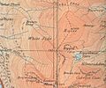
This map from 1925 shows White Side and the areas around it.

