Clough Head facts for kids
Quick facts for kids Clough Head |
|
|---|---|

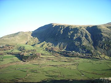
Threlkeld Knotts (left) and Clough Head (centre) showing the craggy western side of the fell
|
|
| Highest point | |
| Elevation | 726 m (2,382 ft) |
| Prominence | 108 m (354 ft) |
| Parent peak | Great Dodd |
| Geography | |
| Location | Cumbria, England |
| Parent range | Lake District, Eastern Fells |
| OS grid | NY333225 |
| Topo map | OS Landranger 90, Explorer OL5 |
Clough Head is a famous hill, or fell, in the beautiful Lake District in England. Its name means 'hill-top above the ravine'. It stands at the northern end of the long Helvellyn range of mountains. Many people enjoy walking along this ridge.
Clough Head is located south of the village of Threlkeld and the A66 road. It forms the steep eastern side of the peaceful valley called St John's in the Vale. On its western side, the fell has dark, rocky cliffs and a deep, rocky valley. The other side has smooth, grassy slopes.
Below the northern face of Clough Head is a steep valley, or 'clough'. This is where the hill gets its name. Also beneath this steep northern face is a smaller hill called Threlkeld Knotts. This granite hill has been quarried a lot around its edges.
Many different types of rocks are found on Clough Head. These rocks formed in very different ways over millions of years. Understanding the rocks here helps you understand much of the geology of the whole Lake District.
An old path called the Old Coach Road runs below Clough Head. Most of the fell is Open Access land. This means walkers can explore freely. You can reach this land from either end of the Old Coach Road or from a lane near Threlkeld village. There are four main paths to the top.
Contents
Exploring Clough Head: A Lake District Hill
Clough Head is 726 meters (about 2,382 feet) high. It is the lowest main peak in the Helvellyn mountain range.
The Slopes and Valleys of Clough Head
The south and east sides of Clough Head have gentle, grassy slopes. These slopes lead down to a wide dip and to Mosedale. These areas separate Clough Head from Great Dodd, its neighbor to the south.
North of the summit, the ground drops very steeply. This slope is covered in loose rocks and cliffs. It marks the northern end of the Helvellyn range. This face is called Red Screes because of the reddish color of its rocks.
Below Red Screes is a smaller, round, grassy hill called Threlkeld Knotts. This hill rises gently from the River Glenderamackin valley. This river separates the Helvellyn fells from Blencathra and the northern Lakeland fells.
A steep valley to the east of Threlkeld Knotts starts right below Red Screes. This is the 'clough' that gives Clough Head its name. At the bottom of this valley, there is a sheepfold called Clough Fold.
Steep, rocky cliffs protect the entire western side of the fell. They rise sharply from the green valley of St John's in the Vale. This western face of Clough Head is rough and very steep. The main rocky features are Buck Castle, Wanthwaite Crags, and Bram Crag.
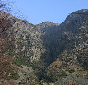
South of Wanthwaite Crags is a very steep path called Fisher's Wife's Rake. It's a grassy break in the cliffs, but it has loose rocks. Determined walkers can use it to climb this side of the fell. North of Bram Crag is a deep, rocky valley called Sandbed Gill. This gill has a lot of water flowing through its rocky gorge. However, the stream often dries up by the time it reaches the valley floor.
North-east of Clough Head's summit is a smaller top called White Pike. From here, the ridge goes down and widens into the rough area of Threlkeld Common.
The western slopes of Clough Head drain into St John's Beck. This beck flows north into the River Greta, which then joins the River Derwent at Keswick. The southern and eastern slopes drain into Mosedale and Mosedale Beck. This beck also joins the River Greta, through the River Glenderamackin.
Threlkeld Knotts: A Smaller Hill with History
Threlkeld Knotts means 'the knobbly hill above Threlkeld'. It is a lower, rounded hill that sits close to the steep northern face of Clough Head. Its curved top has three small peaks, each marked by a pile of stones called a cairn.
From Threlkeld Knotts, you get an amazing view of Red Screes right above you. A narrow path goes up through the cliffs to the west side of Clough Head.
On the northern slope of Threlkeld Knotts, near a large quarry, you can find the remains of an Iron Age settlement. Records show there were seven hut circles, five enclosed areas, two paths, a field system, and about fifty piles of stones. These piles were probably made from clearing rocks from the fields. You can still see parts of the old walls about 200 meters north of the Old Coach Road.
The Historic Old Coach Road
An old path, known as the "Old Coach Road" on maps, crosses the northern slopes of Threlkeld Knotts. It also goes around the eastern side of Clough Head. It reaches a height of 437 meters as it crosses from Wanthwaite in St John's in the Vale to High Row near Dockray.
This road has been damaged by rainwater in recent years. However, it is still a useful path for walkers. Near the highest point of the road is Hause Well, a spring that flows from a crack in the rock. Official signs at both ends of the road show that cars are allowed on it.
Paths to the Summit of Clough Head
Most of Clough Head, Threlkeld Knotts, and Threlkeld Common are Open Access land. This means you can walk freely there. You can enter this land from three places: either end of the Old Coach Road, or from the lane to Newsham Farm. This lane starts across from Threlkeld village. You can also reach it from the old railway line next to the road to the quarry.
Popular Walking Routes
Walkers can reach the summit using four main paths. A narrow footpath leads from the Old Coach Road to White Pike and then to the summit.
Another narrow path starts from Threlkeld Knotts. It goes up through the cliffs and loose rocks of Red Screes. It comes out on the west side of Clough Head. From there, you can walk up gentle grassy slopes to the summit. Many ridge-walkers follow a main path that goes around the top to meet the track from Great Dodd. This means they often bypass the very top.
From the south, the ridge path from Great Dodd goes straight up the long, gentle slope to the summit.
Finally, Fisher's Wife's Rake is a possible way up through the cliffs on the west side of Clough Head. It is for strong and determined walkers, but it is "very steep."
Routes for Experienced Climbers
Experienced climbers can explore the hidden parts of Sandbed Gill. This rocky valley was first climbed by the brothers George and Ashley Abraham in 1890. They were very young but already skilled climbers. This route is challenging and should only be attempted by those with proper climbing experience.
Clough Head is often the first or last stop on a long walk along the Helvellyn range. It can also be part of a longer circular walk around Deepdale. This walk includes the three "Dodds" to its south. This longer walk often starts at High Row and uses the Old Coach Road.
The Summit of Clough Head
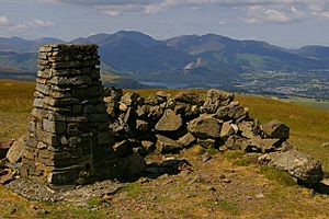
The very top of Clough Head has an Ordnance Survey pillar. This pillar helps mapmakers measure the land. There is also a stone shelter to protect you from the wind.
From the summit, you get a great view of Blencathra to the north. You can see a wide, all-around view, only partly blocked by Great Dodd. On clear days, you might even see the Solway Firth to the north and Morecambe Bay to the south. The view of the high fells to the south-west is especially amazing.
The famous fell-walker Alfred Wainwright drew himself looking at Blencathra from this spot. He included it in his Pictorial Guides to the Lakeland Fells. Some people think White Pike, a smaller peak nearby, offers an even better view for quiet reflection.
The Story of Clough Head's Rocks
The rocks of Clough Head tell a long story. They formed during the Ordovician period, millions of years ago.
Ancient Sea Beds and Volcanic Eruptions
A large crack in the Earth's crust, called a fault, runs just north of the summit. This fault brings two very different types of rock side by side. To the north, including White Pike and much of Threlkeld Common, are rocks that were once mud, silt, and sand. These were laid down in deep water on the edge of an ancient continent. About 460 million years ago, a huge underwater landslide mixed these rocks up.
Later, the land was pushed up above sea level. This was followed by a short but intense period of volcanic activity. This happened about 450 million years ago.
South of the fault on Clough Head are rocks formed from lava flows. These are some of the oldest volcanic rocks in the Lake District. They are part of thick layers of andesite rock. These layers formed from many eruptions of runny lava from volcanoes. Sometimes, the lava changed its type. The geological map shows areas of basaltic andesite on the western cliffs and dacite higher up.
Between the lava flows, there are layers of sandstone. These sandstones formed from eroded volcanic rocks, carried by streams, floods, or even wind. The map shows many such sandstone areas on the western cliffs. A larger area surrounds the summit, where a sheet of andesite rock pushed its way in.
After these lava flows, the magma (molten rock) became thicker and more explosive.
Massive Explosions and Granite Intrusions
In some areas, the older lava flows are covered by rocks from huge volcanic explosions. It seems the whole Lake District was buried under at least 150 meters of very hot gas and rock. This rock is called ignimbrite. These eruptions must have been incredibly powerful, possibly forming a huge volcanic caldera (a large crater) around where Helvellyn is today.
On Clough Head, a small layer of a specific type of volcanic rock covers the summit. This rock is a rhyolite lapilli-tuff. It means it's made of small pieces of semi-molten lava that were flattened by the weight of layers above them.
After the volcanic activity ended, a huge mass of granite pushed its way up into the rocks below the Lake District. Threlkeld Knotts is mostly made of this granite. This granite formed about 451 million years ago.
Quarries and Mineral Veins
Seven quarries around the western side of Threlkeld Knotts have dug out this granite. Besides the large Threlkeld Quarry, there are smaller ones like Birkett Bank and Bramcrag Quarry. Threlkeld Quarry opened in 1870 to provide stones for railway lines. It grew bigger in the 1890s, supplying material for the Thirlmere Reservoir and roads. The quarry closed in the 1980s. Now, it is home to the Threlkeld Quarry and Mining Museum.
Minerals like lead and copper have been found in many Lake District rocks. These minerals formed in veins within cracks in the rocks. This often happened near the large granite mass. Old mining sites for lead and copper ores can be found on Wanthwaite Crag. The most recent mining attempt there was in 1887, but it didn't last long.
The lower part of Threlkeld Knotts, north of Clough Head, has cracks and landslides. From the A66 road and Blencathra, it might look like the whole of Threlkeld Knotts has slid down from the hollow in Clough Head's north face. This hollow is not a true glacial valley, but it's still debated. Similar cracks are also seen on White Pike.
What's in a Name? Clough Head and its Neighbors
Clough Head: The Hill Above the Ravine
Clough Head was once called Threlkeld Fell in a guide book from 1778. Its current name, Clough Head, was first written down in 1867. 'Clough' is an old local word for a ravine or steep valley. This refers to a steep valley just below Red Screes, where there's a sheepfold called Clough Fold. So, Clough Head means "the hill-top above the ravine."
White Pike: The Pale Summit
White Pike means "the pale summit." This name has been used since 1774. It probably got its name from its pale-colored rocks. Perhaps it was named in contrast to the reddish color of Red Screes below the main summit.
Threlkeld Knotts: The Knobbly Hill
Threlkeld Knotts was first recorded in 1900. 'Knott' is an old word from Old Norse meaning 'ball' or 'hard round mass'. It's used for compact or rocky hills. So, Threlkeld Knotts means "the knobbly hill above Threlkeld." The place-name Threlkeld itself is very old, from 1197. It means "the slaves' spring" from Old Norse words. 'Thrall' was a word the Norse settlers might have used for the native Britons.
Fisher's Wife's Rake: Mrs. Fisher's Path
Fisher's Wife's Rake means "Mrs. Fisher's Path." 'Rake' is a local word for a narrow path on a hill. Some say the name comes from the Fisher family who lived across the valley. The story goes that the husband cut peat (a type of fuel) on the hill above, and his wife used a sled to pull it down. However, the source of this story isn't clear.
|
 | William L. Dawson |
 | W. E. B. Du Bois |
 | Harry Belafonte |


