Nethermost Pike facts for kids
Quick facts for kids Nethermost Pike |
|
|---|---|
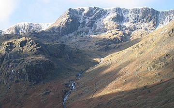
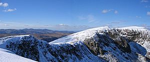
Nethermost Pike from Grisedale
|
|
| Highest point | |
| Elevation | 891 m (2,923 ft) |
| Prominence | 22 m (72 ft) |
| Parent peak | Helvellyn |
| Listing | Wainwright, Nuttall |
| Geography | |
| Location | Cumbria, England |
| Parent range | Lake District, Eastern Fells |
| OS grid | NY343142 |
| Topo map | OS Explorer OL5, Landranger 90 |
Nethermost Pike is a cool mountain, or "fell," found in Cumbria, England. It's part of the amazing Lake District area. This mountain stands tall at 891 meters (2,922 feet) high. It's the second tallest "Wainwright" in the Helvellyn range. The highest peak in this range is Helvellyn itself.
Nethermost Pike is near the southern end of a long mountain ridge. Helvellyn is to its north. To the south, you'll find High Crag and Dollywaggon Pike. Like many mountains in the Eastern Fells, Nethermost Pike sits between Thirlmere lake in the west and the Ullswater area in the east. The closest villages are Glenridding and Patterdale. These villages are on the shores of Ullswater, about 8 kilometers (5 miles) away.
Just like most mountains in the Helvellyn range, Nethermost Pike has grassy slopes on its western side. But on the eastern side, you'll see more rocky areas. Nethermost Pike is made of rocks from the Borrowdale Volcanic Group. Long ago, people even mined for lead on its eastern slopes. You can still see old mining spots there. The eastern slopes are special! They are a Site of Special Scientific Interest. This means they are protected because of their unique rocks and plants. You can find rare "arctic-alpine" plants there.
Contents
What Kind of Mountain Is Nethermost Pike?
Mountains are often grouped by how tall they are. At 891 meters (2,922 feet), Nethermost Pike is called a Nuttall. To be a Nuttall, a mountain needs to be at least 610 meters (2,000 feet) high.
However, Nethermost Pike is not a Hewitt or a Marilyn. These types of mountains need to stick out more from the land around them. Nethermost Pike only sticks out 22 meters (72 feet). Hewitts need to stick out at least 30 meters (98 feet). Marilyns need to stick out 150 meters (492 feet).
Nethermost Pike is also known as a Wainwright. This is because Alfred Wainwright wrote about it in his famous book, Pictorial Guide to the Lakeland Fells. It's the second-highest mountain in the Eastern Fells. It's also the ninth highest of all the Wainwrights.
Just south of Nethermost Pike is High Crag, which is 884 meters (2,900 feet) high. Most guidebooks, like Wainwright's, see High Crag as part of Nethermost Pike. But some people, like author Bill Birkett, think they are separate mountains.
Exploring Nethermost Pike's Shape
The Helvellyn range is a long line of mountains. It runs mostly north to south for about 11 kilometers (7 miles). The whole range stays above 600 meters (1,970 feet) high. Nethermost Pike is near the southern end of this line. Helvellyn is to its north, and Dollywaggon Pike is to its south.
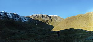
Nethermost Pike has very different western and eastern sides. On the west, the slopes are smooth and covered in grass. Wainwright said: "The grassy western slope... is of little interest." But he added, "From the east, Nethermost Pike is magnificent."
The western slopes gently go down to the Thirlmere reservoir and the tiny church at Wythburn. There are some rougher spots, but mostly it feels like wide-open moorland. The lower parts of the slopes have been planted with pine trees.
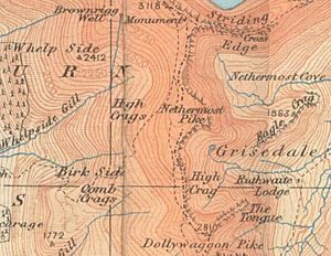
On the east side, it's all about rocks! The long valley of Grisedale goes northeast towards Ullswater. This valley creates several "hanging valleys" that drop from the Helvellyn range.
Southeast of Nethermost Pike, below High Crag, is Ruthwaite Cove. This is a bowl-shaped valley surrounded by cliffs. Inside, you'll find Hard Tarn. This small lake sits on a rocky shelf. It's one of the hardest mountain lakes to find. Its dark bottom and clear water make it look very deep.
Ruthwaite Cove is now home to Ruthwaite Lodge, a hut for climbers. But it used to be a busy mining area. You can still see the remains of old underground mines and open pits near the Lodge.
Between Ruthwaite Cove and Nethermost Cove, Nethermost Pike has a cool rocky ridge. This ridge climbs up with rocky steps for about a kilometer (three-quarters of a mile). It goes straight to the summit. From this side, the mountain really looks like a "Pike," which means a peaked mountain. At the bottom of the ridge is Eagle Crag. It stands above Grisedale Beck, making walkers take a small detour.
North of Nethermost Pike is a dip called Swallow Scarth. From here, the ridge climbs again towards the wide, flat top of Helvellyn. Southwards, the ridge goes down over High Crag. It then gets narrower as it curves east around Ruthwaite Cove to Dollywaggon Pike. A well-used path runs along the ridge. However, it actually goes around the top of Nethermost Pike on the west side, heading straight for Helvellyn.
The very top of Nethermost Pike is shaped like a triangle. It has ridges going north, south, and east. The highest point is towards the northern corner. It's a bit set back from the steep drop into Nethermost Cove. The summit has some scattered stones, but it's mostly covered in rough grass. You'll also see several small piles of stones called cairns.
From the top, the view is amazing! You can see much of the Lake District. Only the huge Helvellyn mountain blocks the view to the north. If you go to the top of High Crag, you can see even more.
How to Climb Nethermost Pike
The Lake District gets over 12 million visitors every year. Many of them come to climb the mountains! The closest villages to Nethermost Pike are Glenridding and Patterdale. They are about 8 kilometers (5 miles) to the east, near Ullswater. Both are popular places to start climbing Nethermost Pike or other mountains in the Helvellyn range.
The best ways to climb from the east are up the east ridge. You can reach it from the path to Eagle Crag Mine. Or you can go via Ruthwaite Lodge and Hard Tarn.
There are no big towns close to Nethermost Pike on the west side. Many walkers start from a car park at Wythburn, near Wythburn Church. This is a popular route. It follows a wide path towards Helvellyn. Then, you turn right at Swallow Scarth. You can try other paths on the smooth sides of the mountain, but they might not be marked.
Because Nethermost Pike is so close to the taller Helvellyn, fewer people visit its very top. When climbing from the west, many people walk across the western slopes on their way to Helvellyn. Even so, the summit still gets many walkers. All these walkers create many different footpaths. This can harm the plants on the summit. Using fewer paths would help protect these plants.
Nethermost Pike's Rocky Past
The rocks at the top of Nethermost Pike are mainly volcaniclastic sandstone. Underneath them are rocks from the Helvellyn Formation. Most of the Lake District's rocks, including Nethermost Pike, are part of the Borrowdale Volcanic Group. These rocks formed a very long time ago, during the Ordovician period.
The eastern cliffs of the Helvellyn range, including Nethermost Pike, have many useful minerals. When these rocks break down, they create rich soil. This soil, along with the area's remote location and climate, helps special plants grow.
People used to mine in Ruthwaite Cove. You can still see the remains of several mine entrances and shallow open pits near Ruthwaite Lodge. Miners were looking for lead here. It's thought they started mining in the 1500s. More mining rights were given out in 1784 and 1862. The last known mining happened in 1880.
Northeast of the summit, in Nethermost Cove, is the Eagle Crag Mine. Here, people mined for lead and zinc. The mineral vein they dug out forms a clear gully on Eagle Crag. They worked this vein both above and below ground, over a height of 300 meters (984 feet). This vein is surrounded by rocks from the Borrowdale Volcanic Group. Huge piles of waste rock from the mining are still found here. These piles contain special crystals called tetrahedrite. It's believed you can't find or collect these crystals anywhere else in Britain! Eagle Crag Mine had a similar mining history to Ruthwaite Lodge.
Amazing Plants and Nature
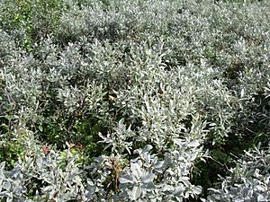
The top of Nethermost Pike and the areas around it are home to many interesting plants and plant groups. Northeast of the summit is Nethermost Cove. This area has some of England's best arctic-alpine and tall-herb plants. It even has one-third of all the Downy Willow plants in England!
Ruthwaite Cove also has arctic-alpine and tall-herb plants. It's thought that this cove might have some very rare plant species. These rare plants exist in very small numbers, which makes them fragile. The lower eastern slopes are called Grisedale Common. This is a large area of low-growing shrubs.
Sheep graze on the lower slopes. This grazing greatly affects what types of plants grow there. Some areas, like Eagle Crag, are too steep for sheep to reach.
The summit and eastern slopes of Nethermost Pike are part of the Helvellyn and Fairfield Site of Special Scientific Interest (SSSI). This SSSI covers a huge area of 2,418.8 hectares (5,977 acres). It's centered on the Helvellyn range and Fairfield. It was chosen in 1975 because of its special rocks and plants. Natural England, which chooses SSSIs, works to make sure the area is managed in a way that protects it for the future.
Too much grazing by sheep in Grisedale Common has damaged the plants. So, careful management has been needed. Since 2003, sheep grazing has been limited. In summer, only one sheep is allowed per hectare (2.5 acres). In winter, it's 0.6 sheep per hectare. In summer, sheep are also kept out of the coves (Nethermost and Ruthwaite). This is because the plants there are easily damaged by summer grazing.
The plants are starting to get better. However, they are recovering slowest on the higher parts of the mountain. The summit is still heavily grazed. The top of the mountain also suffers from erosion because so many walkers climb Nethermost Pike. If walkers used fewer paths, it would help protect the plants on the summit.
 | Leon Lynch |
 | Milton P. Webster |
 | Ferdinand Smith |


