
Red Screes facts for kids
Quick facts for kids Red Screes |
|
|---|---|

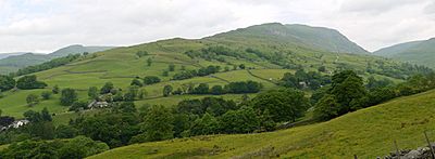
Red Screes seen from Wansfell summit
|
|
| Highest point | |
| Elevation | 776 m (2,546 ft) |
| Prominence | 260 m (850 ft) |
| Parent peak | Fairfield |
| Listing | Marilyn, Wainwright |
| Geography | |

Red Screes
Location in Lake District
|
|
| Location | Cumbria, England |
| Parent range | Lake District, Eastern Fells |
| OS grid | NY396087 |
| Topo map | OS Landrangers 89, 90, Explorer OL7 |
Red Screes is a cool fell (which means a hill or mountain) in the amazing Lake District in England. It sits right between two villages, Patterdale and Ambleside. Even though it's near the Fairfield mountain group, it stands out on its own. This is because it's separated by lower areas called cols. This makes Red Screes feel very independent!
Contents
What Red Screes Looks Like

Red Screes is like a long, narrow ridge of high ground. It stretches for almost 7 kilometers (about 4.3 miles) from Ambleside. At its highest point, it reaches 776 meters (about 2,546 feet) tall. The ridge gets narrower at both ends, making it look a bit like a long, upside-down boat.
It's separated from other nearby fells by two low passes: Scandale Pass to the west and Kirkstone Pass to the east. These passes are quite low, which means Red Screes looks like its own mountain when you see it from the south of the Lake District. Because of these low passes, Red Screes is special enough to be called a Marilyn. This is a type of hill that stands out a lot from the land around it.
There are also two smaller bumps on the ridge. One is Snarker Pike (644 meters) on the south side, and the other is Middle Dodd (654 meters) on the north side. But these bumps don't stick up much from the main ridge.
Water Flow Around the Fell
Red Screes is part of the main watershed of the Lake District. This means that rain falling on one side of the mountain flows in one direction, and rain on the other side flows in a different direction. Water on the north side of Red Screes eventually flows into the Solway Firth. Water on the south side flows into Morecambe Bay.
The edges of Red Screes are shaped by four streams in the valleys nearby. To the south, Scandale Beck and Stock Ghyll flow down the western and eastern slopes. They both join the River Rothay near Ambleside. To the north, Caiston Beck and Kirkstone Beck flow down the western and eastern slopes. They join up where the ground becomes flatter. So, Red Screes is like a big island surrounded by four valleys.
Slopes and Views
The wide southern part of the ridge goes up gently from Ambleside. The lower parts have some small forests and lots of old stone walls. North of the very top, the ridge gets narrower for a bit, then widens again at Middle Dodd. After Middle Dodd, the path goes down steeply, but it's mostly grassy.
The western sides are also rough and grassy, rising steeply from Scandale and Caiston Glen. The eastern side is more rocky. It has two steep, bowl-shaped hollows called corries (or coves in Cumbria). These make the eastern side look very rocky, with long slopes of loose rocks (called scree) above Kirkstone Pass. You can see this clearly from the A592 road that goes over the pass. This is why the mountain is called Red Screes – because the rocks on this side look reddish!
Reaching the Summit
The very top of Red Screes is a wide, flat area with grass and stones. There are two unnamed corries (bowl-shaped hollows) on the eastern side. The highest point is on a flat area between them. You'll find several large piles of stones called cairns, and a special stone pillar used for mapping. There's also a round stone shelter where you can hide from the wind.
Just a few steps south of the top is Red Screes Tarn. This is a small, permanent pond, but no plants grow in it. After it rains, you might see other small puddles. The views from the top are amazing in every direction! You can see Helvellyn very well, and the crags of Dove Crag and Fairfield. You can also spot High Street and the Far Eastern Fells. To the west, you can see distant mountains like Coniston, Bowfell, and Scafell. Looking down the eastern side towards the Kirkstone Inn is a truly spectacular sight!
Paths to the Top
There are popular paths to the summit from four different directions.
- From the South: A clear path goes up the southern ridge directly from Ambleside. You can find it by leaving the main road towards 'The Struggle' about a mile northeast of town. This path goes over Snarker Pike before reaching the top.
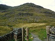
- From the East: A very steep and winding path goes straight up from Kirkstone Pass. This is a favorite route for many visitors. Parts of this path have been repaired with stone blocks because of erosion.
- From the West: The path from Scandale Pass is an easier way to go. You can reach this path from Ambleside or from the north via Caiston Glen.
- From the North: A more direct way is over Middle Dodd, but this path is very steep and not marked. A path appears near the top of Middle Dodd and then leads along the northern ridge to the summit of Red Screes.
The Rocks of Red Screes
All the rocks that make up Red Screes are part of something called the Borrowdale Volcanic Group. These rocks formed about 450 million years ago, during a time when there was a lot of volcanic activity. Imagine huge volcanoes erupting!
The oldest rocks are at the bottom of the fell. They are called the Seathwaite Fell Sandstone Formation. These are mostly sandstone and siltstone, which are types of rock made from tiny bits of sand and mud that settled in shallow water. Sometimes, there are also layers of volcanic ash mixed in, showing that volcanoes were still active.
Above these older rocks are the Lincomb Tarns Tuff Formation. These rocks are mainly made of volcanic ash and small rock fragments that were blasted out of volcanoes and then stuck together. This type of rock covers a huge area in the Lake District, meaning there must have been some truly massive volcanic eruptions!
You can also find rocks from the Borrowdale Sill Suite mixed in with the other layers. These are andesite rocks that pushed their way into existing cracks in the ground during the volcanic period.
Higher up on the northern ridge, you'll find rocks from the Esk Pike Sandstone Formation. These are layers of pebbly sandstone and finer mudstone. This shows that rivers and lakes returned to the area after the main volcanic activity.
The highest and youngest rocks on Red Screes are the Middle Dodd Dacite Formation. These are white-colored lava rocks found near the top of Middle Dodd. They formed from thick, sticky lava that flowed from a volcano, perhaps filling in old dips in the land.
After the last ice age, a lot of loose material called till (a mix of clay, sand, gravel, and boulders) was left behind by glaciers. You can find this on the lower slopes and on top of the ridge of Red Screes.
Quarries and Mines
There's a noticeable quarry on the southeast side of Red Screes, below Kirkstone Pass, called Kirkstone Quarry (or Pets Quarry on maps). This quarry used to dig out green and blue-black slate, which is a type of rock used for building. The company that ran it had some problems in 2012, but the stone is still sold today. The slate comes from the Seathwaite Fell Sandstone Formation, where fine-grained rocks were changed into slate by heat and pressure.
You can also see the remains of a small quarry on the western slopes. This was used to get stones for building walls. There's even a old track where sleds would carry stones down to the fields in Scandale.
In Caiston Glen, there's evidence of old mining. You can see the entrance to a tunnel that goes about 80 feet into the hillside. This was an unsuccessful attempt to find lead. There's another small digging nearby.
On the eastern side, close to the modern road, there are also remains of a tunnel dug about 120 feet into the fell. This was a trial to find copper.
What the Names Mean
Red Screes
The name Red Screes comes from the mountain itself! The steep eastern slopes, which are covered in loose rocks (scree), often look reddish.
Snarker Pike
Snarker Pike probably means 'snake peak'. The word snaca is an Old English word for snake. In 1764, it was even called Snake Pike. It might have originally been 'Snake How', with 'how' meaning a hill. It's a bit strange to link it to snakes, even though adders (a type of snake) can be found in the Lake District. 'Pike' is a local word for a peak or summit.
Middle Dodd
Middle Dodd is the middle one of three "dodds" you can see from Hartsop Hall. The others are (Low) Hartsop Dodd and High Hartsop Dodd. Their names don't mean they are taller or shorter, but where they are in the valley. 'Dod' or 'dodd' is a local word for a bare, rounded summit, often a smaller part of a bigger mountain.
Image gallery
-
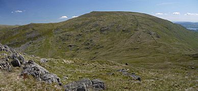
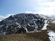
Looking up the broad south ridge of Red Screes to Snarker Pike and the summit, from near Ambleside.
-
Looking over Scandale Pass to Red Screes. Middle Dodd is on the left.


-
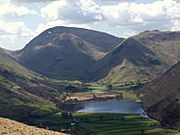
Red Screes and Middle Dodd seen beyond Brothers Water from the Patterdale Valley. On the right is High Hartsop Dodd.
-
The north ridge: Middle Dodd and Red Screes, seen from Hartsop-above-How
-
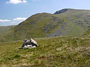
Looking up to the summit of Red Screes from Middle Dodd
-
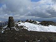
The summit of Red Screes
-
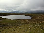
The summit Tarn on Red Screes
-
Red Screes seen from the car park on Kirkstone Pass
-
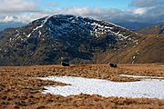
Red Screes seen from Cauldale Moor. Notice the unnamed cove below the summit.
-
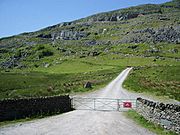
Entrance to Kirkstone Quarry


