River Rothay facts for kids
The River Rothay is a beautiful river located in the Lake District in northwest England. Its name comes from an old language called Old Norse, and it means "the red one." Over time, this name also became known as "trout river," perhaps because of the reddish color of the water or the fish found there. The Rothay is a "spate river," which means its water level can rise and fall quickly, especially after heavy rain.
Contents
Where Does the River Rothay Start?
The River Rothay begins high up in the mountains, near a place called Rough Crag. This spot is about 1,542 feet (470 meters) above sea level, close to Dunmail Raise. The area where the river collects its water, known as its catchment area, includes places like Grasmere Common, Easedale Tarn, and the southern parts of Fairfield. It also gathers water from other hills east of Dunmail Raise, such as Great Rigg, Rydal Fell, Scandale Fell, and Heron Pike.
The Journey of the Rothay River
From its source, the Rothay flows down through a valley called Greenburn Bottom. It passes by a small village named Helmside, which is not far from the main A591 road.
Flowing Through Grasmere
Just north of the village of Grasmere, the Rothay is joined by two smaller streams: Easedale Gill and Sour Milk Gill. Sour Milk Gill flows out of Easedale Tarn. In Grasmere village, the river flows very close to the churchyard where the famous poet William Wordsworth is buried.
The Rothay then flows into the northern end of Grasmere lake, which is about 208 feet (63 meters) above sea level. The river both fills Grasmere lake and drains it.
Connecting Lakes: Grasmere to Rydal Water
After leaving Grasmere, the Rothay flows for only about half a mile (800 meters). It then enters Rydal Water at its western end. Rydal Water is a bit lower, at 181 feet (55 meters) above sea level. The Rothay also drains Rydal Water from its eastern side.
Towards Windermere
From Rydal Water, the river flows generally south for about three miles (4.8 kilometers). It then meets another river, the River Brathay, at a place called Croft Lodge, southwest of Ambleside. From this meeting point, the combined rivers flow into the northern end of Windermere, which is one of the largest lakes in England.
Fun Activities on the River Rothay
The River Rothay is a popular spot for outdoor activities.
Stepping Stones and Canoeing
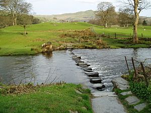
About a mile (1.6 kilometers) north of Ambleside, you can find a well-known set of stepping stones that cross the Rothay. These are fun to walk across!
Many parts of the Rothay are also popular with canoeists. The section between Grasmere and Rydal Water is especially good for canoeing and is rated as a 2+ difficulty, which means it has some exciting rapids but is generally suitable for those with some experience.
Fishing for Trout
The Rothay is also a great place for fishing, especially for brown trout. If you want to go fishing, you'll need to check with local authorities about getting the right permits. An Environment Agency Rod Licence is always required.
The Rothay's Place in History
Historically, the River Rothay was entirely within the old county of Westmorland. However, after some changes to local government in 1974, the river is now part of the county of Cumbria.
 | Precious Adams |
 | Lauren Anderson |
 | Janet Collins |


