High Street (Lake District) facts for kids
Quick facts for kids High Street |
|
|---|---|

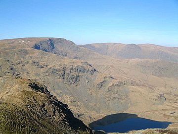
High Street seen from Harter Fell with
Small Water in the foreground |
|
| Highest point | |
| Elevation | 828 m (2,717 ft) |
| Prominence | 373 m (1,224 ft) |
| Parent peak | Helvellyn |
| Listing | Marilyn, Hewitt, Wainwright, Nuttall |
| Geography | |
| Location | Cumbria, England |
| Parent range | Lake District, Far Eastern Fells |
| OS grid | NY440110 |
| Topo map | OS Explorer OL5 |
High Street is a tall hill, also called a fell, in the beautiful Lake District in England. It stands at 828 meters (2,718 feet) high. This makes it the highest point in the far eastern part of the national park. High Street got its name from an old Roman road that actually ran right over its top!
Contents
A Road from Roman Times
Long ago, the Romans built a road that crossed High Street. This road connected their forts at Brougham (near Penrith) and Ambleside. The High Street area has gentle slopes and a flat top. These features were perfect for the Romans.
They chose to build their road over the fell tops. This was because the valleys below were full of thick forests and marshy ground. Such places could hide dangers like ambushes. Building on the high, open ground was much safer for Roman travelers.
Fun Fairs on the Summit
In the 1700s and 1800s, the flat top of High Street became a place for summer fairs. Local people would gather there every year on July 12th. One main reason was to return any lost sheep to their owners.
But it wasn't all work! People also enjoyed games and wrestling. Horse racing was a very popular event. Even today, the summit of High Street is known as Racecourse Hill on maps. You might even see fell ponies grazing there sometimes. The last of these lively summer fairs happened in 1835.
Rivers and Lakes
The River Kent starts its journey on the southern slopes of High Street. This river flows south through the town of Kendal. It then empties into Morecambe Bay. The River Kent drops about 300 meters (1,000 feet) over 40 kilometers (25 miles). This makes it known as one of the fastest-flowing rivers in England.
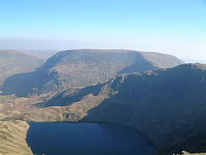
The eastern side of High Street is very steep and rocky. It drops sharply towards Haweswater Reservoir. Below these rocky cliffs, you'll find two beautiful mountain lakes, called tarns. These are Blea Water and Small Water. Blea Water sits in a classic mountain corrie (a bowl-shaped hollow). It is also the deepest tarn in the Lake District, reaching 200 feet deep!
The Summit View
A stone wall runs along the ridge over the flat top of High Street. The very highest point is marked by a white Ordnance Survey triangulation column. From the summit, you can see amazing views.
To the east, you can spot the Pennines mountain range. To the west, a huge curve of Lakeland hills fills the horizon. The Helvellyn range and the Southern Fells look especially impressive from here.
Climbing High Street
There are several ways to climb High Street. One exciting way is from Mardale. This climb follows a ridge, offering great views down into Riggindale. In the past, you might have even seen a golden eagle there. However, the last known golden eagle in England, a male, has not been seen since 2016.
You can also climb High Street from places like Patterdale, Kentmere, and Troutbeck. There is a very long walk that goes from south to north along the High Street ridge. It starts near Windermere and ends at the northern end of Ullswater. This hike is about 30 kilometers (18.6 miles) long and crosses twelve different summits. It should only be attempted by experienced walkers.
 | Aaron Henry |
 | T. R. M. Howard |
 | Jesse Jackson |


