
Southern Fells facts for kids
The Southern Fells are a group of mountains and hills in the English Lake District. They include Scafell Pike, which is the highest mountain in England. These fells cover a large area south of Great Langdale, Borrowdale, and Wasdale. The mountains in the middle of the Lake District are high and rocky. As you go southwest, they become more like moorland. In the southeast, you'll find the famous Furness Fells. These fells have many old quarries and rise above Coniston Water.
Contents
Exploring the Lakeland Fells: How They Are Divided
The Lake District is a special National Park in northwest England. It has many beautiful lakes and a complex range of hills. These hills are often called fells by local people. They range from small hills to the tallest peaks in England. There are hundreds of these hilltops. Many writers have tried to make official lists of them. To make it easier to describe, they often divide the area into smaller parts.
One of the most important writers was Alfred Wainwright. His book series, Pictorial Guide to the Lakeland Fells, has sold over 2 million copies. It has been printed continuously since 1952. Wainwright divided the fells into seven main areas. Each area is surrounded by valleys and low passes. While other writers have made their own divisions, Wainwright's seven areas are still the most well-known. The Southern Fells are one of these areas. They are covered in Volume 4 of Wainwright's books.
Understanding the Southern Fells' Borders
Deciding where the Southern Fells begin and end can be tricky. Wainwright, the famous guidebook writer, chose to leave out some areas. He felt that the scenery changed too much south and west of Green Crag. He also made similar choices for the fells south of Dow Crag. However, he later included these areas in another book called "The Outlying Fells of Lakeland."
The northern borders are much clearer. They start at Wastwater in the west. Then they go up past Wasdale Head to Sty Head Pass. This pass is a popular route for walkers going to Borrowdale. On this side, you'll find Great Gable and the Western Fells. The border continues north to Stonethwaite in Borrowdale. Then it turns southeast along the Langstrath valley. This includes the long ridge of Glaramara within the Southern Fells. At the end of Langstrath, the border crosses Stake Pass. This is another path for walkers. It then goes east down Great Langdale to Windermere. Stake Pass connects to the Langdale Pikes in the Central Fells.
Discovering the Mountains and Valleys of the Southern Fells
The Southern Fells cover a wide part of the Lake District. They stretch about 10 kilometers (6 miles) in every direction. Besides the valleys around the edges, Eskdale and the Duddon Valley also divide the area. These valleys flow out from the center of the district.

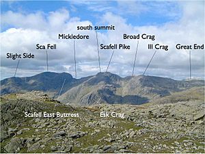
In the north, around the top of Eskdale, are the Scafells. These high mountains also stand above the valleys of Wasdale, Borrowdale, and Great Langdale. This area is open to the south and has England's highest ground. The range starts in the west with Slight Side. Then it rises to the peaks of Scafell, Scafell Pike, and Great End. Across the dip of Esk Hause, on the east side of Eskdale, are Esk Pike, Bowfell, and Crinkle Crags. Smaller mountains connected to this main ridge include Lingmell above Wasdale. There is also the Allen Crags- Glaramara- Rosthwaite Fell ridge. This ridge goes deep into Borrowdale. East of Bowfell is Rossett Pike, which links to the Central Fells. Illgill Head and Whin Rigg are also part of this area. These fells form the famous Wastwater Screes.
South from Crinkle Crags, between Eskdale and the Duddon, are Hard Knott, Harter Fell, and Green Crag. Another ridge goes southeast from Crinkles. It passes over Cold Pike and Pike O'Blisco. Then it crosses the road at Wrynose Pass. After that, it rises to Great Carrs. This is the first of the Coniston, or Furness, Fells. The rest of this group includes Swirl How, Grey Friar, Wetherlam, Brim Fell, Coniston Old Man, and Dow Crag. Together, they form the divide between Coniston and the Duddon valleys. To the east are the lower hills of Holme Fell and Black Fell.

Getting Around: Access for Walkers
You can reach the high Southern Fells from many main walking spots in the Lake District. These include the tops of Wasdale, Borrowdale, Langdale, and Eskdale. Paths like Sty Head, the Stake, Rossett Gill, Grains Gill, Burnmoor Tarn, and Esk Hause connect all these valleys. These valleys are many miles apart by road.
The main paths from Seathwaite or Wasdale Head to Scafell Pike are very popular. So is the path from Great Langdale up Bowfell. The 'Tourist Route' up Coniston Old Man is also very busy. These popular spots will have many people almost any day of the year. However, if you go away from these famous peaks, especially to the south, you can find quieter walks.
