
Whin Rigg facts for kids
Quick facts for kids Whin Rigg |
|
|---|---|

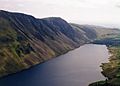
Whin Rigg and The Screes seen across Wast Water from Middle Fell.
|
|
| Highest point | |
| Elevation | 535 m (1,755 ft) |
| Prominence | c. 58 m |
| Parent peak | Illgill Head |
| Listing | Wainwright |
| Geography | |

Whin Rigg
Location in Lake District

Whin Rigg
Location in the Borough of Copeland
|
|
| Location | Cumbria, England |
| Parent range | Lake District, Southern Fells |
| OS grid | NY151034 |
| Topo map | OS Landranger 89 OS Explorer OL6 |
Whin Rigg is a beautiful fell (which is another word for a hill or mountain) located in the western part of the Lake District in England. It's about 22 kilometers southeast of Whitehaven. Even though it's not the tallest at 535 meters (1,755 feet) high, Whin Rigg is famous for its amazing views.
One of the most exciting features is the Wastwater Screes. These are huge, rugged slopes of loose rocks that drop dramatically from the top of Whin Rigg down to Wast Water, which is over 450 meters (1,500 feet) below! The name "Whin Rigg" comes from old Norse words. "Hvin" means gorse (a spiky, yellow-flowered bush), and "Hryggr" means ridge. So, Whin Rigg means "gorse-covered ridge."
Contents
Exploring Whin Rigg's Landscape
Whin Rigg is connected to another fell called Illgill Head. They are only about 1.5 kilometers apart. A path links them, offering incredible views looking straight down to Wast Water.
The Amazing Screes
The Wastwater Screes are a very special place for geology. They are known as one of the best and most famous examples of "screes" in all of Britain! A scree is a slope covered with broken rock pieces. The cliffs and screes here are made of very strong rock called Borrowdale Volcanics. However, some parts of the rock are softer and have worn away over time. This has created deep channels, or gullies, in the cliff face.
Near the top of Whin Rigg, the cliffs are like tall, straight rock walls. These walls are split by two huge gullies called Great Gully and C Gully. Looking down these gullies gives you a dizzying view of Wast Water below! These gullies are spectacular to see, but they are very dangerous for walkers. Great Gully, for example, has seventeen almost vertical drops. There are even parts of an old airplane found inside it!
Greathall Gill: A Natural Wonder
Besides the famous Screes, Whin Rigg has another cool natural feature called Greathall Gill. This is a granite ravine, which is a deep, narrow valley with steep sides. It starts where the River Irt flows out of Wast Water and goes up the fell to about 400 meters high, southwest of the summit.
The lower part of Greathall Gill is steep and covered with trees. It's home to many different plants, including mosses, ferns, and herbs. You can find plants like Common wood sorrel and great wood rush growing here.
Climbing Whin Rigg
There are a few ways to climb Whin Rigg. One popular path goes up the eastern side of Greathall Gill. This path starts from Nether Wasdale in Wasdale. It has become a bit worn down over the years, but people are watching it to make sure it doesn't get worse.
You can also start your climb from Nether Wasdale or from Eskdale Green in Eskdale. There's a special path called a bridleway that connects these two places. This path leads you to the western ridge of the fell. From there, it's about 230 meters (750 feet) more to climb up the ridge to reach the very top.
Views from the Summit
When you reach the top of Whin Rigg, the best part is the amazing view looking down at Wast Water. It's truly breathtaking! You can also see the flat land near the coast and even catch a glimpse of the Isle of Man on a clear day.

-
View from Yewbarrow
-
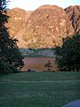
Wastwater and Whin Rigg lit up by the setting sun
-
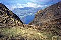
A dizzying view of Wastwater looking down Great Gully from the top of Whin Rigg.


