Middle Fell facts for kids
Quick facts for kids Middle Fell |
|
|---|---|
| Highest point | |
| Elevation | 582 m (1,909 ft) |
| Prominence | c. 117 m |
| Listing | Wainwright |
| Geography | |
| Location | Cumbria, England |
| Parent range | Lake District, Western Fells |
| OS grid | NY151072 |
| Topo map | OS Landranger 89, 90, Explorer OL6 |
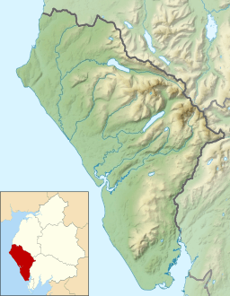
Middle Fell is a cool hill, also called a 'fell,' located in the amazing Lake District in England. It's like a smaller friend to a bigger hill called Seatallan. Middle Fell stands proudly above the north side of Wastwater, a beautiful lake. You can climb Middle Fell from a place called Greendale, which is near the bottom of Wastwater. From the top, you get an awesome view of the lake with the tall, rocky 'Screes' behind it!
Contents
Where is Middle Fell Located?
The Western Fells are a group of hills in the Lake District. They form a triangle shape. Rivers like the River Cocker and the area called Wasdale border them. Towards the west, these hills get smaller as they reach the flat coastal land.
How Middle Fell Connects to Other Hills
The main line of high ground goes west from Great Gable. This line separates the streams that flow into Ennerdale from those that flow into Wasdale. Along this line, you'll find big hills like Kirk Fell, Pillar, Scoat Fell, Haycock, and Caw Fell.
Haycock has a long ridge that goes south. This ridge ends at Seatallan. Middle Fell is like a smaller branch that comes off Seatallan towards the southeast.
Valleys Around Middle Fell
Middle Fell starts at a low point, or 'col,' on the east side of Seatallan. This spot is about 1,525 feet high. This is the only place where Middle Fell connects to other high ground. Deep valleys surround it on three sides.
To the west, Greendale Gill separates Middle Fell from Seatallan. This stream starts at Greendale Tarn. A 'tarn' is a small mountain lake. Greendale Tarn is about 30 feet deep. It sits in a long, narrow basin with huge rocks around it.
To the east, you'll find Nether Beck. This stream flows down its long valley to Wastwater. On the other side of Nether Beck are the long southern slopes of Red Pike.
Middle Fell's Slopes
The southern slopes of Middle Fell reach down to the shore of Wastwater. They cover a long part of the northern shore. This area is between Nether Beck Bridge and the Greendale road junction. Other streams like Goat Gill and Smithy Beck also drain water from this side.
Middle Fell has steep sides all around. The western side is rough with loose rocks and boulders. However, it doesn't have many big cliffs. The eastern slopes are longer and have many layers of rocks. Some of the main rocky areas are called Long, Water, Goat, Foegill, and Iron Crags. The ridge that goes north to Seatallan is wide. It becomes grassy after a rough start downhill.
What is Middle Fell Made Of?
The top part of Middle Fell is made of a type of rock called 'dacitic, welded lapilli tuff.' This rock is part of the Lincomb Tarns Formation. You can also find 'andesitic lapilli tuff' at both ends of the ridge. There are also small amounts of 'basalt' and 'dolerite' rock. Underneath all of this is the Birker Fell Formation. This layer is made of 'plagioclase-phyric andesite lavas.'
What Can You See From the Top?
The very top of Middle Fell has a stone pile, called a 'cairn.' It sits on a small rocky area. This spot is close to where the ridge starts to go down to the south.
From the summit, you get an amazing view across Wastwater. You can clearly see the rocky 'screes' of Whin Rigg and Illgill Head. You can also see the top part of Wasdale. Further away, you might spot the Coniston Fells. Even farther off to the southwest, you can see Black Combe.
How to Climb Middle Fell
The easiest way to climb Middle Fell is to follow a path up the front of the ridge. This path starts at Greendale.
A longer way to climb is to follow the stream up to Greendale Tarn. From there, you can turn back and follow the Seatallan ridge to the summit. You can also make a bigger loop by including Seatallan and Buckbarrow in your hike.
 | Janet Taylor Pickett |
 | Synthia Saint James |
 | Howardena Pindell |
 | Faith Ringgold |


