Scoat Fell facts for kids
Quick facts for kids Scoat Fell |
|
|---|---|
 |
|
| Highest point | |
| Elevation | 841 m (2,759 ft) |
| Prominence | c. 46 m |
| Parent peak | Pillar |
| Listing | Nuttall, Hewitt, Wainwright |
| Geography | |
| Location | Cumbria, England |
| Parent range | Lake District, Western Fells |
| OS grid | NY159113 |
| Topo map | OS Landranger 89, Explorer OL4 |
| Listed summits of Scoat Fell | ||||
| Name | Grid ref | Height | Status | |
|---|---|---|---|---|
| Black Crag | NY165116 | 828 m (2,716 ft) | Hewitt | |
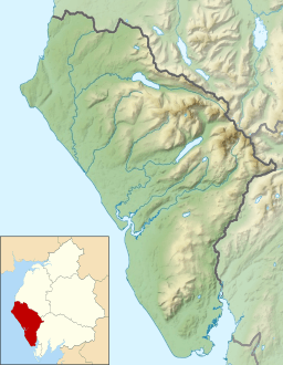
Scoat Fell is a cool mountain, or 'fell,' located in the western part of England's Lake District. It sits at the top of a horseshoe-shaped valley called Mosedale, with the Ennerdale valley behind it. You can hike to Scoat Fell from different directions. Some paths come from Ennerdale, going over another peak called Steeple. Others come from Wasdale, passing Red Pike. You can also follow a ridge from Pillar mountain.
Contents
Where is Scoat Fell Located?
The Western Fells are a group of mountains in the Lake District. They form a triangle shape, with the River Cocker on one side and Wasdale on another. As you go west, the hills get smaller towards the coast.
Scoat Fell is part of the southern arm of a big horseshoe shape of mountains. This horseshoe wraps around the long, wild valley of Ennerdale.
Important Mountain Connections
Scoat Fell is like a central point where five different mountain ridges meet.
- To the east, past a smaller peak called Black Crag, is Pillar.
- To the south, a long ridge goes down towards the shore of Wastwater. The highest point on this ridge is Red Pike, before it ends at Yewbarrow.
- The main ridge continues west to Haycock.
- Two shorter ridges stick out north into Ennerdale. These are Tewit How and Steeple.
Valleys and Coves Around Scoat Fell
Because so many ridges meet at Scoat Fell, it's the starting point for several valleys.
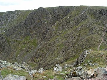
- Mosedale valley begins on the eastern side of Scoat Fell, between Red Pike and Pillar. It has steep cliffs called crags.
- Nether Beck valley starts at Scoat Tarn. This is a large, deep mountain lake (called a tarn) south of the fell.
- Between Steeple and Pillar to the north is Windgap Cove. This area has Black Crag, which is also a Hewitt (a type of mountain).
- Wind Gap is the low point (or col) between Black Crag and Pillar.
- Mirk Cove is a small area between Black Crag and the very top of Scoat Fell.
- Mirklin Cove is another steep-sided valley between Steeple and Tewit How. It drains into Ennerdale. All the northern coves have impressive crags.
Smaller Peaks Near Scoat Fell
Some smaller peaks, like Little Scoat Fell and Black Fell, are usually thought of as part of Scoat Fell itself. However, Steeple, even though it's very close, is considered a separate mountain. This is because it looks so impressive from Ennerdale, not because it's much higher.
What Scoat Fell is Made Of
If you look at the ridge of Tewit How to the northwest, you can see different layers of rock.
- At the top, there's a type of volcanic rock called andesite lava.
- Below that are layers of siltstone, sandstone, and other volcanic ash rocks.
- Further down, you'll find more volcanic rock and then dacite.
- Finally, there are igneous rocks from the Ennerdale Intrusion.
The Top of Scoat Fell
The very top of Scoat Fell is a long, flat area that runs from east to west. A stone wall, called the Ennerdale fence, crosses right over the summit. Hikers have built a small pile of stones (a cairn) on top of this wall. A larger cairn nearby points the way to Steeple. The whole area at the top is quite rocky.
You get great views into the valleys to the north. While Pillar mountain blocks some of the view, you can still see almost the entire horseshoe shape of the Western Fells. The wall on the summit makes it a bit tricky to see everything from one spot.
How to Hike Scoat Fell
There are several ways to reach the top of Scoat Fell:
- From Ennerdale, many hikers go indirectly by climbing Steeple first. You can also use the ridge of Tewit How.
- Wasdale Head is another good starting point. You can walk up Mosedale valley and then climb to the ridge via Black Comb.
- Nether Beck Bridge, near Wastwater, gives you access through Scoat Tarn onto the southern slopes. From the upper part of Nether Beck, you can aim for the low points that connect Scoat Fell to Red Pike or Haycock.
- Many people visit Scoat Fell as part of the Mosedale Horseshoe hike. This popular route also includes climbing Red Pike and Pillar.
 | Emma Amos |
 | Edward Mitchell Bannister |
 | Larry D. Alexander |
 | Ernie Barnes |


