
Black Combe facts for kids
Quick facts for kids Black Combe |
|
|---|---|

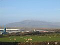
Black Combe seen across the Duddon Estuary from Foxfield
|
|
| Highest point | |
| Elevation | 600 m (2,000 ft) |
| Prominence | 362 m (1,188 ft) |
| Parent peak | Scafell Pike |
| Listing | Marilyn, Outlying Wainwright |
| Geography | |

Black Combe
Location in Lake District

Black Combe
Location in the Borough of Copeland
|
|
| Location | Lake District, England |
| OS grid | SD135854 |
| Topo map | OS Landranger 96 |
Black Combe is a tall hill, also called a fell, located in the southwest part of the Lake District National Park in England. It's only about four miles from the Irish Sea. This hill is in Cumbria, near the coast, and is 1,970 feet (600 meters) high.
Black Combe stands alone, far from other tall hills. This means you can see amazing views all around, covering both land and sea, if the weather is clear. It is known as a Marilyn because it stands out a lot from the land around it.
Contents
Amazing Views from Black Combe
The view from Black Combe is very special. This is because it stands by itself, away from the main hills of the Lake District.
Seeing the Sea and Distant Lands
When you look towards the sea, you can see the sparkling water. The Isle of Man is often clearly visible to the west. On very clear days, you might even spot the hills of Wales and Scotland far away.
The views along the coast stretch from Cumbria all the way to Lancashire. You can see Criffel, a mountain in Scotland, and even Snowdon in Wales if the visibility is excellent.
Seeing the Lake District and Beyond
Looking inland, you can see many famous hills in the Lake District National Park. These include the Scafell Group and the Coniston Group. You might even spot four very tall mountains: Skiddaw, Scafell, Scafell Pike, and Helvellyn.
Further away, to the east and south, you can see the Pennine Hills and the Forest of Bowland. Closer by, there are great views over the Duddon Estuary, the town of Millom, and a new wind farm just offshore.
How Black Combe Got Its Name
If you look at Black Combe from the south or east, you can clearly see a large, dark-colored glacial corrie. This is a bowl-shaped hollow made by a glacier. This corrie is called Blackcombe, and it's where the hill gets its name. A "combe" is a word for a valley or hollow, similar to the Welsh word cwm. Right next to Blackcombe, there's a lighter-colored corrie called Whitecombe.
History and Activities
Black Combe was an important spot for early mapmakers. The Ordnance Survey used it as one of their main stations to measure angles for their first maps of Britain around 1809.
Festivals and Races
Every June, the Black Combe Walking Festival takes place, where people enjoy walks around the area. There's also the Black Combe fell race, a running competition held in early March.
Ancient Stone Circle
On the eastern side of Black Combe, on Swinside Fell, you can find the Swinside stone circle. It's also known as the Sunken Kirk. This is an ancient monument made of large stones arranged in a circle.
Black Combe's Rocks
The rocks that make up Black Combe are very old. They were formed during the Ordovician period, about 460 million years ago. These rocks are mostly mudstones and siltstones. They were created in deep seas when mud and sand from the coast slid down into the ocean.
You can learn more about these rocks at Millom Rock Park, which is open to the public.
Walking Routes to the Top
There are several ways to walk to the top of Black Combe.
Starting Points
You can begin your walk from St Mary's Church, Whicham to the south, or from St Mary's Church, Whitbeck to the west. Another option is to start from the Corney Fell Road, which crosses the hills to the north.
A more exciting route starts at Beckside Farm on the A595 road. This path follows Whitecombe Beck and then climbs up a ridge called Horse Back. This ridge is between Blackcombe and Whitecombe, offering great views into both hollows.
The Summit of Black Combe
The very top of Black Combe is a wide, flat area covered in peat. There is a Triangulation Pillar at the summit, which is a concrete pillar used for surveying. It's surrounded by a rough stone wall that helps block the wind.
A little south of the main peak, there's another smaller peak with a large cairn (a pile of stones). You can easily see this cairn from Millom. Between this cairn and the main top, in a small dip, there's a tiny lake called a tarn.
Wainwright's Guide
Black Combe is featured in Wainwright's book The Outlying Fells of Lakeland. Wainwright was a famous fell walker and author. In his book, he describes three different ways to climb Black Combe: from the south, west, and north. He also includes a walk around White Combe to the east.
Images for kids
-
Black Combe viewed over the Duddon Estuary from Barrow-in-Furness
-
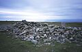
The sprawling cairn on the wide summit of Black Combe


