
Caw Fell facts for kids
Quick facts for kids Caw Fell |
|
|---|---|

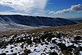
Caw Fell from the ridge leading up from Ennerdale
|
|
| Highest point | |
| Elevation | 697 m (2,287 ft) |
| Prominence | c. 22 m |
| Parent peak | Haycock |
| Listing | Wainwright, Nuttall |
| Geography | |

Caw Fell
Location in Lake District

Caw Fell
Location in the Borough of Copeland
|
|
| Location | Cumbria, England |
| Parent range | Lake District, Western Fells |
| OS grid | NY132109 |
| Topo map | OS Landranger 89, 90, Explorer OL4, OL6 |
| Listed summits of Caw Fell | ||||
| Name | Grid ref | Height | Status | |
|---|---|---|---|---|
| Iron Crag | NY123119 | 640 m (2,099 ft) | Hewitt | |
Caw Fell is a mountain in the beautiful Lake District in England. It's located between two other hills, Haycock and the Lank Rigg group. This mountain covers a large area with the Ennerdale valley to its north and Blengdale to its south. Caw Fell is a bit far from easy starting points. However, you can still climb it from car parks in Blengdale or Bowness Knott.
Contents
Exploring Caw Fell: A Western Lake District Mountain
Caw Fell is part of the Western Fells, a group of mountains in the Lake District. These hills form a triangle shape. To the west, they get smaller as they reach the coast. The highest points in this area are around Great Gable. From there, two main ridges spread out around Ennerdale, making the western fells look like a big horseshoe. Caw Fell sits on the southern part of this horseshoe.
Understanding the Mountain's Shape
The main ridge of mountains goes west from Great Gable. It separates the streams that flow into Ennerdale and Wasdale. Key mountains on this ridge include Kirk Fell, Pillar, Scoat Fell, Haycock, and Caw Fell. As you move west, the valleys get wider. By the time you reach Caw Fell, they are about 6 miles apart. Other rivers start here, draining the land in between. The River Bleng begins south of Caw Fell. Worm Gill drains the western slopes.
Caw Fell is the end of this western ridge. The ridge then turns north around the top of Worm Gill. It crosses a smaller peak called Iron Crag before reaching Crag Fell and Lank Rigg.
Features of Caw Fell's Slopes
The flat area connecting Caw Fell to Haycock is called a col. An old stone wall, known as the Ennerdale Fence, runs across this col. Tongue Gill, a main stream of the River Bleng, starts on the south side of this saddle. On the other side is Silver Cove, a deep, enclosed valley that leads into Ennerdale. A heathery ridge called Tongue End runs next to it.
West of the summit, a wide ridge drops steeply to Worm Gill. There's a rocky hollow on the northern side above Bleaberry Gill. The ridge of Iron Crag runs north between this hollow and Silver Cove. This makes the top of Caw Fell look like an upside-down 'T'. A narrow, steep col (a low point between two peaks) at 1,575 feet makes Iron Crag stand out more than its parent peak. A small tarn (a mountain lake) is found on Iron Crag's northern slope. The rock face that gives Iron Crag its name overlooks Silver Cove. From Iron Crag, the ridge turns west again. Its rough northern sides run above the shore of Ennerdale Water. Important spots here include Mart Knott, Stair Knott, and Boat How. This ridge then meets the streams of the River Calder. It splits to go around the valley, with Crag Fell to the north and Lank Rigg to the south.
Caw Fell also has a lower ridge to the southwest. This ridge goes down between the River Bleng and Worm Gill. It first reaches Stockdale Moor. This area is full of old burial mounds, hut circles, and other signs of ancient homes. Beyond this are the lower hills around Ponsonby Fell (1,033 feet). These hills are not included in Alfred Wainwright's famous guidebooks. However, other guidebooks do cover them.
The Rocks Beneath Caw Fell
The northeastern parts of Caw Fell are covered by loose soil and rocks. Beneath these are lava rocks from the Birker Fell Formation. The rest of the mountain is made of granite from the Ennerdale Intrusion.
A place called Iron Crag Mine operated below Iron Crag from about 1864 to 1896. In 1881, 500 tons of iron ore were dug up. But the mine never made much money. Other smaller mining operations also ran briefly in Silver Cove and Deep Gill.
Reaching the Top of Caw Fell
The very top of Caw Fell is north of the stone wall. It's marked by a pile of stones called a cairn. Caw Fell is far from other taller mountains. This means you get amazing views all around. You can see the Western Fells and the Scafells. To get the full view, you need to cross the stone wall.
How to Climb Caw Fell
You can climb Caw Fell using the southwest ridge over Stockdale Moor. You can start from the car park at Bleng Bridge. This walk is over five miles each way. From Bowness Knott in Ennerdale, you can reach Caw Fell in a similar distance. You would follow the Tongue End ridge. You can also climb it indirectly by going over Grike and Crag Fell. You would start from the Kinniside Stone Circle.
Images for kids
-
Caw Fell from Iron Crag

