
Lank Rigg facts for kids
Quick facts for kids Lank Rigg |
|
|---|---|

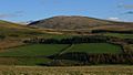
Looking west from the summit
|
|
| Highest point | |
| Elevation | 541 m (1,775 ft) |
| Prominence | c. 111 m |
| Listing | Wainwright |
| Geography | |

Lank Rigg
Location in Lake District

Lank Rigg
Location in the Borough of Copeland
|
|
| Location | Cumbria, England |
| Parent range | Lake District, Western Fells |
| OS grid | NY092119 |
| Topo map | OS Landranger 89, 90, Explorer OL4 |
Lank Rigg is a beautiful fell (which is another word for a hill or mountain) in the English Lake District. It stands south of Ennerdale in the Western Fells. This hill spreads out with gentle, grassy slopes. You can climb it from different spots along the Coldfell road. Lank Rigg also has old remains from people who lived there a very long time ago.
Contents
What is Lank Rigg Like?
The Western Fells are a group of hills in the Lake District. They form a big horseshoe shape around the long, wild valley of Ennerdale. Lank Rigg is the highest hill in the group at the very end of the southern part of this horseshoe.
Lank Rigg covers an area about 2 miles wide. It is surrounded by the River Calder and Worm Gill on three sides. To the northeast, a smaller hill called Whoap connects Lank Rigg to the main ridge. This ridge runs between Crag Fell and Caw Fell. The sides of Lank Rigg are mostly gentle and covered in grass. You might see a few scattered stones. There's also a small tarn (a mountain lake) just below the top, to the southwest.
History of Lank Rigg
Lank Rigg has signs of ancient people living there. Near the top, you can find a tumulus. This is a mound of earth or stones built over a grave. There are also various enclosures and cairns (piles of stones) near a spot called Tongue Bank. These old structures are even marked on Ordnance Survey maps as 'cairn', 'settlement', and 'homestead'. They show that people used this area many centuries ago.
Reaching the Summit
At the very top of Lank Rigg, you'll find an Ordnance Survey triangulation column. This is a concrete pillar used by mapmakers to measure distances. The view from the top isn't always the most exciting for other Lakeland fells. However, you can sometimes see Blencathra far away, which is a nice surprise! You also get a great view of the flat land near the coast.
A famous writer named Alfred Wainwright finished his book series, Pictorial Guide to the Lakeland Fells, on Lank Rigg. To celebrate, he buried a two-shilling coin (worth about ten pence today) under a stone at the summit. He wrote about it in his last book, hoping the first reader to reach the top would find it. He called it "a reckless thing to do." Even today, visitors sometimes hide coins there to remember Wainwright's fun act.
How to Climb Lank Rigg
The best way to get to Lank Rigg is from the Coldfell road. This road goes from Ennerdale Bridge to Calder Bridge. It's not fenced, so it's easy to access the fell.
- You can find a footpath that goes east between Blakeley Raise and Burn Edge. This path leads down into the upper Calder valley. From there, you can follow it to the low point (called a col) between Whoap and Lank Rigg.
- Some people like to make a longer trip. They start from the same spot and also visit Crag Fell and Grike as part of a circular walk.
- If you go further south on the Coldfell road, you'll find a small lane. This lane leads to the River Calder, right across from Tongue How. From there, you can climb the long southwestern slopes of Lank Rigg to reach the top.
Gallery
-
Lank Rigg from Flat Fell

