
Grike (Lake District) facts for kids
Quick facts for kids Grike |
|
|---|---|

Grike summit with its massive cairn and two smaller ones.
|
|
| Highest point | |
| Elevation | 488 m (1,601 ft) |
| Prominence | c. 37 m |
| Parent peak | Crag Fell |
| Listing | Wainwright |
| Geography | |

Grike
Location in Lake District

Grike
Location in the Borough of Copeland
|
|
| Location | Cumbria, England |
| Parent range | Lake District, Western Fells |
| OS grid | NY086141 |
| Topo map | OS Landranger 89, 90, Explorer OL4 |
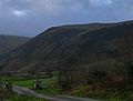
Grike is a cool hill located in the western part of England's famous Lake District. You can find it close to Ennerdale Water, a beautiful lake. Grike is part of a group of hills called the Lank Rigg group. It's special because it's the most westerly "Wainwright". A Wainwright is a fell (a local word for hill or mountain) that was described by a famous author named Alfred Wainwright in his guidebooks.
As you head west, the fells get smaller and flatter, leading towards the coast. Grike is one of these last big hills before the land flattens out. You can start your climb to Grike from nearby places like Kinniside or Ennerdale Bridge.
Contents
Exploring Grike's Landscape
The Western Fells are a triangular area of the Lake District. They are surrounded by rivers like the River Cocker and Wasdale. To the west, these hills gradually get smaller as they reach the flat coastal area of Cumberland.
The main high point of this region is Great Gable. From Great Gable, two main ridges spread out like arms around Ennerdale, a long, wild valley. Grike is located at the very end of the southern arm of these fells.
The land generally slopes west from Great Gable. This area divides the water that flows into Ennerdale and Wasdale. The fells in this part include Kirk Fell, Pillar, Scoat Fell, Haycock, and Caw Fell.
As you move further, other rivers begin to flow. One of these is Worm Gill, which runs south from Caw Fell. This river makes the ridge of hills turn north around the top of its valley. Beyond this point are the hills of the Lank Rigg group. These are the last high hills within the National Park. Crag Fell and Grike finish the line of hills going west. Lank Rigg itself is to the south, across the top of the River Calder.
Grike's Slopes and Surroundings
The western ridge of Crag Fell becomes a bit marshy before rising again to the gentle slopes of Grike. The southern sides of both Grike and Crag Fell have many conifer trees planted on them. These trees go all the way down to where the River Calder begins.
Grike's northern slopes also have forests where the land allows. The side of Grike facing Ennerdale is not as steep as Crag Fell's. However, it has deep cuts made by streams like Ben Gill and Red Gill. Grike doesn't look directly down onto Ennerdale Lake. Instead, it overlooks the flat land of the River Ehen, which flows out of the lake.
West of Grike's summit is a wide, gentle slope that leads down to Heckbarley. This is a flat area that is separated from the main hill by Stinking Gill and Goat Gill streams. Heckbarley has the only real cliffs on Grike, found on its northern side.
The ridge then turns south. It crosses a wooded area before reaching smaller tops like Blakeley Raise, Burn Edge, and Swarth Fell. Alfred Wainwright only included Blakeley Raise as part of Grike. However, some other writers include the whole ridge up to the edge of the National Park. The Coldfell road runs along the western side of these smaller hills.
Mining History of Grike
Iron mines used to operate beneath the northern slopes of Grike and Crag Fell. These mines were active from 1860 to 1896. Miners dug tunnels into the banks of Goat Gill and Red Gill. The main mine, called Main Drift Mine, was located between these two streams.
However, the amount of iron found was never as much as people hoped. Because of this, the mining business was not very successful.
Reaching Grike's Summit
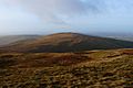
The very top of Grike has a huge stone cairn, which is a pile of stones. There are also two smaller cairns nearby. These cairns are built from the many stones found near the summit. The rest of the summit is mostly grassy. The main cairn is so big that it gives the fell its other local name, Stone Man. You might also see a weather station at the top, which is a more modern addition.
Views from the Top
From the summit, you can see far out towards the sea. However, views to the east are partly blocked by Crag Fell. You can get a good view of the horseshoe shape of the Western Fells. Surprisingly, you can also spot the tops of Dollywaggon Pike and Fairfield. Skiddaw and a small part of the North Western Fells can also be seen. The very end of Ennerdale Water is also visible from the top.
How to Climb Grike
There are a few ways to climb Grike. You can start from Ennerdale Bridge or from the car parks near where the lake's water flows out. From there, you can use the lane that leads to Crag Farm to get onto the fell.
A good path goes towards Crag Fell. You can follow this path until you reach Ben Gill, then turn right and head up the hillside.
Another starting point is the Coldfell road. From near the Kinniside Stone Circle, there's a track heading east. This track used to be the road to the Crag Fell Iron Mines. It crosses the first ridge between Heckbarley and Blakeley Raise. Then, it follows the southern side of Grike, just above the trees.
Gallery
-
The North face of Grike from Ennderdale
-
Eastern aspect of Grike from Crag Fell


