
Kirk Fell facts for kids
Quick facts for kids Kirk Fell |
|
|---|---|

Kirk Fell from Moses Trod by Ann Bowker
|
|
| Highest point | |
| Elevation | 802 m (2,631 ft) |
| Prominence | 181 m (594 ft) |
| Parent peak | Great Gable |
| Listing | Marilyn, Wainwright, Hewitt, Nuttall |
| Naming | |
| English translation | Hill above the church |
| Language of name | Old English |
| Geography | |

Kirk Fell
Location in Lake District

Kirk Fell
Location in the Borough of Copeland
|
|
| Location | Cumbria, England |
| Parent range | Lake District, Western Fells |
| OS grid | NY195104 |
| Topo map | OS Landranger 89, 90, Explorer OL4 |
| Listed summits of Kirk Fell | ||||
| Name | Grid ref | Height | Status | |
|---|---|---|---|---|
| Kirk Fell East Top | NY199107 | 787 m (2,581 ft) | Hewitt | |
Kirk Fell is a famous mountain, or "fell," located in the western part of the beautiful Lake District in England. It stands tall between two other well-known fells, Great Gable and Pillar. Kirk Fell is part of a long chain of mountains that circle the peaceful valley of Ennerdale. It also overlooks the Wasdale valley to its south.
Even though it's next to taller mountains, Kirk Fell is special because it's separated by lower passes called Black Sail and Beck Head. This gives it a high "relative height," meaning it stands out a lot from the land around it. Because of this, Kirk Fell is known as a Marilyn, and it's the thirteenth highest Marilyn in the Lake District.
Climbing Kirk Fell directly from Wasdale Head on its southwestern side is very steep. The famous fell-walker Alfred Wainwright even drew a funny picture about how hard it is! Most people prefer to climb it using the passes mentioned earlier. You can also climb Kirk Fell as part of a longer walk called the Mosedale Horseshoe. This walk explores the fells around Mosedale, which is a smaller valley branching off Wasdale.
Contents
Exploring Kirk Fell's Landscape
The Western Fells are a group of mountains in the Lake District. They form a triangle shape, with rivers on two sides. Great Gable is at the center of this high mountain area. From Great Gable, two main ridges spread out around Ennerdale, making the Western Fells look like a giant horseshoe. Kirk Fell is the first mountain on the southern arm of this horseshoe.
The main ridge goes west from Great Gable. It separates the streams that flow into Ennerdale from those that flow into Wasdale. The important fells along this part of the ridge include Kirk Fell, Pillar, Scoat Fell, Haycock, and Caw Fell. After these, you find the smaller Lank Rigg group.
Kirk Fell sits right at the top of Wasdale. It rises between the main streams of Mosedale and Lingmell Becks. From Wasdale, it looks like a cone with a flat top. The sides facing Wasdale are very steep, covered in grass and loose rocks. There's not much to break up the view on these slopes. Ill Gill is the only stream on these steep sides. It flows from the dip between the main summit and the east top.

Black Sail Pass and Ennerdale Side
To the west of Kirk Fell, between it and Pillar, is Black Sail Pass. This pass is a walking route from Wasdale to Ennerdale. From Ennerdale, you can continue to Buttermere via Scarth Gap. This path is now used for fun walks, but long ago, it was an important route for trading goods between the valleys.
The top of Black Sail Pass is about 541 meters (1,775 feet) high. An old boundary, called the Ennerdale Fence, crosses the pass here. This fence marks the edge of the land that drains into Ennerdale. While some parts of the "fence" are stone walls, the part going over Kirk Fell is mostly just old posts.
The Ennerdale side of Kirk Fell has more interesting features. However, it's harder to reach because the valley head is quite remote. A wall of rock forms the edge of the summit plateau. These rocks are called Boat How Crags to the east and Kirkfell Crags to the west. Between them is a hollow called Baysoar Slack, where Sail Beck begins. Below these crags, the slopes are not as steep as on the Wasdale side. They lead down to the River Liza. Kirk Fell is not as prominent in Ennerdale because Great Gable stands at the very head of that valley.
Beck Head and Summit Plateau
To the east of Kirk Fell is Beck Head, a low point (col) that connects Kirk Fell to Great Gable. A small rocky ridge, Rib End, runs down from the summit plateau to the small lakes (tarns) in this dip. Beckhead Tarn is a small, shallow pool with a peaty bottom. Another smaller pool forms here after a lot of rain.
The top of Kirk Fell is shaped a bit like a figure eight. The narrow middle part is squeezed between Illgill Head and Baysoar Slack. The highest point is on the western side. A second, slightly lower top is on the other side. This second top is called Kirk Fell East Top. It is high enough (34 meters or 112 feet) to be considered a Hewitt mountain on its own. Between these two tops are Kirkfell Tarns, which are actually two small tarns. One is oval-shaped and deeper, while the other has a more uneven outline.
What Kirk Fell is Made Of
The top of Kirk Fell is covered with loose material like soil and rocks. Underneath this, you'll find layers of volcanic rock. These rocks are mostly a type of lava called andesite. The northern rocky cliffs show some granite rock. You can also see layers of broken rock (breccias), sandstone, and volcanic ash (tuffs).
The Top of Kirk Fell
The main summit of Kirk Fell has a cairn, which is a pile of stones. The east top also has a cairn on a rocky spot. You can still find parts of the old fence on the ridge, crossing both tops.
From the top, you get amazing views! Great Gable fills the eastern view, and you can see its famous Gable Crag and the Napes. Across Wasdale, you can see the Scafells, which include England's highest mountain. The High Stile and Grasmoor mountain ranges are also clearly visible in another direction. On a clear day, you might even catch glimpses of the distant Skiddaw and Helvellyn ranges.
How to Climb Kirk Fell
There is a path that goes straight up from the village of Wasdale Head to the summit. However, Alfred Wainwright described it as "a relentless and unremitting treadmill, a turf clutching crawl, not a walk." He said there are only three chances to stand upright! This means it's a very tough climb.
Easier ways to climb Kirk Fell are by using the Black Sail or Beck Head passes. Black Sail Pass offers gentler slopes. You can also use Black Sail to reach Kirk Fell from Ennerdale. If you're not staying at Black Sail Youth Hostel, the closest way to get there from Ennerdale is through Gatesgarth via Scarth Gap.
Kirk Fell can also be climbed as part of a longer circular walk called the Mosedale Horseshoe. This walk also includes other fells like Yewbarrow, Red Pike, Scoat Fell, and Pillar.
Images for kids
-
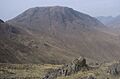
Kirk Fell from Moses Trod by Ann Bowker
-
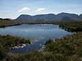
Great End and Scafell Pike seen from Kirk Fell Tarn between the two summits
