
High Stile facts for kids
Quick facts for kids High Stile |
|
|---|---|

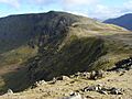
High Stile from Red Pike
|
|
| Highest point | |
| Elevation | 807 m (2,648 ft) |
| Prominence | 362 m (1,188 ft) |
| Parent peak | Great Gable |
| Listing | Marilyn, Hewitt, Wainwright, Nuttall |
| Geography | |

High Stile
Location in Lake District

High Stile
Location in Allerdale

High Stile
Location in the Borough of Copeland
|
|
| Location | Cumbria, England |
| Parent range | Lake District, Western Fells |
| OS grid | NY170148 |
| Topo map | OS Landranger 89, Explorer OL4 |
High Stile is a tall mountain in the western part of the Lake District in North West England. It stands 807 metres (2,648 ft) high. It is also known as a Marilyn, which means it's a hill with a certain height and a big drop all around it. Its relative height is 362 metres (1,187 ft), showing how much it stands out.
High Stile is the highest peak in a group of fells that stretch north-west from Great Gable towards Loweswater. It forms a famous trio of mountains with its neighbours, Red Pike and High Crag. These three fells look over the beautiful lake and village of Buttermere. On this side, you can see high cliffs, wild valleys called combs, and a small lake called Bleaberry Tarn. Many people like to climb High Stile as part of a longer walk across all three fells.
Contents
Exploring High Stile's Landscape
The Western Fells are a triangle-shaped area in the Lake District. They are bordered by the River Cocker to the north-east and Wasdale to the south-east. To the west, the hills become smaller as they reach the coast. At the centre of these high lands are Great Gable and its nearby peaks. Two main ridges spread out from here, forming a large horseshoe shape around the long, wild valley of Ennerdale. The highest part of the northern ridge includes the three Buttermere fells: High Crag, High Stile, and Red Pike.
The Buttermere Fells, also called Buttermere Edge, act like a natural dividing line. They send water to Buttermere on one side and Upper Ennerdale on the other. The sides facing Ennerdale are steep and rocky, with some areas of cliffs. The lower parts of these slopes have many conifer trees. On the other side of the narrow ridge, facing north, there are deep, bowl-shaped hollows called corries. Dark walls of rock tower over the lake below. The ridge continues south-east towards Haystacks and the Great Gable group. Beyond Red Pike to the west are Starling Dodd, Great Borne, and the Loweswater Fells.

Each of the three Buttermere Fells has a short ridge that points towards the lake. Deep hollows are carved out between these ridges. North-west of High Stile is Bleaberry Comb, with the cliffs of Chapel Crags behind it. Hidden deep inside is Bleaberry Tarn, a small lake that stays in shadow from November to March. Even though the rock walls above are very steep, the tarn is only about 15 ft (4.6 m) deep. It is full of trout fish. Water from Bleaberry Tarn flows into Buttermere through Sourmilk Gill. This stream reaches the lake just a few yards from where the lake's water flows out. A line of trees has been planted along the lake's edge.
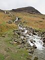
Birkness Comb, also known as Burtness Comb on maps, lies between the northern ridges of High Crag and High Stile. This hollow does not have a tarn because there is no natural dam to hold the water. Comb Beck flows straight down to the lake. Grey Crag and Eagle Crag are the main cliff faces on High Stile. These corries, carved out of the northern side, make the ridges connecting the three Buttermere Fells narrow and sharp.
Rocks and History of High Stile
The top of High Stile is made of different types of rock. These include siltstone, sandstone, and volcanic rocks like tuff and andesite. The northern slopes show older layers of mudstone, siltstone, and sandstone. Towards Red Pike, you can find intrusions of granite rock.
In Burtness Comb, there is a clear bank of rock debris. This debris runs along the outer edge of the upper hollow and then turns down into the lower hollow. It ends in a pile of rocks. This marks the path of a rock avalanche that fell from Grey Crag on the summit of High Stile. This happened about 11,000 years ago and was guided by a glacier. It is a unique feature in the Lake District.
Near the shore of Buttermere, you can find the remains of a small copper-mine. This mine was used for a short time from 1569 to 1570. It was then reopened in the 1820s.
Reaching the Summit
The very highest point of High Stile is a little bit out on the northern ridge, at the top of Grey Crag. It is marked by a pile of stones called a cairn. The highest point on the main ridge is only 3 ft (0.91 m) lower. Alfred Wainwright, a famous fell walker, thought this was the true summit. This spot has two main cairns side by side. To avoid confusion, some guidebooks call the true summit "Grey Crag" and the other high point "High Stile."
From the top, the view is amazing. You can see the North Western Fells across the Buttermere valley. Ennerdale Water and Crummock Water are also visible. If you walk carefully towards the edge, you can also see Bleaberry Tarn. The views of the cliffs in the surrounding hollows complete the beautiful scene in the foreground.
Climbing High Stile
People usually climb High Stile as part of a walk across the 'Buttermere Three' fells. This is because the north-eastern side is very steep and rough. Strong walkers might even continue their journey towards Haystacks, which is about 6 km (4 mi) to the south-east. Climbing directly from Ennerdale is not usually found in guidebooks because it involves walking through forest and steep bracken plants. High Stile is also part of Variation 1 on the famous Coast to Coast Walk.
If you want to climb High Stile directly, you can use either of the northern hollows. From the shore of Buttermere, a path goes up into Birkness Comb. From there, you can reach the northern ridge. From Buttermere village, you can use the path to Bleaberry Tarn. Then, you can find a way around the eastern end of Chapel Crags. If you are climbing from Ennerdale, you might use the route that goes up Red Pike first.
Images for kids
-
High Stile from Red Pike
-
Comb Beck, with High Stile above
