High Crag facts for kids
Quick facts for kids High Crag |
|
|---|---|

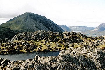
High Crag from the summit tarn on Haystacks
|
|
| Highest point | |
| Elevation | 744 m (2,441 ft) |
| Prominence | c. 29 m |
| Listing | Wainwright, Hewitt, Nuttall |
| Geography | |
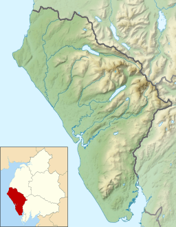
| Location | Cumbria, England |
| Parent range | Lake District, Western Fells |
| OS grid | NY180140 |
| Topo map | OS Landranger 89 |
High Crag is a mountain in the western part of England's Lake District. It stands at the southern end of the High Stile ridge. This ridge separates two beautiful valleys: Ennerdale and Buttermere.
Many people enjoy climbing High Crag as part of a longer ridge walk. You can start from the Black Sail youth hostel. Another popular starting point is Buttermere, by way of Scarth Gap. From the top, you can see amazing views of Great Gable and the Scafells.
Contents
Exploring the Western Fells and High Crag's Location
The Western Fells are a group of mountains in the Lake District. They form a triangle shape. The River Cocker borders them to the northeast. Wasdale is to the southeast. To the west, the hills get smaller as they reach the coast.
Great Gable is a central mountain in this area. Two main ridges spread out from it, like a horseshoe. These ridges surround the long, wild Ennerdale valley. High Crag is part of the northern ridge.
The Buttermere Fells: High Crag's Ridge
High Crag, High Stile, and Red Pike make up the Buttermere Fells. This group of mountains is also called Buttermere Edge. They form the natural boundary between Buttermere lake and Upper Ennerdale valley.
The sides of the mountains facing Ennerdale are steep and rocky. Some lower parts have conifer trees. On the other side, facing Buttermere, there are deep, bowl-shaped valleys called corries. These corries have dark, rocky walls that look down over the lake.
The ridge continues southeast from High Crag. It leads to Haystacks and the Great Gable area. To the west of Red Pike, you'll find Starling Dodd, Great Borne, and the Loweswater Fells.
High Crag's Unique Features
High Crag is at the eastern end of the Buttermere Fells. One of its most striking features is the large, loose rock slopes of Gamlin End. Here, the high ground drops sharply.
About 700 feet below, the ridge becomes flatter. Then, it rises again to form a rocky top called Seat. After Seat, there's a final steep path down to Scarth Gap. Scarth Gap is a popular path for walkers between Buttermere and Ennerdale.
Valleys and Crags Around High Crag
All three Buttermere Fells have rocky spurs that reach towards the lake. These rocky walls create two valleys: Birkness Comb and Bleaberry Comb. Birkness Comb is also known as Burtness Comb on maps.
Birkness Comb lies between the northern ridges of High Crag and High Stile. A stream called Comb Beck drains into Buttermere from here. The head of this valley is surrounded by crags. Sheepbone Buttress is on the side of High Crag. High Crag also shares Comb Crags, which line the ridge. This large, scooped-out valley makes the Buttermere Edge ridge quite narrow. The northern spur of High Crag also ends suddenly as High Crag Buttress, a rock layer just above the lakeshore.
Understanding High Crag's Rocks: Geology
The rocks at the top of High Crag are from the Birker Fell Formation. These are mostly lava rocks called andesite. They have small crystals inside them. You can also find layers of volcanic sandstone and tuff (rock made from volcanic ash).
Seat, a nearby outcrop, is made of different andesite lavas. These rocks have patterns from their flow. They also have tiny crystals of quartz and feldspar.
Reaching the Top: The Summit
The top of High Crag is shaped like a triangle. There is a pile of stones, called a cairn, at the highest point above Gamlin End. The view from the summit is partly blocked by High Stile. However, the head of Ennerdale looks wonderful. The Scafells mountains stand tall behind it.
You can also catch glimpses of Skiddaw and the Helvellyn range in the distance. If you walk a short distance northwest towards the edge of the crags, you will see Buttermere and Crummock Water lakes.
Climbing High Crag: Popular Routes
You can reach Scarth Gap from the head of Ennerdale. However, this is a very long walk unless you are staying at the Black Sail Youth Hostel.
A more common way to approach High Crag is from the Buttermere valley. You can park your car at Gatesgarth. On the Buttermere side, a path cuts across the top of the pass. This means you don't have to climb Seat first. Instead, you can go straight to the long climb up the scree slopes of Gamlin End.
The famous fell walker Alfred Wainwright also noted another way to climb High Crag. You can go up from the shore of Buttermere through Birkness Comb. This route involves climbing a grassy path through the crags.
 | Kyle Baker |
 | Joseph Yoakum |
 | Laura Wheeler Waring |
 | Henry Ossawa Tanner |


