
Great Borne facts for kids
Quick facts for kids Great Borne |
|
|---|---|

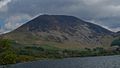
Great Borne seen from near the western end of Ennerdale Water.
|
|
| Highest point | |
| Elevation | 616 m (2,021 ft) |
| Prominence | 113 m (371 ft) |
| Parent peak | High Stile |
| Listing | Hewitt, Nuttall, Wainwright |
| Geography | |

Great Borne
Location in Lake District

Great Borne
Location in Allerdale

Great Borne
Location in the Borough of Copeland
|
|
| Location | Cumbria, England |
| Parent range | Lake District, Western Fells |
| OS grid | NY124163 |
| Topo map | OS Landranger 89, OS Explorer 4 |
Great Borne is a fell (which is a type of mountain or hill) located in the beautiful Lake District in England. It stands at a height of 616 meters (about 2,021 feet). This mountain is quite hidden away. It sits at the far western end of a long ridge. This ridge separates the Ennerdale and Buttermere valleys.
Contents
What's in a Name?
The name Great Borne mostly refers to the very top part of the mountain. However, many people in West Cumbria actually call this fell Herdus.
Some experts, like Bill Birkett, even see Great Borne and Herdus as two separate fells. Herdus's top is about half a kilometer west of Great Borne. It is also a bit lower, at 562 meters.
The name "Great Borne" comes from the French language. It means "Great Boundary." This is because in the 13th century, the mountain marked the edge of the Loweswater forest. Another idea is that it comes from an old English word, "bourne," meaning a stream flowing from a spring. This would make the name mean "Great Stream."
Mountain Features and Rocks
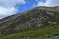
The southern sides of Great Borne are very interesting. They drop steeply down towards Ennerdale Water. You can see steep cliffs and scree (loose rocks). These slopes are made of a pink rock called granophyre. This rock gives the slopes a reddish color, as you can see in pictures.
There's a special place between Great Borne and Herdus. This is where two different types of rock meet. One is called the Skiddaw Group and the other is the Ennerdale Granophyre.

A smaller, lower hill called Bowness Knott (333 meters high) is also to the south. This area is very important for geology. It is a Site of Special Scientific Interest (SSSI). This means it's a protected area because it shows how the granophyre rock touches the Skiddaw Slate. Bowness Knott offers great views of Ennerdale Water. It's also an easy climb from the car park nearby.
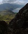
Historians have found signs of an old field system on the lower southern slopes. This system might be from the Middle Ages. It is located below the cliffs and scree. The northern sides of Great Borne go down to the Floutern Pass. This pass is a path for people walking between Ennerdale and Buttermere. To the east, Great Borne is connected to the nearby mountain of Starling Dodd by a ridge. The western slopes quickly go down to the flat land of the west Cumbrian plain.
How to Climb Great Borne
Most people start their climb of Great Borne from the Ennerdale side. The car park below Bowness Knott is a common starting point. The path follows a stream called Rake Beck for a short distance. It then goes around the Herdus cliffs on the eastern side to reach the top.
Climbing from the Floutern Pass is not usually suggested. The top of the pass can be very wet and muddy. The path from there is also quite long and winding.
The Summit of Great Borne
The very top of Great Borne has two separate high points. They are separated by a shallow dip. The southern high point is a little bit taller. It has an Ordnance Survey trig point, which is a marker used for mapping. It also has a large shelter from the wind.
The northern high point has a big cairn (a pile of stones). This cairn can be seen from far away. It offers wide views of the Loweswater Fells. This large cairn is believed to be the boundary marker that gave the mountain its name.
Gallery
-
Great Borne seen from Ennerdale Water
-
South face of Great Borne
-

Great Borne from Crag Fell
-
Rake Beck on Great Borne


